By Jason Samenow / The Washington Post
Hurricane Florence is less than 48 hours away from making landfall on the Southeast coast with catastrophic impacts, from damaging winds to flash flooding to widespread power outages.
The storm’s surge could be over 9 feet at peak. Hurricane-force winds will bring down trees and damage homes and businesses. Like Hurricane Harvey did in 2017, Florence is expected to slow significantly when it reaches the coast, allowing the storm to dump a catastrophic amount of rain in the Carolinas.
Florence will be in all likelihood the most intense storm to strike the region in at least 25 years, since Hugo.
- Related

As big hurricane nears, Boeing will suspend assembly in SCSep 10, 2018
Trump touts his ‘underappreciated’ job on Puerto Rico stormSep 12, 2018
DHS says FEMA money transfer won’t harm hurricane reliefSep 12, 2018
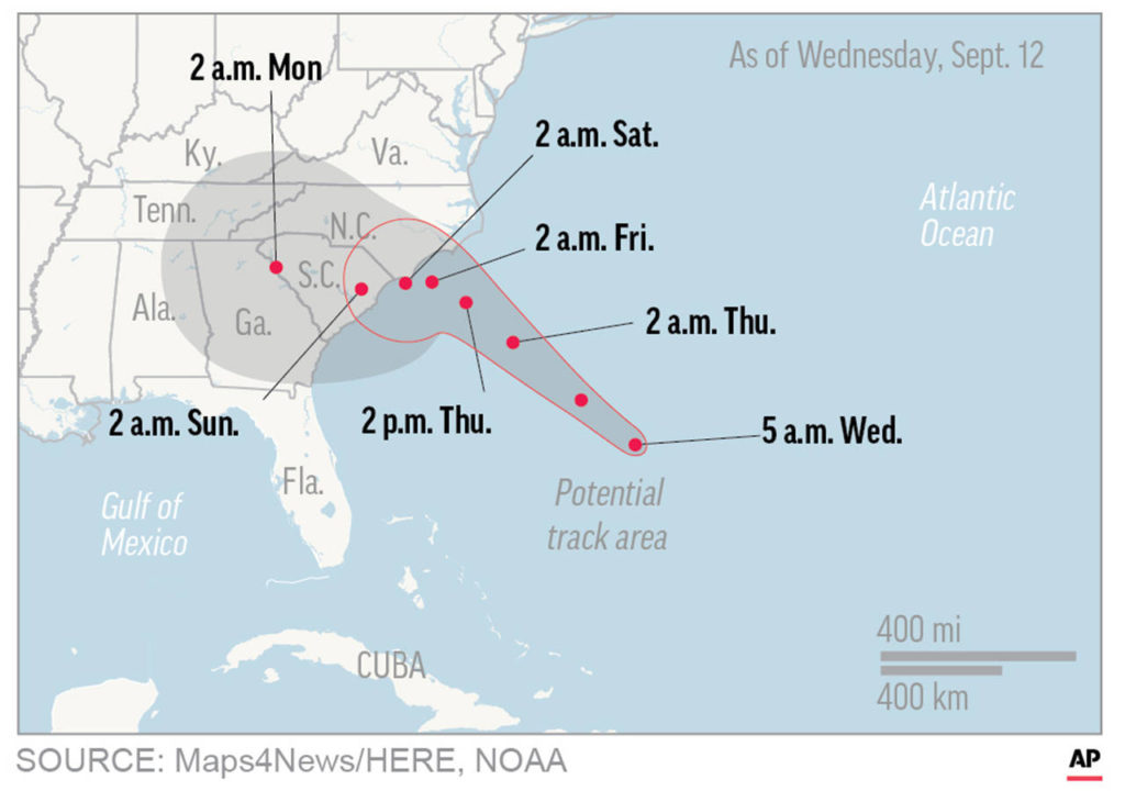
Forecasts project the center of Florence to make landfall around the South and North Carolina border on Friday as a Category 3 or 4 hurricane. As it nears the coast, the storm’s forward motion will slow to a crawl, but the winds and rain will continue full-strength.
“This will likely be the storm of a lifetime for portions of the Carolina coast,” the National Weather Service in Wilminton, North Carolina, wrote Tuesday, “and that’s saying a lot given the impacts we’ve seen from hurricanes Diana, Hugo, Fran, Bonnie, Floyd, and Matthew.”
The National Hurricane Center is warning of a triple threat in the Carolinas:
• A “life-threatening storm surge” at the coast – a tsunami-like rise in ocean water over normally dry land;
• “Life-threatening freshwater flooding from a prolonged and exceptionally heavy rainfall event” from the coast to interior sections; and
• “Damaging hurricane-force winds” at the coast and some distance inland.

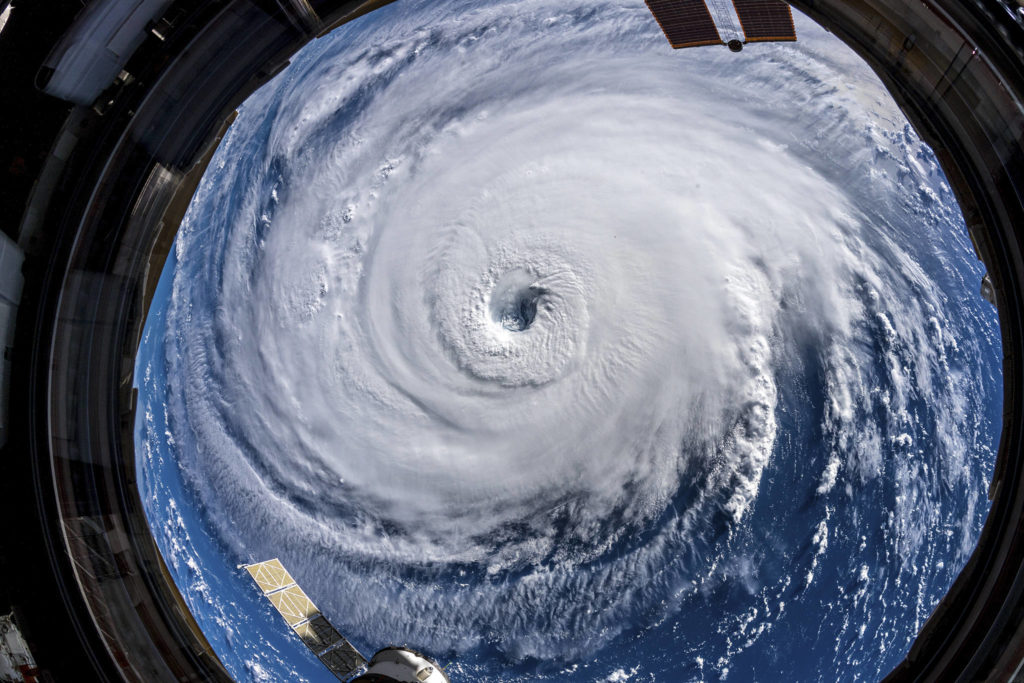
This map shows probable path of Hurricane Florence. (NASA)
Like Hurricane Harvey, which stalled over Texas in 2017, Florence could linger over the Southeast for several days after landfall, unloading 15 to 25 inches of rain and isolated amounts of up to 40 inches. Flooding from heavy rains is the second-leading cause of fatalities in landfalling tropical storms and hurricanes.
Enough rain could fall to break North Carolina’s record for a tropical storm — 24 inches — set near Wilmington during Hurricane Floyd in 1999, said Greg Carbin, chief of forecast operations at the Weather Service’s national prediction center.
More than 1.5 million people have been ordered to evacuate coastal areas ahead of the storm because of both destructive winds and a storm surge that could place normally dry land under at least 10 feet of water.
“All interests from South Carolina into the Mid-Atlantic region should ensure they have their hurricane plan in place and follow any advice given by local officials,” the Hurricane Center said.
“Even if you’ve ridden out storms before, this one is different,” North Carolina Democratic Gov. Roy Cooper said at a Tuesday news conference, in which he announced the mandatory evacuation of the state’s popular and fragile barrier islands. “It’s an extremely dangerous, life-threatening, historic hurricane,” he said, noting the forecast for days and days of rain.

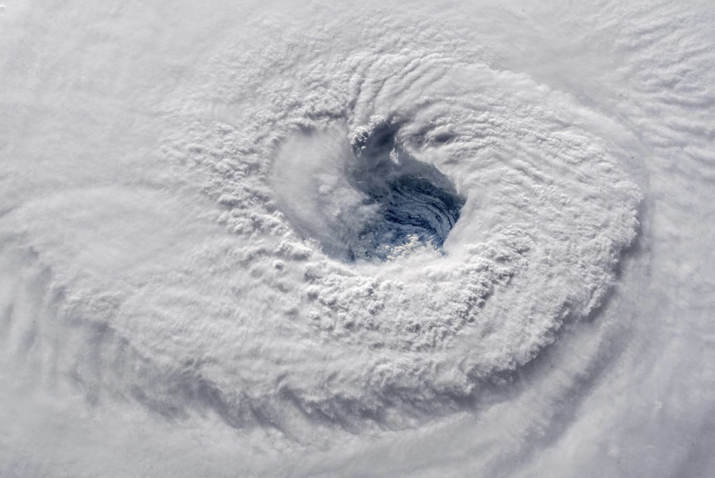
Astronaut Alexander Gerst says staring down the gaping eye of Hurricane Florence from the International Space Station is “chilling.” (Alexander Gerst/NASA)
Federal officials warned that the millions of people in Florence’s sights could be without electricity for weeks, if high winds down power lines and massive rainfall floods equipment. There are 16 nuclear reactors in the region, and crews at the one closest to where landfall is forecast readied the station, at Brunswick, for a shutdown.
The monstrous storm has forced the closing of hundreds of schools throughout the region. Because Florence’s rainfall is expected to pound areas far from the coast, the University of North Carolina at Chapel Hill, Duke and North Carolina State universities canceled classes through week’s end. Boeing and Volvo shut down their Charleston factories, idling thousands who build 787s and sedans.
President Donald Trump has approved emergency disaster declarations for the Carolinas and Virginia, which frees up funds for relief and recovery. “We’re as ready as anybody has ever been,” he said after a briefing with Federal Emergency Management Agency Administrator William “Brock” Long and Homeland Security Secretary Kirstjen Nielsen.
He also canceled campaign rallies in Cape Girardeau, Missouri, and in Mississippi.
“Florence could be the most dangerous storm in the history of the Carolinas,” Long, a North Carolina native, tweeted Tuesday.

The surf washes up the shore at low tide as Andrew Lingle walks along the beach as Hurricane Florence approaches the east coast in Atlantic Beach, North Carolina, on Wednesday, Sept. 12. (AP Photo/David Goldman)
As of 5 a.m. Wednesday, Florence’s top winds were 130 mph, and it was barreling west-northwest at 17 mph, about 575 miles southeast of Cape Fear, North Carolina.
The Hurricane Center predicts its maximum winds could still reach 145 mph at peak intensity on Wednesday. Some modest weakening may occur just before landfall, but Florence is predicted to approach the coast as a Category 3 or 4 storm.
The storm’s zone of hurricane-force winds expanded Tuesday, extending 70 miles from the center, while tropical-storm-force winds extend 175 miles outward.
A tropical storm warning was issued from north of Duck, N.C., to the North Carolina-Virginia border. Hurricane warnings were issued for the South Santee River in South Carolina to Duck, N.C, and Albemarle and Pamlico sounds. This includes Wilmington, N.C. Hurricane watches extended north to the North Carolina-Virginia border and south to the South Santee River, including the Charleston area.
In coastal areas of the Southeast and Mid-Atlantic, heavy surf and elevated water levels are expected to arrive by Wednesday morning, and rainfall could begin by late Wednesday night and Thursday morning. The rain is then predicted to spread inland by Friday and potentially continue for days as the storm slows or stalls.
Tropical-storm-force winds could reach the coastline as early as Thursday morning, at which point all outdoor preparations should be completed.
Extremely dangerous hurricane-force winds could batter coastal locations by Friday. Hurricane-to-tropical-storm-force winds could extend well inland, depending on the storm’s track.
Like a bulldozer, the storm’s winds and forward motion will push a tremendous amount of water onshore when it makes landfall. The storm surge, or rise in water above normally dry land at the coast, could reach up to more than a story high, or 13 feet, if the maximum surge coincides with high tide.
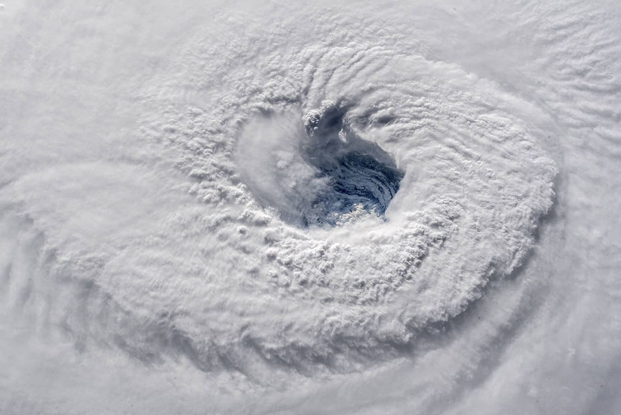
The eye of Hurricane Florence is seen from the International Space Station. (Alexander Gerst/NASA)
Jeff Masters, the meteorologist who writes Weather Underground’s Category 6 blog, reported that a maximum surge of 15 to 20 feet is possible, which would rival heights from hurricanes Hugo (1989) and Hazel (1954).
The biggest surge should occur just to the north of where the eye of the storm comes ashore, which the Hurricane Center projects in southeastern North Carolina.
The surge will result in “large areas of deep inundation … enhanced by battering waves,” the Weather Service said. It warned of likely “structural damage to buildings … with several potentially washing away,” “flooded or washed-out coastal roads” and “major damage to marinas.”
Storm surge warnings were issued from South Santee River in South Carolina to Duck, North Carolina. The Charleston area is under a storm surge watch.
The Hurricane Center projects the following surge heights above normally dry land, if the maximum surge coincides with high tide:
• Cape Fear to Cape Lookout, including the Neuse and Pamlico Rivers: 9 to 13 feet;
• North Myrtle Beach to Cape Fear: 6 to 9 feet;
• Cape Lookout to Ocracoke Inlet: 6 to 9 feet;
• South Santee River to North Myrtle Beach: 4 to 6 feet;
• Ocracoke Inlet to North Carolina/Virginia Border: 4 to 6 feet; and
• Edisto Beach to South Santee River: 2 to 4 feet.
Models agree that a building high-pressure zone north of the storm will cause it to slow or stall once it reaches the coast or shortly thereafter. There is relatively strong agreement that excessive amounts of rain will fall in southeastern North Carolina.
“Flood waters may enter numerous structures, and some may become uninhabitable or washed away,” the Weather Service warned.
Where exactly the zone of heaviest rain sets up as the storm meanders inland is highly uncertain, but models suggest it may concentrate in southern North Carolina and northern South Carolina through the weekend.
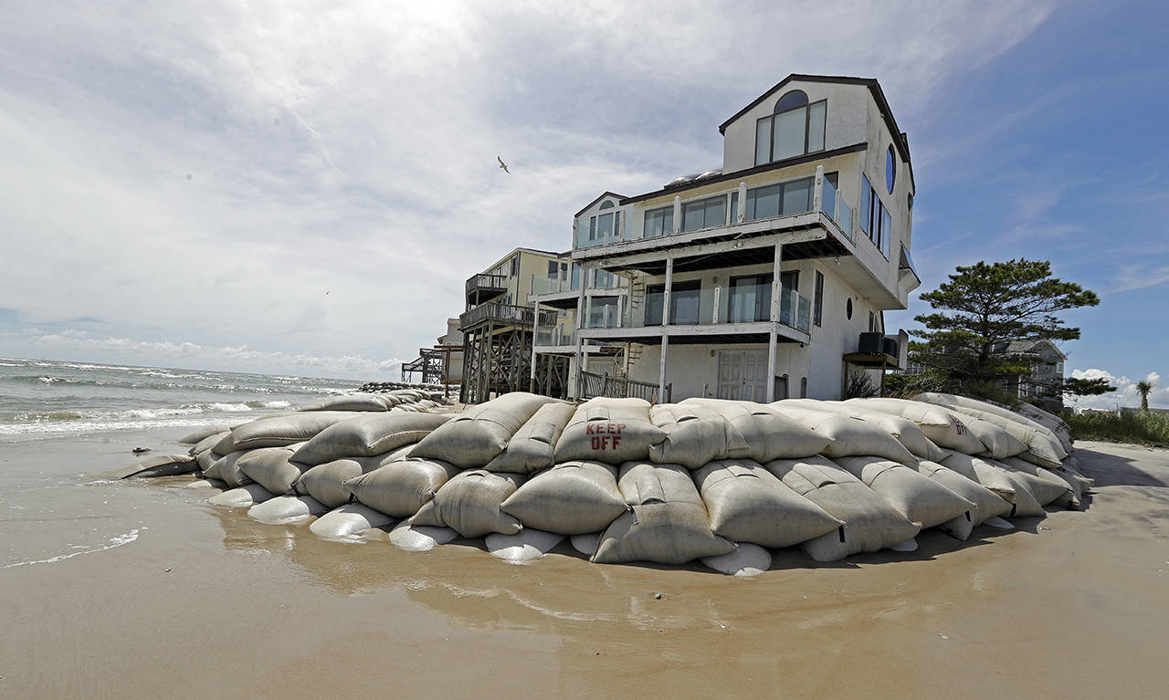
Sand bags surround homes on North Topsail Beach, North Carolina, on Wednesday as Hurricane Florence threatens the coast. (AP Photo/Chuck Burton)
There is some possibility the storm reverses course early next week and turns back north toward Virginia, albeit significantly weakened. This region will be particularly susceptible to flooding because of far-above-normal rainfall in the region since May. In addition, because the ground is likely to be saturated, trees would be vulnerable in strong winds.
The strongest winds will occur where and when the storm makes landfall in a ring around the calm eye of the storm known as the eyewall. If the storm makes landfall as a Category 4, these winds will be destructive, sustained at up to 130 mph or so with higher gusts.
The zone where these intense winds occur will be narrow, but the effects will probably be devastating, similar to a strong tornado. The Hurricane Center describes the types of damage associated with Category 4 winds:
Well-built framed homes can sustain severe damage with loss of most of the roof structure and/or some exterior walls. Most trees will be snapped or uprooted and power poles downed. Fallen trees and power poles will isolate residential areas. Power outages will last weeks to possibly months. Most of the area will be uninhabitable for weeks or months.
Outside this zone of destructive winds, damaging winds are still likely, even some distance inland from the coast, which would lead to minor structural damage, downed trees and widespread power outages.
A power outage model run at the University of Michigan projects that 3.6 million customers will without electricity because of the storm, mostly in the eastern half of North Carolina.
If the storm stalls in the eastern Carolinas as or just after the storm makes landfall, these wind impacts will be magnified.
Where the storm makes landfall has implications for where the strongest winds and biggest rise in water at the coast occurs, but strong winds and extreme rainfall could occur at great distances from the landfall location. Keeping this in mind, here is the likelihood of landfall at different locations based on our evaluation of model data:
• 80 percent in the Carolinas;
• 10 percent offshore; and
• 10 percent between North Florida and Georgia.
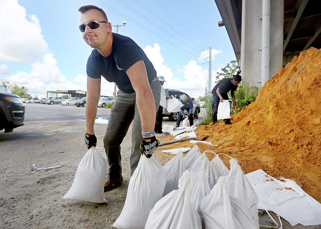
Kevin Orth loads sandbags into cars to prepare for Hurricane Florence on Monday in Charleston, South Carolina. (Grace Beahm Alford/The Post And Courier via AP)
Even in the unlikely event that the storm center remains just offshore, it will almost certainly come close enough to bring dangerous wind and flooding to coastal areas. Areas farther to the north and west may be somewhat spared in this scenario.
While it is extremely likely that the eastern Carolinas will be hard hit by the storm Thursday into Friday, the storm’s direction becomes far less certain over the weekend and next week.
“Models are indicating that the steering currents will collapse by Friday when Florence is approaching the southeast U.S. coast,” the Hurricane Center wrote. “The weak steering currents are expected to continue through the weekend, which makes the forecast track on days 3-5 quite uncertain.”
Since early in the week, the post-landfall storm track has shifted more to the south, possibly pushing it down the coast of South Carolina or into its interior — in the opposite direction storms normally track before possibly returning north.
If Florence makes landfall as a Category 4 in North Carolina, it would be the strongest storm to come ashore that far north on record.
If a major hurricane (Category 3 or higher) does make landfall along the Southeast coast north of Florida, the rarity of such an event is relevant. Since 1851, only 10 major hurricanes have done so, and the most recent was Fran in 1996, 22 years ago. Hugo in 1989 was the one before that and was a Category 4 at landfall. No hurricane has made landfall as a Category 5 in this region on record.
Many people in the Southeast and Mid-Atlantic probably have not experienced a storm of the potential magnitude of Florence.
The Washington Post’s Ann Gerhart, Joel Achenbach and Brian McNoldy contributed to this report.
Talk to us
> Give us your news tips.
> Send us a letter to the editor.
> More Herald contact information.
Gallery