Better data, better trails: Study looks at social media uses
Published 1:30 am Sunday, December 2, 2018


By Jessi Loerch
Washington Trails Association
Using Washington Trails Association trip reports and social media data, researchers at the University of Washington and the U.S. Forest Service have created a model to give the Mount Baker-Snoqualmie National Forest better information about when and where hikers are using trails. The information can help the agency best manage its limited resources.
• • •
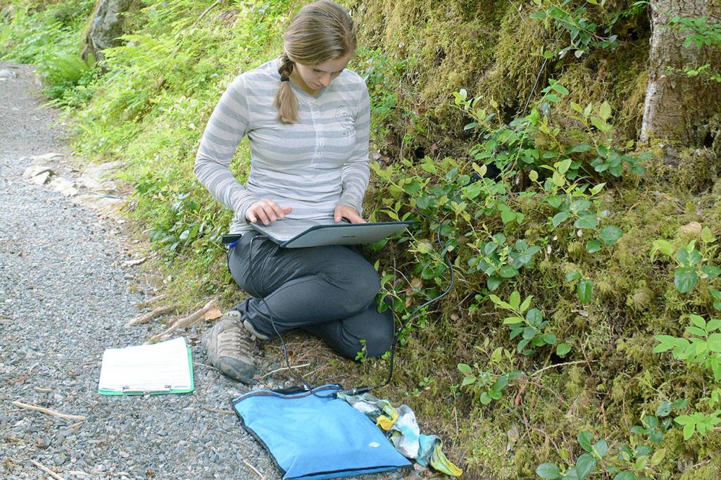
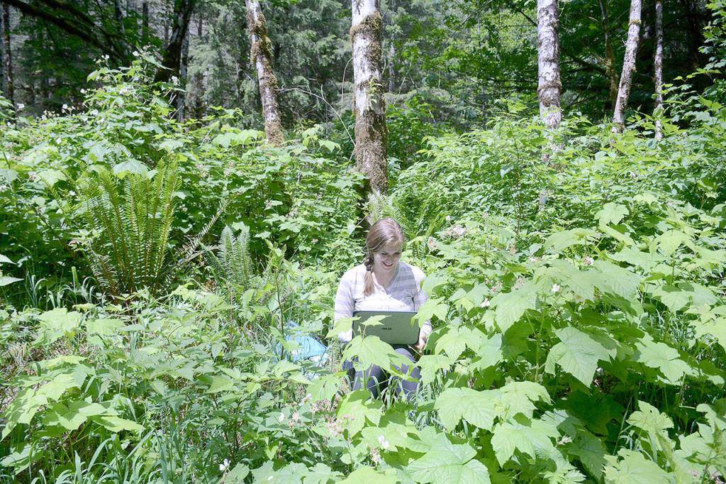
Emmi Lia sat on moss-covered ground in the Middle Fork of the Snoqualmie River Valley. She balanced a laptop on her legs, looked at the screen and jiggled a connection to a wire running up to a tree. She appeared to be downloading data directly from the tree. In reality, her computer was plugged into a small infrared counter discretely attached to the trunk.
For weeks, the counter had been keeping track of how many hikers passed by on the adjacent trail. Lia needed the data but the tracker wasn’t cooperating. Electronic gadgets, even when well protected, don’t enjoy the wetness of a Pacific Northwest forest. Lia was persistent, and eventually she convinced the tracker and laptop to talk.
Lia is a research assistant at the University of Washington Earth Lab. She spends a lot of time outdoors, collecting data on how many people are using trails or driving on roads in the Mount Baker-Snoqualmie National Forest. It’s important work, but collecting data in this manner is expensive and time consuming.
The data Lia is collecting supports a bigger project to use social media data and trip reports from wta.org to give the Mount Baker-Snoqualmie National Forest a better understanding of how many people are using specific trails, and when. The project will give forest managers more information to help them make informed decisions about how best to use their limited resources to support recreation on the national forest.
“For more than 50 years, trip reports have been an important — and high quality — source of information for trail users and land managers. It’s pretty cool that something so rooted in community and advocacy has the potential to help land managers create better recreation opportunities for hikers on public lands,” said Loren Drummond, WTA’s digital content manager.
“People often ask us if trip reports matter, if anyone reads them. Not only do we read them, but now I can honestly say they are shaping the future of trails.”
More data, more informed decisions
The Mount Baker-Snoqualmie National Forest is a big place. On the west side of the Cascades, it stretches from Mount Rainier National Park to the Canadian border. It’s also a popular place for hikers, bikers, runners, horseback riders and anglers. It’s one of the most-visited forests in the country.
Keeping track of all of those people using traditional methods has been labor intensive and expensive. Once every five years, the forest conducts a survey for the National Visitor Use Monitoring program, a national effort to document how many people are using forests, who they are and how they visit forests. The survey gives information about forestwide usage, but it doesn’t provide details on a finer scale, for example, at specific trails or even across ranger districts.
Forest managers need to know, in greater detail, how many people are using trails, which trails they are using and when.
Sarah Lange, an Everett-based outdoor-recreation planner for the Mount Baker-Snoqualmie National Forest, did her graduate work at the University of Washington. From her time there, she was familiar with research to use social media to estimate visitation at national parks. She and other Forest Service employees wondered if the same method could be used for the forest. They reached out to researchers at UW to see if they could collaborate on a project.
Lange says that having fine-level information on trail use can make a better case for funding. The forest relies heavily on grants, and many grants want to know how many people a project will benefit.
“If you want to talk about toilets and trailhead parking and what other resources we need, we need information,” Lange said. “We get anecdotal information, but there are places where that gets mushy. … We need evidence-based information to determine where money and resources are most needed.”
How does it work?
For this project, Lia and other researchers are working to build a model that can use anonymous trip report and social media data to help predict when and where hikers are using trails. The model is a complex, data-driven tool that can predict use on trails without counting hikers in person on those actual trails.
Creating the best model possible requires data — the more data the better. Lia jokes that models are like monsters. They eat data and the more you feed them, the stronger they get. In this case, there are two main types of data: on-the-ground counts of people and social media posts shared online. The two support each other. The social media data get used to estimate the popularity of trails, and the on-the-ground data test whether it’s accurate and help further refine the model to make it more precise.
The online data include information that is marked with a date and location, such as WTA trip reports and posts on Flickr, Instagram and Twitter. With those data, Spencer Wood and David Fisher, who work with Lia at UW, built a model to predict how often trails are being used. It’s a collaborative process. Dale Blahna and Eric White, research social scientists for the Forest Service’s Pacific Northwest Research Station, were also a key part of the team, working with UW to generate ideas to improve the model and data collection process.
Wood says that, of all the information sources that go into the model, trip reports are “the hands-down winners. ” Trip reports from WTA have a 90 percent correlation with monthly counts of hikers from trailheads using infrared counters. It seems logical that more trip reports mean more visitors, but scientists can’t simply assume that because a trail has more trip reports, it has more visitors. They need data to verify that, and the on-the ground counts have done so.
That data is collected in a number of ways. Tools for counting cars or hikers are spread across the Mount Baker-Snoqualmie National Forest, on a set of roads and trails from busy to rarely visited, to get a good representative sample. Lia also collects other data, including counts of vehicles in parking lots whenever she’s passing by. At some trailheads, there are also signs asking hikers to send in vehicle counts to the researchers.
To predict visitation on a particular trail at a particular time, the model considers a lot of factors, such as weather, day of the week, time of year and whether it’s a holiday. For example, to predict visitation at the very popular Snow Lake Trail for a certain time, the model could look at similar days and consider how many trip reports had been filed, how many photos had been posted on Instagram and how many vehicles had been counted at the trailhead.
Why hikers should care
Having accurate, detailed information is vital to making good decisions about programs or projects that will affect forest visitors. Because the social media data are cheaper and faster to collect, and provide more information, they’re a powerful tool.
One of the big benefits for forest managers is that more information could help them with their planning and decision making. For instance, it could help managers know where more facilities, such as parking lots or restrooms, are needed. It could also help them predict the effects of decisions or natural events — for example, the effect on surrounding areas if a road were washed out, making access to trails more difficult.
More precise information could also improve recreation management. It could help plan for diverse hiking experiences, from popular trails with heavy traffic to little-known trails that offer a more solitary, adventurous experience. Ultimately, the information could be used to help educate hikers and other recreationists. Lange says that people have a more enjoyable time when they know what to expect. If they expect a crowded trail, they won’t be upset when they share the hike with many others.
With more knowledge about where hikers are, managers could also more easily consider nonhuman factors. For instance, if an area with a population of endangered plants or animals is getting a lot of visitors, land managers could take that into account as they work to protect the at-risk species.
Lia says that, eventually, the study could be the basis for further studies, which could provide even more benefits to hikers. A similar method is already being tested in New Mexico to see if it could work in a different landscape and on an area with many different land managers.
Lia is passionate about the value of being outdoors and the value of natural places. She loves that, for this study, the data are coming directly from Washington’s hikers — and that the data will be used to help those same hikers have a better experience outdoors.
“If we want to enjoy wild places and protect them for future generations, we need to know how many people are visiting them, and when,” she said. “The value in spending the effort and energy on this project is in finding a more effective and more cost-efficient way of measuring visitation. And this information filters back to the people who visit these trails to improve their experience.
Washington Trails Association promotes hiking as a way to inspire a people to protect Washington’s natural places. Get inspired to go hiking and learn how you can help protect trails at www.wta.org.
Read the study
Read the scientific study explaining how trip reports and social media data stack up against more traditional ways to measure trail usage at www.fs.usda.gov/treesearch/pubs/56407.