How to weigh in on Everett light rail’s route and stations
Published 1:30 am Tuesday, March 15, 2022


EVERETT — People again can weigh in on early light rail station locations for the Everett Link extension.
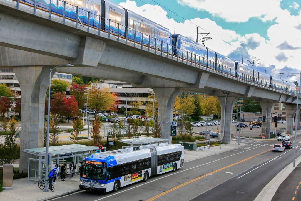
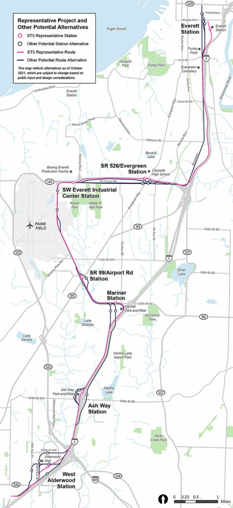
Sound Transit, which spans parts of King, Pierce and Snohomish counties, is developing the 16-mile expansion between Lynnwood City Center and Everett Station. It includes six stations and an operations-and-maintenance facility, and the agency could add a seventh provisional station should funding become available.
Most of the stations are expected to open in 2037. Two locations north of Paine Field might not open until 2041 if $600 million isn’t found to keep them on time with the others.
Through April 3, Sound Transit is collecting input on alternative station locations being considered and evaluated by staff before further design and right-of-way acquisitions.
People can review the explanation of each alternative’s features and potential drawbacks at the online open house at everettlink.participate.online.
Early scoping comments generally expressed support for transit-oriented development and putting stations close to existing population, retail and work centers. They also showed concern about displacement, traffic and potential low ridership for some stations.
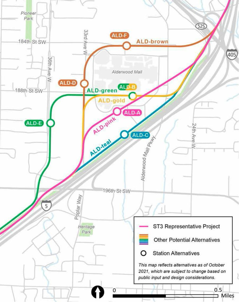
West Alderwood
Alternative stations are on the mall’s campus, closer to the Interurban Trail.
Options D and F had the most comment support.
Option D is along 33rd Avenue near 188th Street SW, west of the mall. It’s the closest alternative to Community Transit’s planned Swift bus rapid transit Orange line. Lynnwood City Council members picked it as their preference.
Option F is along 184th Street SW, north of the mall.
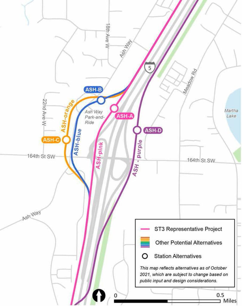
Ash Way
Three alternatives for Ash Way are west of I-5 and directly link with the Ash Way Park and Ride. One option is east of I-5, where the Snohomish County Council said it wants the station, near 164th Street SW.
Options D and A had the most comment support.
Option D is east of I-5 and closest to the Interurban Trail, but farthest from the existing transit hub.
Option A is on the eastern portion of the park and ride.
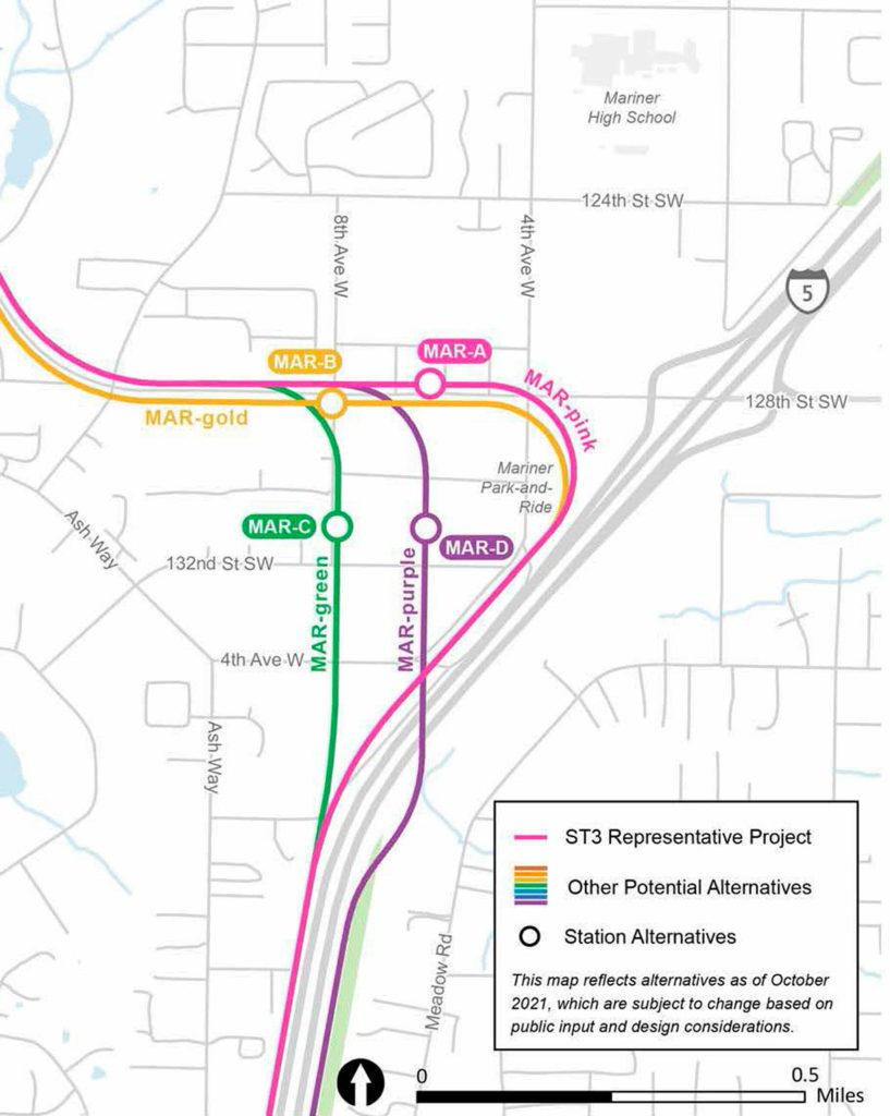
Mariner
The light rail line could go east or west of I-5. But all four station options are west of I-5, generally between 132nd Street Southwest and just north of 128th Street Southwest, and east of Eighth Avenue W.
Options A and D had the most comment support.
Option A would be along 128th Street SW, between Fourth and Eighth avenues W, where Swift bus rapid transit currently runs.
Option D is near 130th Street SW between Fourth and Eighth avenues W, which is what the Snohomish County Council prefers. The county is considering building a crossing over I-5 at 130th Street SW.
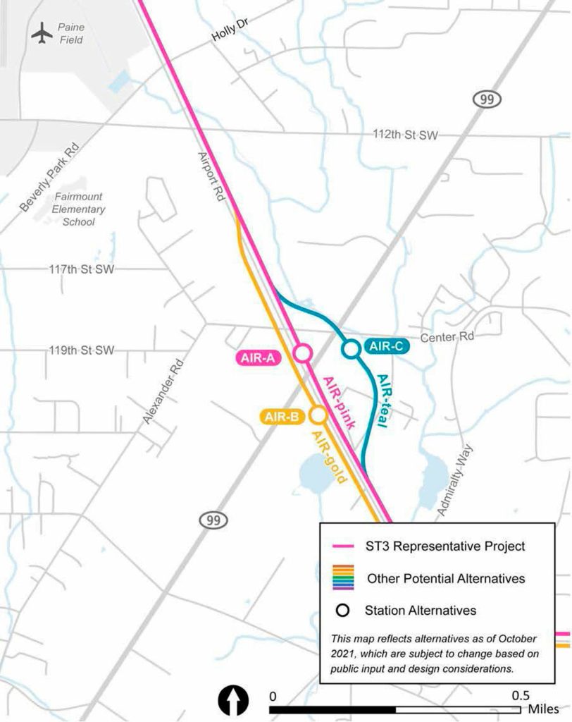
Airport Road and Highway 99 (provisional station)
The unfunded station includes three route and station alternatives. Two are north of Airport Road, and two are east of Highway 99.
More comments favored options A and B.
Option A is northwest of the intersection.
Option B is southeast of the intersection.
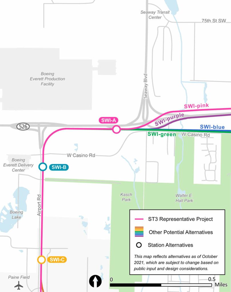
Southwest Industrial Center (Paine Field)
The route generally follows just east of Airport Road and curves to Highway 526. From there it could branch off depending on the Evergreen Way station alternative selected.
Station alternatives are just north of Paine Field, between Kasch Park Road and West Casino Road, and south of Highway 526 and off of West Casino Road.
More comments favored options C and A.
Option C is closest to Paine Field. Option A is between the highway and Casino Road.
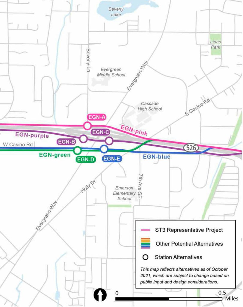
Evergreen Way and Highway 526
Four route and five station alternatives are part of the Evergreen Way destination. Four station alternatives are south of Highway 526, and three are west of Evergreen Way.
More comments favored options A and B.
Option A is north of the highway and west of Evergreen Way. It would be behind the apartment building under construction in the former Kmart lot.
Option B is south of the highway, north of Casino Road and west of Evergreen Way.
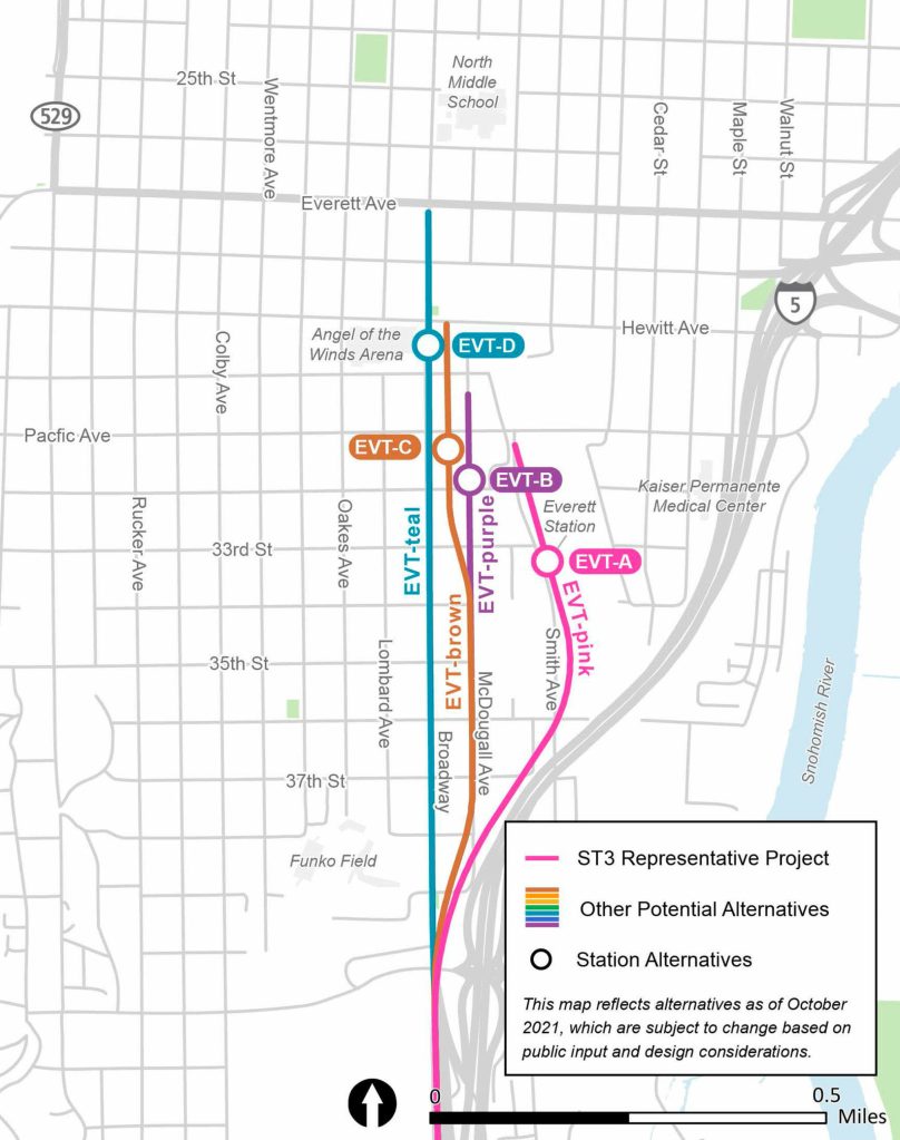
Everett Station
The line follows Broadway or I-5 to reach north Everett, but could bend away from Broadway depending on the station location picked.
One option has the line bump east from Broadway toward Smith Avenue to reach Everett Station. Other station options are at Angel of the Winds Arena via Broadway, Broadway and Pacific Avenue via McDougall Avenue, or 32nd Street and McDougall Avenue.
More comments favored options A and C.
Option A is at Everett Station.
Option C is southeast of the intersection of Broadway and Pacific Avenue.
Operations and Maintenance Facility North
The building needs access to the main track and between 60 and 70 acres to store 150 light rail cars for cleaning and repairs.
About 450 full-time employees are expected to work and have administrative and locker space there.
Staff identified six suitable sites between the 164th Street SW and the Paine Field area.
More comments supported sites at Airport Road and 94th Street SW and at Airport Road and 100th Street SW.
Ben Watanabe: bwatanabe@heraldnet.com; 425-339-3037; Twitter @benwatanabe.