2. Built on pudding: Can modern quake engineering prevail?
Published 8:01 pm Sunday, May 16, 2021


This is the second of three stories about a little-known geologic fault that could trigger a major earthquake in Snohomish and Island counties.
EVERETT — You’re strolling across a flat sandy beach, on the wet part, where the waves roll in and out.
You stop to wiggle your toes. You sink.
In an earthquake, this can happen to buildings, too, if they aren’t specially engineered.
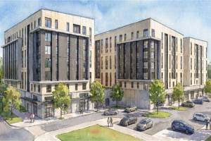
Some of Snohomish County’s most ambitious housing projects, like the new luxury apartments on Everett’s waterfront, have been permitted for construction on top of saturated soils that are prone to liquefy.
These newer buildings are engineered to withstand shaking. Developers say they are safe. Older ones are not.
We live in a region at risk of major earthquakes from the Cascadia Subduction Zone off the Pacific coast. That’s the well-known area where tectonic plates collide — the origin of what’s expected to be “The Big One” of magnitude 9.0.
Quakes created by the nearer, lesser-known southern Whidbey Island fault zone, however, could cause as much or more devastation in Snohomish County. A magnitude 7.4 earthquake would rattle the region in a triangle from Bellingham to Victoria to Tacoma, and there’s a strong possibility its epicenter would be near Everett, according to reports by the U.S. Geological Survey, the Department of Homeland Security, the state Department of Natural Resources and the state Emergency Management Division.
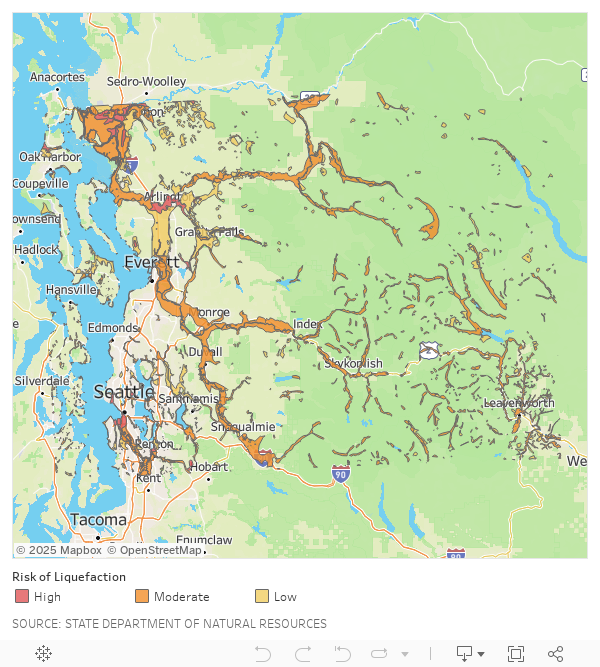
An estimated 30,000 to 50,000 residents in Snohomish County live in places designated by the county as moderate to high risk for liquefaction, according to an analysis by The Daily Herald. The majority of those homes are in Monroe, Lake Stevens and Snohomish, as well as along the Mukilteo and Edmonds waterfronts. Much of Arlington, Darrington, Sultan and Gold Bar also are in areas of moderate to high threat.
About 20,000 parcels are in the volatile zones. That’s about 7% of the county’s lots. More than 100 are along the Everett waterfront and on the U.S. Navy base there.
With modern engineering and construction standards, some experts say, new buildings on those vulnerable soils can be as safe as those on solid ground. However, building in those precautions comes at a steep cost for developers.
In Everett, some of the most enviable property within sight of Puget Sound sits on land almost sure to become squishy and unstable in a large quake.
SeaLevel Properties is building more than 200 apartment units within a few miles of the subterranean southern Whidbey Island fault’s invisible path beneath Puget Sound.
“They’re not making any more waterfront and everyone wants to live on the water,” said Kyle Weeks, SeaLevel director of multi-family development.
“Something like liquefaction is a hurdle to get over,” Weeks said. “But it doesn’t make the site unachievable to build there.”
Buildings from the 1970s and earlier, however, were erected before code required seismic reinforcement. If a severe earthquake strikes along the Whidbey fault, many older buildings would crack, tilt and sink into the ground as it softens and vibrates.
On a Snohomish County seismic hazard map, shades of orange and red highlight strong potential for land to liquefy along rivers, beaches and muddy lowlands. Those danger zones overlap with critical pipes carrying water from mountain reservoirs to thousands of faucets in Snohomish County. If those pipes fracture, running water could be cut off indefinitely, perhaps for more than a year, former county Public Works Director Steve Thomsen said.
Other key pieces of infrastructure, like highways and railroad tracks, occupy some of the most vulnerable land in Western Washington. Severing I-5 in just one place could grind traffic and a local economy to a standstill, as the 2013 Skagit River bridge collapse showed.
Multiply that by many other bridges in a far more populated county.
Only in the past three decades have experts begun to understand the devastation that could be unleashed by an extreme quake along the southern Whidbey Island fault. What we still don’t know is when the next one will strike.
It could be at any moment.
In the pudding
As her breath puffed in the crisp winter air, Jody Bourgeois pointed to a mound of steaming wood chips along the tidal sloughs that snake through Everett like veins.
Bourgeois, a sedimentary geologist, had returned to revisit the evidence she found of a historic Cascadia Subduction Zone earthquake, when she studied the Snohomish River delta in the late 1990s at the University of Washington.
Piles of wood chips and compost belong on the delta, not houses and highways, she said. One slough is flanked by two of the county’s major thoroughfares, Highway 529 and I-5. Everett’s wastewater treatment plant lies to the east, beside the marsh grasses and scraggly gray trees of Spencer Island Park. Carved by the migrating river, the delta is made of peat, mud and a base layer of sand. In a quake caused by the southern Whidbey Island fault, all three layers could liquefy.
An earthquake can turn silty, loose soil into quicksand. Grains vibrate against each other. Like shaking up a soda bottle, then cracking the cap, the ground erupts with geysers of water and sediment in a pressure overload. Geologic evidence suggests a local, shallow rupture of a magnitude 7 or greater along the Whidbey fault would generate even more liquefaction than a major Cascadia Subduction Zone earthquake, at least in the Everett region, Bourgeois said.
In a severe Whidbey fault quake, Union Slough’s banks would melt into the water the way cake batter flattens as you shake the pan. Roads would crack. Sand would ooze from openings like slowly erupting volcanoes. Water would seep through the asphalt. Bridges would fracture as the land turned soft around them.
Over the past three years, the Riverfront development in Everett has created two new neighborhoods along the Snohomish River, with hundreds more homes permitted for a third parcel, a marshy field next door.
Generally, that’s the kind of ground susceptible to liquefaction, Bourgeois said.
The risk is much the same on other land along the Snohomish and Stillaguamish rivers, near Quilceda Creek and bordering Puget Sound, according to county disaster experts.
After a drive to Everett’s marina, Bourgeois gazed up to the bluff where Grand Avenue Park is nestled in a neighborhood of houses and apartments.
“If people up there are on a cake,” Bourgeois said, “then people down here are on pudding.”
Allan Giffen, a retired Everett planning director, crafted the development requirements for geologically hazardous areas of Everett in the 1990s, as required by the state’s Growth Management Act.
Today, most jurisdictions have much better data. As geologic surveys clarify the risks of natural disaster in Snohomish County, local standards evolve.
“The geology hasn’t changed,” Giffen said. “But our ability to understand it has.”
Hot spots for liquefaction in Everett include the city’s deep-water marine terminal and everything west of West Marine Drive, Giffen said. The waterfront used to be mud flats, like those visible from the picnic tables at Legion Memorial Park’s overlook. The Port of Everett used fill — loose, sandy soil — to turn the flats into a waterfront long-dominated by sawmills.
It’s a perfect recipe for liquefaction. It’s also the site for 266 new luxury apartments.
The price of safety
People want to live within sight of the Pacific Northwest’s wild rivers and scenic shores, despite the inherent hazards.
“What makes it dangerous is what makes it beautiful,” said county Planning and Development Services Director Barbara Mock, who retired in April.
As a general rule, the county discourages people from building along rivers — on muddy, liquefaction-prone soils — by prohibiting or limiting residential development. Those locations also require cost-prohibitive flood insurance.
“What they can and can’t do is very regulated,” Mock said.
The International Building Code dictates how developers mitigate liquefaction.
[Local earthquakes: Where to learn more and how to prepare]
Usually it requires pilings driven through looser soil to penetrate solid ground, Giffen said. Those columns may reach down 70 feet or more to become firmly anchored.
At the marina, SeaLevel has two multi-family residential buildings, with 1,924 pilings.
The design assumes that a retaining wall built by the Port of Everett would fail in a major earthquake.
The engineers “felt it wasn’t designed to their standards,” said Weeks, of SeaLevel.
If the port’s retaining wall were to fail, much of the fill along the waterfront could slide into Puget Sound.
So in addition to the vertical underground columns, SeaLevel added a series of horizontal steel pilings that interlock against the sideways force of a potential retaining wall breach.
Today’s building codes are designed to protect lives in an earthquake. Developers shell out millions to prevent buildings from collapsing, but those structures may not emerge entirely unscathed after a major event, Weeks said.
var divElement = document.getElementById(‘viz1621029624843’); var vizElement = divElement.getElementsByTagName(‘object’)[0]; if ( divElement.offsetWidth > 800 ) { vizElement.style.width=’600px’;vizElement.style.height=’667px’;} else if ( divElement.offsetWidth > 500 ) { vizElement.style.width=’600px’;vizElement.style.height=’667px’;} else { vizElement.style.width=’100%’;vizElement.style.height=’727px’;} var scriptElement = document.createElement(‘script’); scriptElement.src = ‘https://public.tableau.com/javascripts/api/viz_v1.js’; vizElement.parentNode.insertBefore(scriptElement, vizElement);
“It’s really to keep your occupants safe, not to keep your asset safe,” he said.
Steve Kramer, a professor emeritus of civil engineering at the University of Washington, might be the most prominent liquefaction expert in Seattle. He lectured on the subject at UW for almost 40 years, and he played a large role in research that showed the Alaskan Way Viaduct along Seattle’s waterfront wasn’t seismically sound. It was demolished and replaced by a tunnel.
With today’s engineering, Kramer said, soils prone to liquefaction don’t have to be off limits for residential construction, as long as developers are willing to spend.
“We have the ability to make structures in liquefiable soils as safe as structures that are not in liquefiable soils,” he said. “But it costs money to do that.”
The liquefaction-proofing on the Everett waterfront cost SeaLevel about $2 million.
Snohomish County and the City of Everett follow the same procedure for permitting a building in seismically hazardous areas.
Someone looking to build on highly liquefiable land most likely must hire a third party for a geotechnical report. Government staff review the expert’s report to ensure it meets the International Building Code. The code requires on-site observation by the geotechnical engineer for certain commercial projects.
A planned 1,250 apartments, a movie theater, a grocery store, retail and restaurants going in along the Snohomish River, east of downtown Everett, would also sit on soil highly likely to liquefy in a Whidbey fault earthquake.
Those buildings will be supported by pilings driven 50 to 85 feet through layers of unsteady susceptible delta soil and the detritus of a former landfill, said Eric Evans, director of development at Shelter Holdings.
The riverfront project will require 750 to 800 piles. The cost of piling, Evans said, typically adds about 30% to the cost of building a foundation.
Some jurisdictions, including the City of Seattle, have added protections on top of what the International Building Code requires, because of the potential for a megaquake.
Seattle grew into a city atop a sedimentary basin — a depression filled with soft sediment rather than rock. The basin amplifies shaking in an earthquake, especially in high-rise buildings. The city’s geotechnical department started asking builders to consider the increased impact of basins starting in 2010, and the city formally adopted extra provisions in 2018.
“These regulations make the buildings stronger so they are able to withstand the increased motions you might expect in a basin,” Geotechnical Engineering Group Supervisor Susan Chang said.
Basin amplification mostly impacts skyscrapers. So Seattle’s code applies only to buildings over 240 feet. The effect is less on shorter buildings, Chang said. The increased requirements in Seattle mean developers need to spend more to make the buildings stronger.
“It’s a meaningful amount,” Chang said. “It’s not something they can just brush off.”
Snohomish County has its own sedimentary basin. The Everett Basin is centered under Hat Island in Possession Sound and extends northeast to Marysville and Granite Falls, and west past Whidbey Island. It’s not as deep as the Seattle basin but still has the potential to magnify shaking.
The next update to the International Building Code will mandate protecting against basin amplification, UW geophysicist Erin Wirth said. But that code could take years to roll out.
Some critical infrastructure was built before such codes existed. Most of Everett’s Water Pollution Control Facility on Smith Island, for example, was built in the 1960s. Back then engineers didn’t know about the existence of the southern Whidbey Island fault, or even the Cascadia Subduction Zone.
In a Whidbey quake, most of the water treatment building could hold up. But pipes would break, spewing sewage into the river and Puget Sound.
“When you take a community, stick it inside a jar and shake it up, you have a lot of toxic stuff floating around in the water and on the ground,” said Thomsen, the retired county public works director. “Everything breaks, everything falls apart and mixes together, and that’s a mess.”
A year without water?
About 410 miles of pipes deliver water to Snohomish County. Only about 1 mile has been outfitted with earthquake-resistant material.
After a quake on the southern Whidbey fault of, say, magnitude 7.4, getting water back to taps could take a year or more, Everett Public Works Principal Engineer Souheil Nasr said.
Everett Public Works controls the main pipes that bring water down from the Cascade foothills and then supplies it to about 75% of Snohomish County. These are the familiar, giant blue-green pipes running parallel to the U.S. 2 trestle. They end at two holding tanks in Everett: one on Rucker Hill and one off Evergreen Way near the Everett Golf and Country Club. Along the way, water is routed underground to treatment plants and, finally, to homes.
The pipes could snap in hundreds of places in an earthquake. Public Works could still get water to reservoirs through the reinforced pipes. They would act as water stations where people could bring containers to fill and take home.
There are flaws in that plan.
One of the reservoirs on Rucker Hill is over 100 years old. As of now, it would probably fail in a major earthquake, Nasr said. The other is 60 years old. The roof would likely cave in during the shaking. If both failed, Public Works would have to manually extract water from the main pipes.
“That’s not sustainable,” Nasr said. “It’s on an emergency basis, and I’m not sure how long that will last for.”
The City of Everett is seeking to remedy that. The city is replacing the roof at the Evergreen Way reservoir, and it should be completed in early 2023. A design for the Rucker Hill reservoir is also in the works. An $18 million project is to begin this year.
As for the rest of the pipes throughout the county, “money is an issue,” Nasr said.
Over the next 10 years, the city has budgeted $46 million to reinforce water infrastructure. That includes creating a backbone in the pipes that can withstand a southern Whidbey quake.
Other utilities have better odds.
The Snohomish County Public Utility District modeled a magnitude 7.4 earthquake and found that about 87,000 customers could lose power. That’s around 25% of consumers, concentrated in the central and southern areas of the county.
PUD spokesperson Cayle Thompson said about 80% of those outages could be restored within three days after such an earthquake, and almost 100% of customers within a week. That would leave most residents better off than in a bad windstorm, which can knock out 60% of customers’ power. PUD officials stressed that those figures were based on one training scenario, and that there really is no way to foresee the damage.
No earthquakes have caused widespread liquefaction in Puget Sound in recent history, but we can look to New Zealand for a glimpse of what could be in store. In 2011, a magnitude 6.3 earthquake throttled the large coastal city of Christchurch, causing extensive liquefaction, killing 185 people and injuring thousands. The quake destroyed over 80% of the city’s downtown. Thousands of smaller aftershocks struck in the months that followed.
Five years later, thousands of New Zealanders were still waiting to have their homes rebuilt or repaired.
Today, nature has mostly reclaimed a swath of land where 8,000 homes once stood two miles from downtown Christchurch. The New Zealand government deemed the expanse uninhabitable in 2012 due to earthquake risk.
Band-Aids
Imagine the aftermath one full day after a southern Whidbey Island fault quake.
Time between aftershocks increases from minutes to hours.
Everett’s Angel of the Winds Arena is transformed into an emergency shelter. Over 600 people wait in the stands or on blankets covering the arena floor. Others take refuge at Everett Community College and Forest Park.
Laborers are left to un-bury cities from mountains of rubble. County bulldozers clear key roads first: I-5, U.S. 2 and other highways. State transportation workers begin to create passages around crumbled overpasses.
But these are Band-Aid fixes. Snohomish County’s mangled infrastructure and highways won’t fully recover for years.
Herald reporter Joseph Thompson contributed to this story.
Julia-Grace Sanders: @sanders_julia on Twitter
Read the rest of this series
1. Buried danger: A slumbering geologic fault beneath us
An earthquake along the southern Whidbey Island fault reshaped the land some 2,700 years ago. Another big one is expected, and it could be devastating. READ MORE
2. Built on pudding: Can modern quake engineering prevail?
At least 30,000 people in Snohomish County live on saturated soils and sediment that will behave like shaken liquid when a big earthquake hits. THIS STORY
3. Aftermath: Infrastructure won’t fare well in a big quake
Shockwaves from a shallow fault here could ravage bridges, schools and the water supply in Western Washington. Emergency planners want you to be ready. READ MORE