Early maps of legislative districts endanger some incumbents
Published 1:30 am Wednesday, September 22, 2021

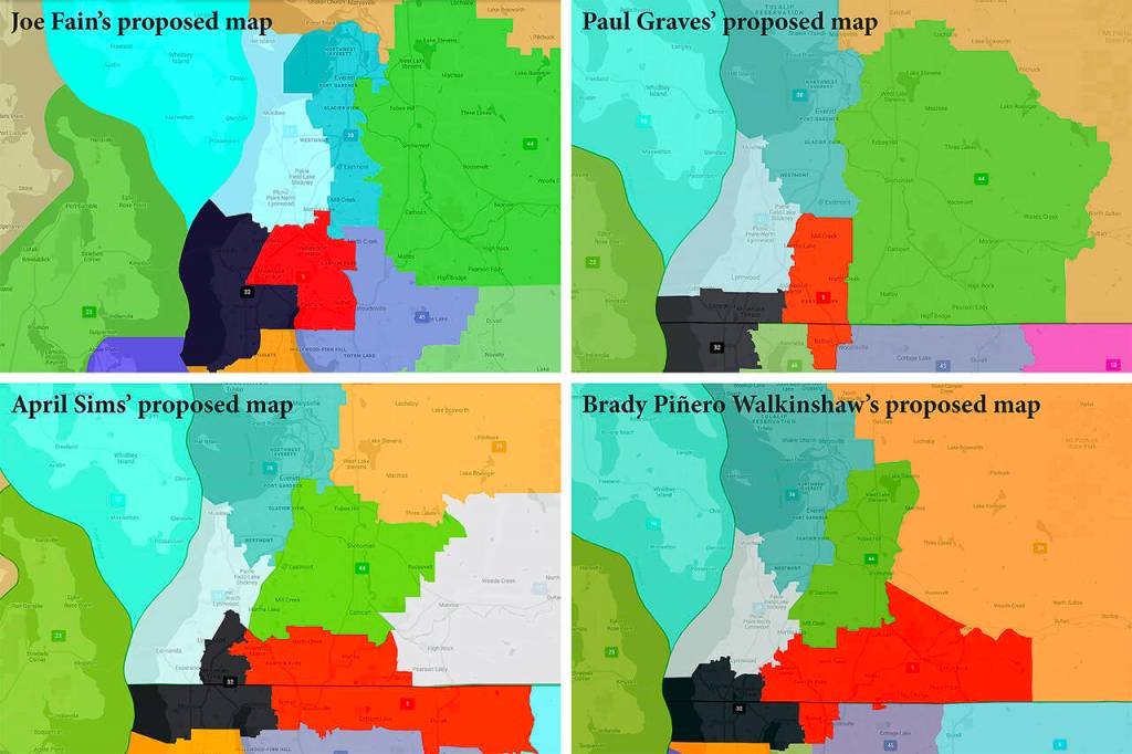


OLYMPIA — The once-a-decade realignment of legislative boundaries kicked into gear Tuesday with release of four approaches to redrawing the lines of Washington’s 49 districts.
Those proposals could bring big changes for some Snohomish County communities, and big challenges for incumbent lawmakers.
On Tuesday, each of the state Redistricting Commission’s voting members — Democrats April Sims and Brady Walkinshaw Pinero and Republicans Joe Fain and Paul Graves — released a map showing how they would reset the boundaries.
It didn’t take long to see there are big cartographic and political wrinkles to iron out before a Nov. 15 deadline to adopt a final map, which will be in place for the 2022 elections.
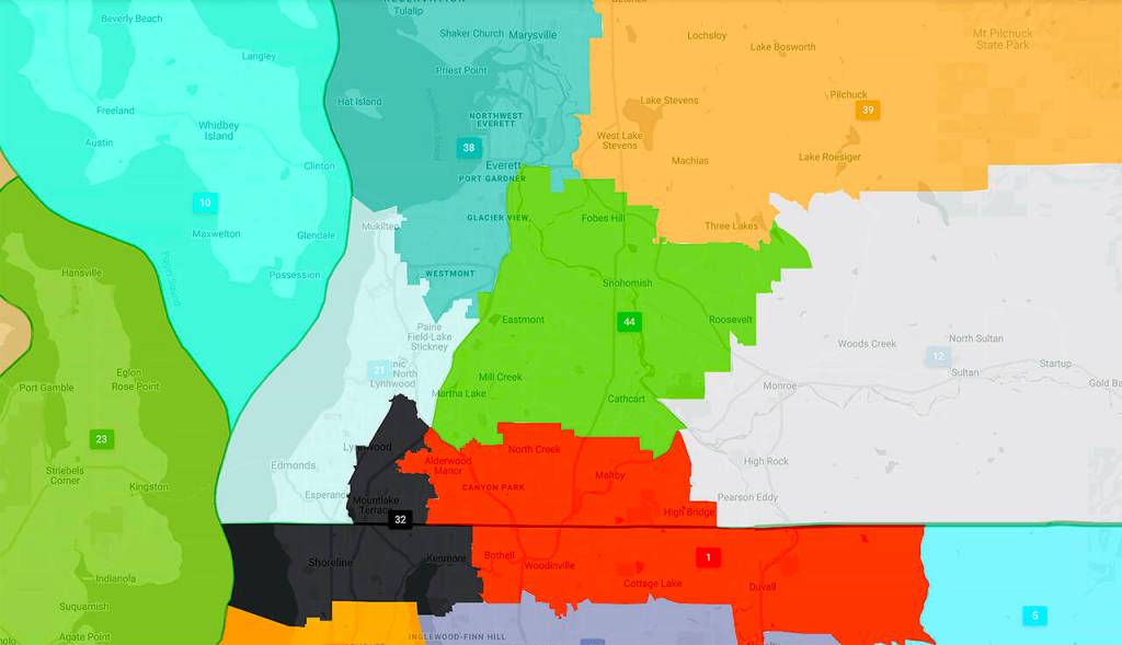
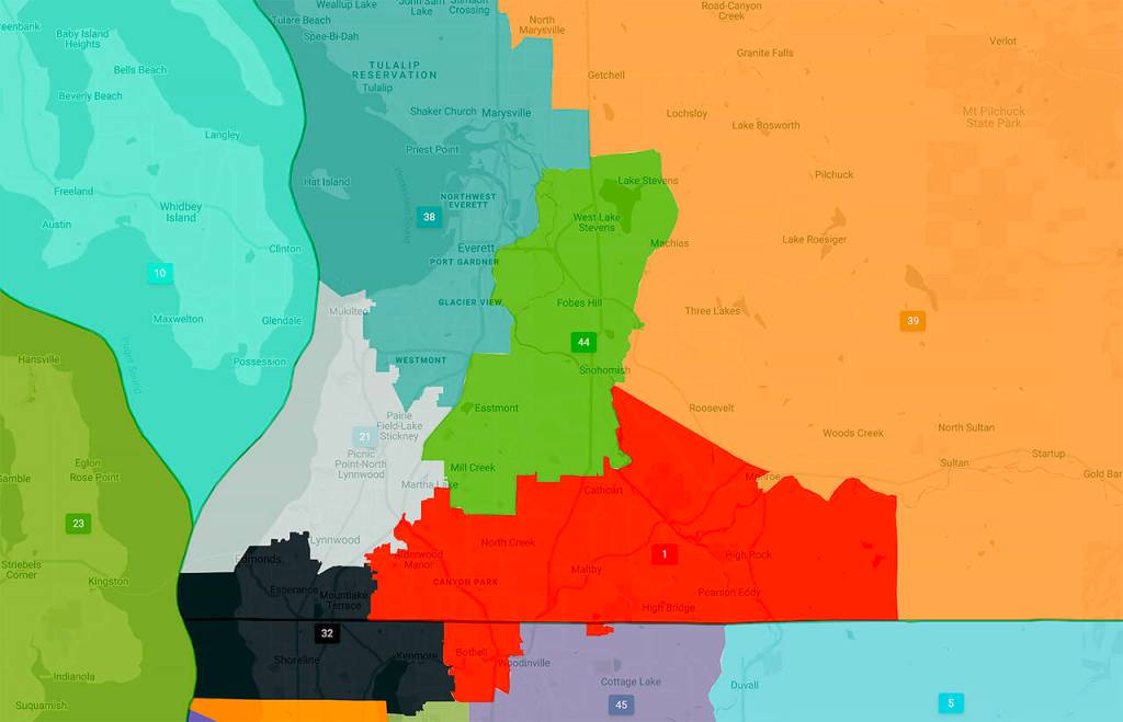
The fate of Mill Creek — home of Democratic Reps. John Lovick and April Berg — is one example.
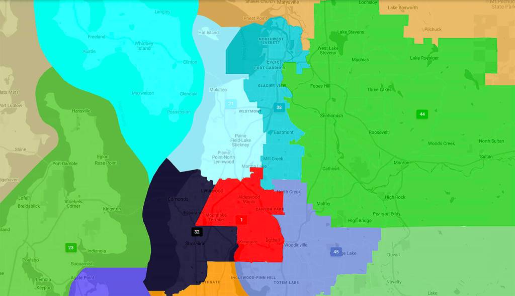
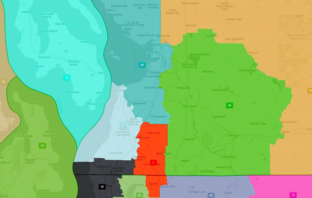
Democratic commissioners keep it in the 44th Legislative District. Republicans don’t. Graves moves it south into a reconfigured 1st District, while Fain joins it with Everett in the 38th District. Either of those latter scenarios could force Lovick and Berg to compete against other Democrats to continue serving.
Every 10 years, after the U.S. Census, the boundaries of the state’s legislative and congressional districts are redrawn by a bipartisan commission. Similarly, and simultaneously, a local panel follows the same process to redraw the five Snohomish County Council districts.
Under state law, updated boundaries must create districts nearly equal in population, as compact as possible, of geographically contiguous areas and not favoring or disfavoring any racial group or political party. The new districts should also coincide with existing natural boundaries and preserve communities of related and mutual interest.
Regarding legislative districts, all four commissioners touted their efforts to keep tribal communities united in single districts and increase the number of majority-minority districts in which a majority of the population is non-white.
Achieving those goals while equalizing population in 49 districts isn’t easy, especially when so much of the population growth the past decade occurred on the west side of the state.
“The biggest question for me was where would we get population for eastern Washington,” said Sims, who is secretary-treasurer of the Washington State Labor Council.
She did it partly by uniting a swarm of communities along U.S. 2 — from Monroe east to Leavenworth and Wenatchee — into a retooled 12th District. Sims said she focused on keeping communities of interest together.
“One district had to cross the Cascades,” she said. “This was where we started. This is what made most sense.”
Sen. Steve Hobbs, D-Lake Stevens, and Sen. Keith Wagoner, R-Sedro-Woolley, find themselves in new political regions under another part of Sims’ proposal.
She shifts Lake Stevens from the 44th District into the 39th, a solidly Republican district the past two generations. Meanwhile she moves Sedro-Woolley out of the 39th and into a redesigned 40th District that runs up to the Canadian border. The district’s current representatives are Democrats.
Sims also retools the 10th District into an all-island district, combining Whidbey and Camano Islands with the San Juan Islands.
“The lines on the map as I’ve drawn them today will change as a result of negotiation,” Sims acknowledged. “But what won’t change is the value that I am bringing to this process.”
Fain, a former state senator, said he constructed his map with an eye to keeping school districts entirely within the same legislative district.
“Making public schools the center of gravity for our legislative boundaries will elevate the voices of students, educators and parents in state government,” he said in a statement. “There is no more important community of interest than those bound together by our public schools.”
He estimated 32 school districts across the state will no longer be split by districts, “giving them a stronger voice with their representatives.” One of those is the Everett School District as his map moves Mill Creek, which is part of the school district, into the 38th.
Another goal was to increase the potential for greater electoral competition. He estimated his map would increase the number of swing districts — those in which voters elect candidates from both parties — from 11 to 15.
“Competitive elections keep representatives accountable to their local communities rather than partisan interests,” he said. “It is crucial to the democratic process that our maps reflect that.”
Both Fain and Graves, also a former state lawmaker, are proposing an eye-catching idea of combining Bainbridge Island with parts of Seattle.
Graves said he also sought to create districts more apt to generate electoral competition — and not protect incumbents.
“These are maps for representatives of 7 million Washingtonians and not the 147 people who hold those jobs now,” he said.
But Tina Podlodowski, chairwoman of the state Democratic Party, issued a statement criticizing the GOP offerings.
“The job of the Commission is to respect communities of interest, public comment, municipalities and counties, and not the GOP’s political objectives,” she said. “Maps that don’t follow the statute aren’t pursuing competitiveness, they’re gerrymandering. The GOP commissioners should go back to the drawing board and try producing maps that respect the law.”
Graves sharply disagreed.
“We want to have a lot of competitive districts and Democrats want to have none,” he said.
Commissioners will hold a virtual public hearing on the proposed maps at 7 p.m. Oct. 5. Additionally, comments on the proposed maps can be submitted in any language via the “How to Participate” page on the commission’s website at www.redistricting.wa.gov.
And the public is encouraged to submit their own proposals using the commission’s online mapping tool.
Commissioners will release their congressional district maps Sept. 28.
Jerry Cornfield: jcornfield@heraldnet.com; 360-352-8623