Granite Falls group urges preservation of bridge slated for demo
Published 1:30 am Saturday, December 11, 2021
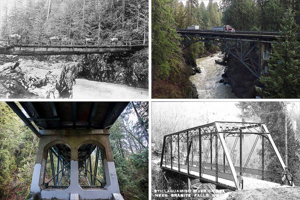

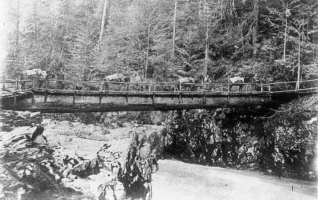
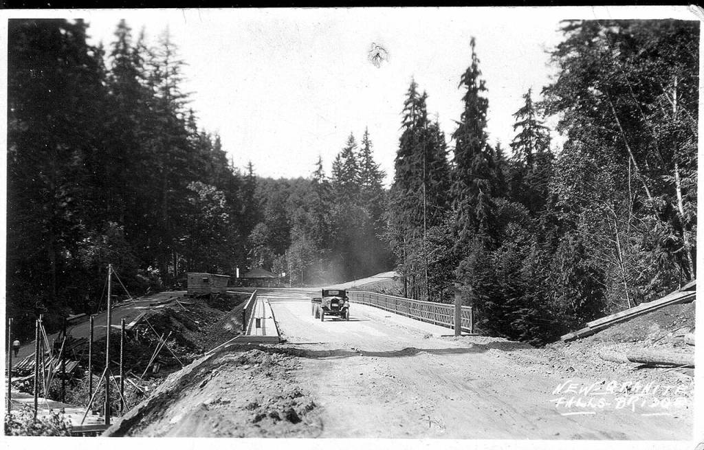


GRANITE FALLS — Over a century ago, an enormous log and some rope helped people cross the South Fork Stillaguamish River.
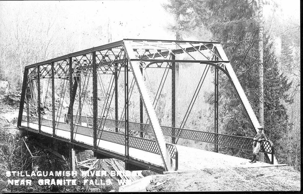
As logging and mining boomed east of the gap, a steel bridge replaced the log in 1911.
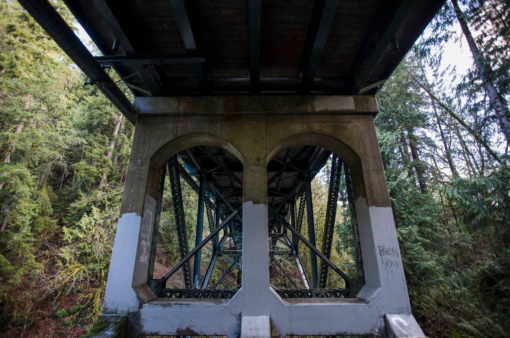
Today, thousands of drivers every year cross the towering concrete and steel span built in 1934.
At 87 years old, the structure, officially called Granite Falls Bridge 102, has held together remarkably well.
“It’s a testament to the engineering that went into it,” said Fred Cruger.
Cruger is the treasurer of the Granite Falls Historical Society and a member of the city’s planning commission.
He wants to save the bridge and turn it into an overlook reserved for pedestrian and emergency access.
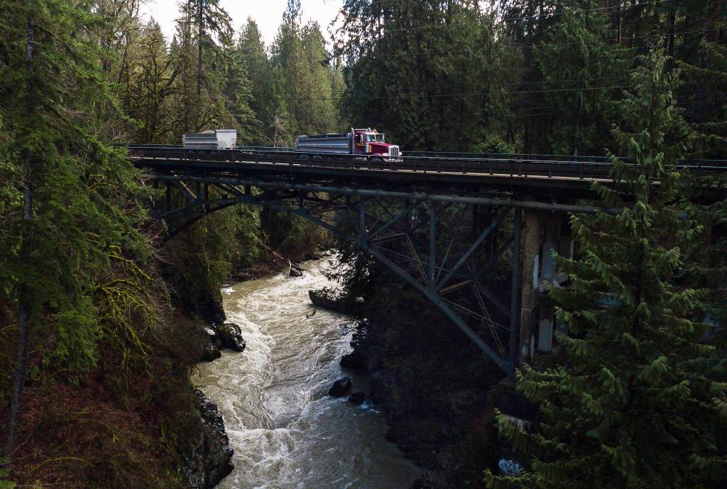
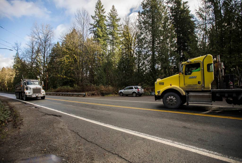
For decades it has been a vital connection along the Mountain Loop Highway, averaging 750 freight trucks loaded with gravel, lumber and soil every day. That’s about 14% of daily traffic, Snohomish County Public Works Director Kelly Snyder said.
But county staff say the bridge has outlived its “design life” of 75 years.
“We’ve done a really good job of maintaining it beyond that life expectancy,” Snyder said.
At this point, the bridge is slated for demolition after a new one is built around 2025, but the decision is not final.
Keeping the old one, and its liability and risk, would require federal approval and consultation with area tribes and other agencies, Snyder said. If it was kept, the cost of long-term maintenance or future removal “could fall entirely” on county taxpayers, she said.
Snohomish County Public Works applied eight times for federal grants to replace the bridge.
Last month, the U.S. Department of Transportation’s Rebuilding America’s Infrastructure with Sustainability and Equity (RAISE) grant program awarded the project just over $22.1 million.
The total estimate for the replacement is $28.7 million, with county road funds covering the difference.
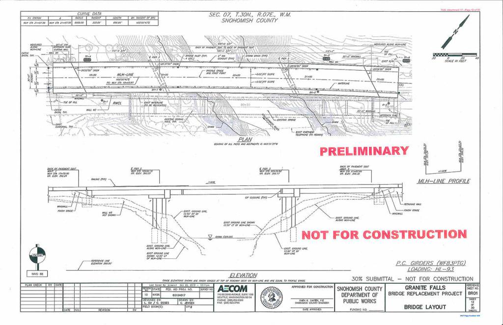
Structurally, the existing bridge is sound. It spans 340 feet with two 10-foot-wide lanes, and it stands about 97 feet above the river.
Even after some major earthquakes in the region, inspections didn’t reveal critical damage, county engineer Doug McCormick said.
Bridge inspections cost about $5,500 every other year. A special truck with a bucket crane is contracted, in partnership with the Washington State Department of Transportation.
Workers paint the bridge every 20 or 30 years to preserve the metal. It last happened about a decade ago and cost just over $1 million. Painting the smaller Red Bridge, also on the Mountain Loop Highway, is estimated to cost $2 million.
Otherwise, maintenance is part of daily road work along the Mountain Loop Highway and not a major expense, McCormick said.
Instead, modern vehicle width and the narrowness of the vehicle deck have made it obsolete. Trucks have to take turns crossing.
“I think it’s known by all the drivers that it’s a narrow structure that they need to take care of when driving across,” McCormick said.
Designs for the new bridge call for it to be 406 feet across, 30 feet wide, and just downstream of the current structure. Sidewalks of 5 feet are planned for each direction.
Normally the water below is a milky blue, though since work upstream this summer it has been a bit more brown.
When it rains, the river surges down the city’s namesake falls. The sound roars off the sheer rock wall across from where people can watch the fish ladder that helps salmon charge upstream.
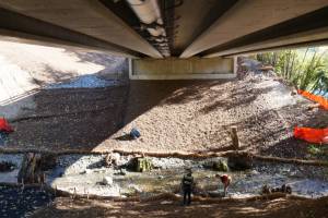
A small trail leads down to the underside of the bridge and down a steep path to the river. On a recent visit, brown and yellow leaves covered the damp ground, with cedar trees all around.
“You get a real feel for the river, the falls, the beauty of it all,” said Tom Thorleifson, a Granite Falls Historical Society member and retired teacher.
In 2018, demolition was estimated to cost $1.3 million, the county engineer said.
But Cruger and other local historians say that’s a mistake and a missed opportunity.
He sent former U.S. Transportation Secretary Elaine Chao a letter in 2019 supporting the replacement bridge. His letter also asked for the existing span to be saved.
Should the bridge be closed, a detour through Darrington is about 90 miles.
“It would be a much safer pedestrian and bicycle crossing,” Cruger said. “I would rather see the tourism, the historical and cultural elements of those items enhanced, rather than detracted by the new bridge.”
The county’s current plans call for cyclists to use the 15-foot travel lanes on the new bridge, which would be built just west, or downstream, of the existing one. About 400 feet of new road to the new bridge could displace some parking near the fish ladder.
Snohomish County staff plan to add spaces on the east side of the highway. To help people safely reach the fish ladder without crossing the highway, the county is considering a pedestrian path underneath the bridge.
Once the new bridge is built, the downstream view will likely be obstructed.
“If somebody were to walk out on the old structure and look out on the side, they’re going to see the side of a girder,” said McCormick, the county engineer.
But nothing is yet set in stone.
The bridge’s potential eligibility for the National Register of Historic Places would be considered during the federal environmental assessment, which includes public comment.
Until then, people can stay informed by visiting the county’s project website at bit.ly/3Gr2Neb or signing up for email alerts.
Ben Watanabe: bwatanabe@heraldnet.com; 425-339-3037; Twitter @benwatanabe.
Correction: An earlier version misstated the cost for bridge inspections.