Finally, rain in the forecast for Western Washington
Published 6:00 pm Monday, October 17, 2022


INDEX — After a weekend of record-breaking high temperatures and heavy wildfire smoke, Western Washington can expect rainfall and marine winds to bring relief toward the end of the week.
On Friday, a rainstorm is forecast to blanket the central Puget Sound and North Cascades, followed by lighter showers Saturday and another weather system bringing heavy rain Sunday. The rain is expected to be more than the region has seen in the past four months combined, said Trent Davis, a meteorologist for the National Weather Service of Seattle. Since June 10, Davis said the region has seen less than an inch of rain.
“In that time, based on a 30-year average, normally we would have picked up roughly 5 inches,” the meteorologist said. “To go since June with no big rainfall — that’s pretty impressive for that length of time.”
Temperatures in the region broke records over the weekend for the hottest this late in the year. The high recorded Sunday at Seattle-Tacoma International Airport was 88 degrees, blowing away the previous record high of 72 degrees set in 2018.
The “much-needed” rainfall in the forecast means weather will finally start looking like what we usually expect for fall in this area, Davis said.
On Monday, wildfires continued to burn in the North Cascades. The Bolt Creek wildfire was estimated at 14,208 acres with 41% contained as of Monday afternoon. A stretch of U.S. 2 near Skykomish was blocked off multiple times over the weekend because of that fire.
U.S. 2 remained open Monday, but authorities said the highway could be closed again if debris from wildfires falls into the road. Road closure updates were posted on the fire’s incident command page.
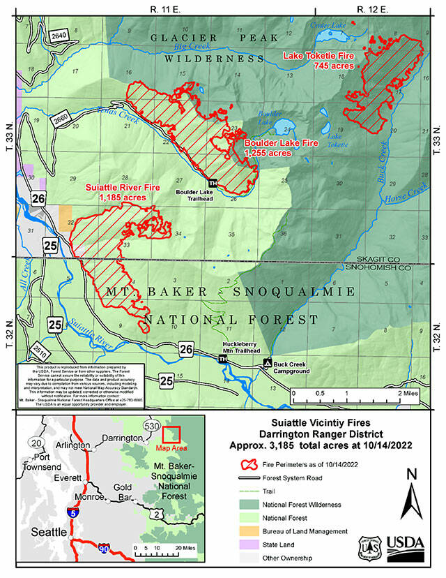
The Suiattle River and Boulder Lake fires burning in the Mount-Baker Snoqualmie National Forest both tripled in size over the weekend, burning 3,800 acres each as of Monday. The two fires east of Darrington were 0% contained that afternoon.
A fire erupted Sunday south of Oso and was estimated to burn about 8 acres of land near the Jim Creek Naval Station, Davis said.
Critical infrastructure at the base was protected, according to authorities at North County Fire. No cause had been announced as of Monday.
Last week, the Loch Katrine fire broke out in the Mount Baker-Snoqualmie National Forest 30 miles east of Seattle. By Monday afternoon, the fire had quadrupled in size in the span of 24 hours. It was estimated at 7,500 acres with 2% containment.
An off-duty NWS employee captured multiple ongoing wildfires from a flight today. Based on our determination, it appears Loch Katrine is in the foreground, Bolt Creek in the middle, with the Suiattle River fire in the background. #WAwx pic.twitter.com/kdxLBpSoYh
— NWS Seattle (@NWSSeattle) October 16, 2022
Heavy wildfire smoke shrouded much of Western Washington on Saturday. The smoke was expected to stick around for a few days.
On Monday, the National Weather Service issued a hazard alert for air quality in Snohomish County, in effect through Thursday. Air quality was forecast to remain or become unhealthy for sensitive groups. Air quality could be especially poor in the valleys of the Cascade Range.
“It looks like the smoke will just kind of hang around in the area until we get that push on Friday, with more westerly airflow from the Pacific,” Davis said. “Air quality is going to be waffling around the next few days, so it will be worse at certain times in certain areas.”
In Index, Mayor Norm Johnson said air quality got bad over the weekend, but it was better by Monday afternoon. He said the wind seemed to be blowing more clean air from the southwest, as opposed to smoky air from fires burning north and east of town.
“The air quality today is pretty good,” Johnson said. “It’s the first time I’ve actually been able to see to Heybrook Ridge — I can see the fire smoldering and smoke coming out of the trees on the very tippy-top of the ridge there.”
Johnson said some Index residents grew increasingly concerned over the weekend.
“We went back to a Level 1 (‘be ready’ evacuation warning) on Friday, and people were concerned because winds were blowing towards town,” he said. “Luckily they were very mild winds. But some folks were concerned the winds would continue to blow the wrong way in our world.”
The National Weather Service advised people in areas with unhealthy air quality to minimize spending time outside.
The Washington Smoke Blog provides a map with live updates of air quality throughout the region.
Ellen Dennis: 425-339-3486; ellen.dennis@heraldnet.com; Twitter: @reporterellen.