What geologists learned from Oso, and what they wish they knew in 2014
Published 2:00 pm Tuesday, March 19, 2024


OSO — Geologists weren’t shocked when a landslide broke loose near Steelhead Haven in 2014.
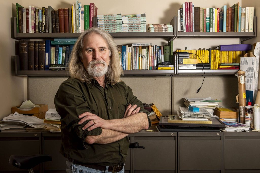
“But I think people, including most geologists, were pretty surprised that so much of that mountain went so far so fast,” said University of Washington geomorphologist David Montgomery.
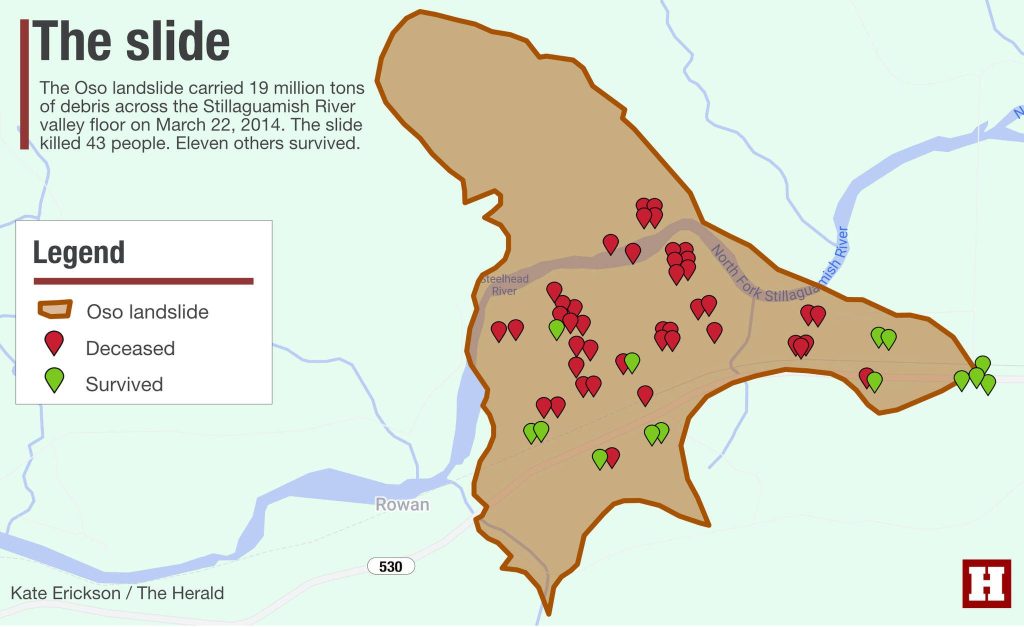
Ten years ago, on the morning of March 22, 2014, the 650-foot-tall hill collapsed above the neighborhood, engulfing the community in 19 million tons of sand, clay and timber. The landslide traveled about a half-mile across the Stillaguamish River valley floor.
In the blink of an eye, it killed 43 people.
“The analogy we often use is kind of like an air hockey table,” said Brian Collins, a U.S. Geological Survey civil engineer. “Instead of the landslide just stopping when it got to the flat areas, it just kept going. It just kept sliding right on out.”
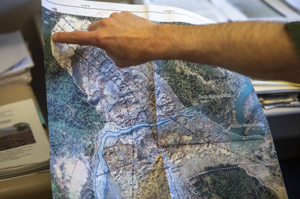
The Highway 530 slide has become a landmark case for geologists who analyzed the disaster in the days, months and years that followed. Collins helped members of the search and recovery team in the aftermath. He also led studies that explored the slide’s speed and distance, which had stumped experts.
The hill was perched above an “alluvial valley,” or an area filled with loose, saturated sediment, Collins said. The groundwater table was high after weeks of rain. So when a large mass hits a saturated area at a high speed, sediments become pressurized. U.S. Geological Survey research indicated the Oso slide had an average speed of 40 mph.
Several landslide experts said the tragedy near Oso led state and national officials to put more funding into mapping landslide hazards. Doing so, geologists said, can help people better prepare for these natural disasters.
‘An acceptable risk’
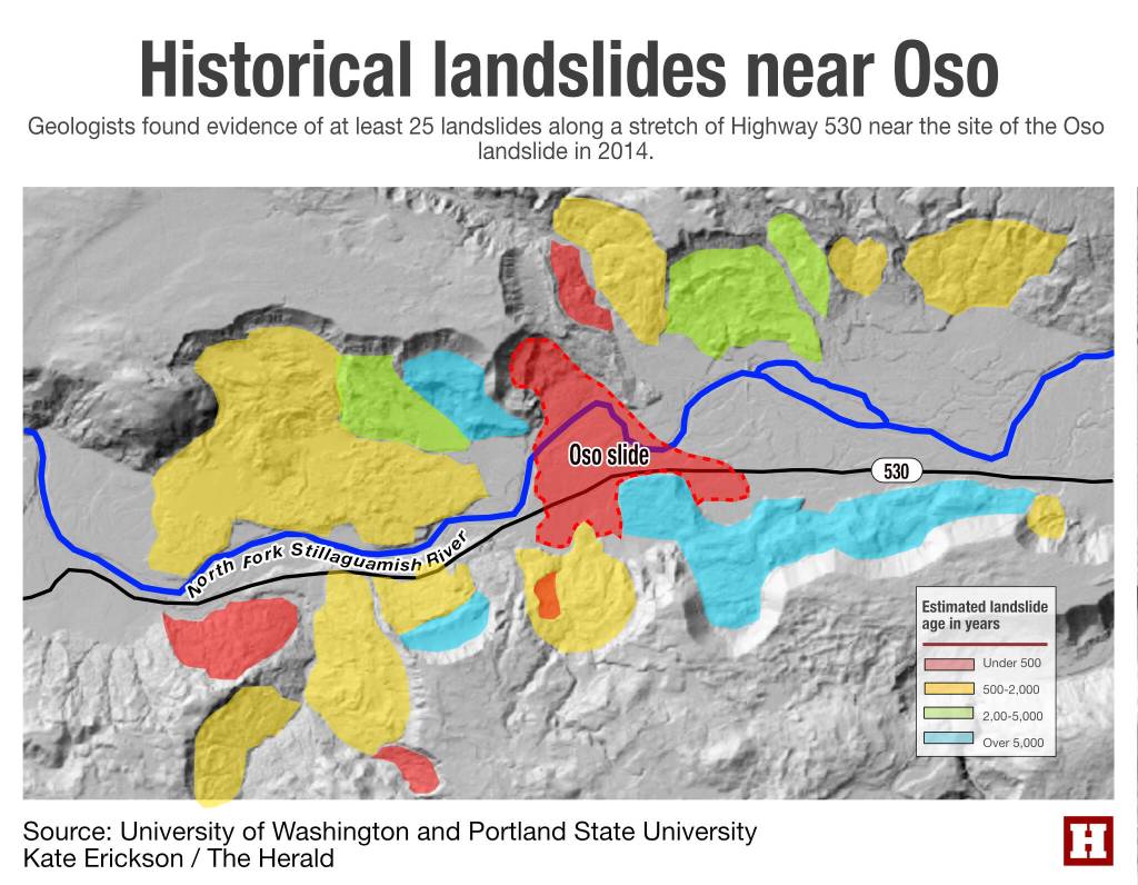
At least 25 major landslides spilled into the valley near the Oso site before 2014, and at least seven left geological evidence over 5,000 years ago.
Roughly 10 slid between 500 to 2,000 years ago.
And five landslides struck the corridor in the past 500 years, according to a 2016 study.
In 2006, the “Hazel Landslide” traveled over 300 feet and stopped before hitting the Steelhead Haven neighborhood. The same slopes would reactivate in the Oso landslide eight years later.
Snohomish County Planning and Development Services staff are responsible for managing development in the region. The county’s land-use restrictions at the time required structures to be at least 300 feet away from potential landslide hazards.
All of the structures demolished in the Oso slide were more than 300 feet away from the “toe” of previous slides, so they weren’t subject to county code.
“You’ve got to be able to forward-predict how is this going to behave, and where is it going to go,” Montgomery said. “And that is still a key weakness in almost almost every local jurisdiction, and states’ landslide hazard planning: They will map the landslides, but not predict where they would go.”
Numerous studies aired warnings about the slope in Oso.
Notably, geologist Gerald W. Thorsen wrote in 1969 that “major construction below any of these old scarps should be done with extreme caution.”
The county’s hazard assessments and mapping 10 years ago would not have raised concerns among Steelhead Haven residents, Montgomery said. And they still might not if the Oso landslide happened today.
“I doubt most of them knew about the various reports that had been done at the state level over the years about the hill across the river from them,” he said.
Large landslides have reoccurred roughly every 400 to 1,500 years in the vicinity of Oso, according to the Geotechnical Extreme Events Reconnaissance, or GEER report, conducted after the slide. Experts offered theories on what ultimately ignited the Oso landslide, but Montgomery said, “it’s not up to scientists to decide what’s an acceptable risk.”
“That’s much more of a political process,” he said.
‘Out of phase with the rain’
Precipitation was higher than average throughout most of Western Washington in March 2014.
Darrington, about 16 miles east of Oso, was drenched with almost 16 inches of rain from March 1 to 22 that year. The town’s average precipitation for March is about 5 inches.
Two months after the slide, Montgomery and a group of six other scientists, engineers and risk assessment experts went to the site to collect data for the report, making observations and mapping the site for four days.
Authors of the GEER report concluded the intense, three-week period of rainfall “played a major role” in triggering the Oso landslide. It was a clear, sunny morning, though, on the day of the disaster.
“It takes a while for the water to sink into the ground and actually raise the water table enough to make a difference,” Montgomery said. “So you often find these big, deep-seated landslides are out of phase with the rain.”
Soon after the landslide, reporters asked Montgomery if historic logging in the vicinity of the landslide may have contributed to the slope’s failure. Several businesses harvested timber from the area, likely starting in 1933 and continuing until the early 2000s.
There are clear connections between clear-cut logging and landslides all over Washington, Montgomery said. But he doesn’t believe logging led to this slide. Tree roots absorb water, can help keep soil on steep slopes and can hold a landscape together. On rocky hillsides, roots don’t add much reinforcement, Montgomery said. The slope in Oso was made of gravel-like glacial sediments.
“The failure plane was so deep that the idea that the roots were what was holding that in place — I just don’t buy it, frankly,” Montgomery said.
Still, he said, geologists are notorious for disagreeing with one another.
Massive landslides flooded the valley long before commercial logging started in the region, the GEER report noted.
‘A brand new pair of glasses’
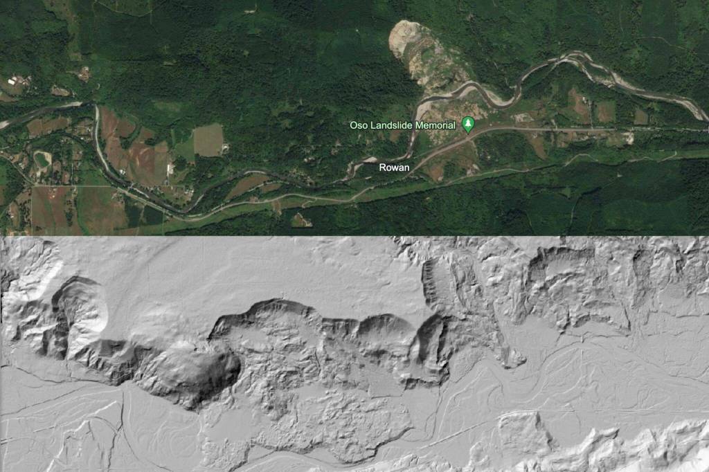
In the early 2000s, Montgomery used lidar data for the first time to look at historic landslides.
“It was like getting a brand new pair of glasses for looking at the land,” he said.
Lidar, an aerial mapping technology, is short for “light detection and ranging” — a technique first marketed in the 1960s that didn’t see widespread use until decades later.
Typically a contracted pilot in an airplane, helicopter or drone flies over a hillside, using a sensor to transmit light pulses to the landscape below and back.
Before lidar, geologists used topographic maps or aerial photographs to identify landslides. But those images had low resolution. And in Western Washington, dense canopies of Douglas fir, Western hemlock and lush vegetation can cloud the view of the land.
Lidar images have high resolution and capture the “bare earth surface,” state geologist Casey Hanell said.
Since the Oso landslide, the state government has invested about $7.1 million in collecting lidar data. The federal government has invested about $5.2 million in the technology for the state.
State geologists take a county-by-county approach to mapping landslides.
“We have prioritized our landslide inventory efforts on starting with the highest-populated areas in landslide prone areas,” Hanell said.
That way, regions with the most risk are mapped first.
As of this year, state geologists have mapped King, Pierce, Snohomish and Whatcom counties, as well as a portion of the Columbia Gorge. Geologists are currently mapping slides zones in Thurston and Chelan counties.
With current funding, Hanell said the Washington Geological Survey plans to complete a statewide landslide hazards assessment by 2040.
‘A long way to go’
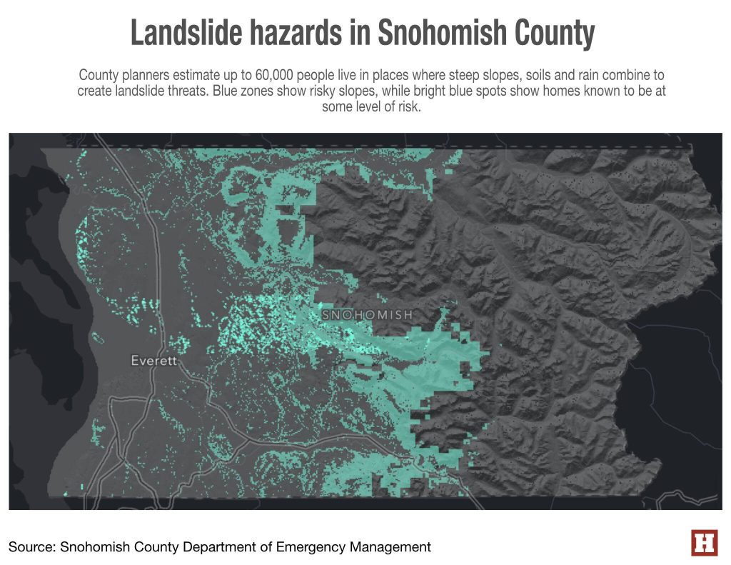
Geologists have identified at least 6,171 landslides in Snohomish County, according to a 2022 report by the Washington Geological Survey. About 458 of them were estimated to have occurred or reactivated in the past 150 years.
The county is home to about 18% of the historical landslides geologists have mapped in the state so far.
At least twice during each mapping process, the state’s landslide hazards team meets with county officials, local experts and emergency managers.
State geologists then share a map of all the landslide hazards in the county, along with a written report, to county leaders. Washington Geological Survey staff try to notify the public through social media once they release a new landslide hazard report, Hanell said.
The state geological survey also helped craft “A Homeowner’s Guide to Landslides.” The pamphlet shows illustrations on what can trigger a landslide, signs of slope instability and tips to reduce risks.
“We look at the forecast,” Hanell said. “When it’s looking like it’s going to rain a lot, and it’s already been wet for a while, we try through the DNR social media to get the homeowner’s guide to landslides out.”
The threshold for risk has changed since the Oso landslide, Hanell said. Too often with natural hazards, it takes a tragedy before risk mitigation and preparation becomes a priority for state and federal officials, he said.
Prior to 2014, the Washington Geological Survey employed one person who devoted half of their time to analyzing landslide hazards. As of this year, the program has five full-time geologists.
This shows promise, Hanell said. But there needs to be more communication among geologists, planners, emergency managers and the public, regarding landslide risks.
He said, “We still have a long way to go.”
What’s the landslide risk where you live?
The Snohomish County Hazard Viewer has a “Mass earth movement” tab, where residents can see if they live in a landslide hazard area.
Visit bit.ly/SnoCoHazard.
Then, in the top left corner of the map, see the search bar to type in an address.
Ta’Leah Van Sistine: 425-339-3460; taleah.vansistine@heraldnet.com; Twitter: @TaLeahRoseV.