A yellow haze settles over the fiery Pacific Northwest
Published 4:30 pm Saturday, September 12, 2020

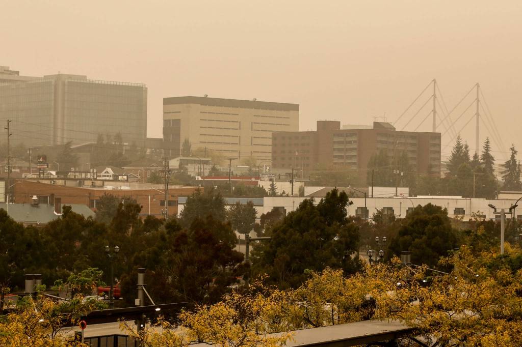


EVERETT — The forecast called for sunny skies on Saturday, but as in much of the Pacific Northwest, the sun never truly came out in Snohomish County.
Instead, residents were greeted in the morning by a yellow-tinted haze, like something out of a science fiction movie. Air quality remained unhealthy for everyone in the region as a massive plume from West Coast wildfires continued to make its way through the state. The Puget Sound Clean Air Agency recommended that people stay inside, with doors and windows closed.
“There are no pockets of clean air to retreat to this weekend,” atmospheric scientist Ranil Dhammapala wrote on the Washington Department of Ecology blog for smoke conditions. “Your favorite campground or hiking trail isn’t going to be magically shielded from smoke, no matter what the elevation.”
A satellite image showed smoke blanketing nearly the entirety of Washington and Oregon. The smoke was expected to linger through the weekend, but some relief could come as soon as Monday in the form of rain showers, according to the National Weather Service’s Seattle office.
Locally, the Downey Creek Fire, 17 miles from Darrington, more than doubled in size, from 1,000 acres on Friday to nearly 2,500 acres on Saturday, and was approaching Suiattle River Road, also known as Forest Service Road 26. Crews were focused on clearing the road of trees, ensuring that the few remaining backcountry hikers could make it back to their cars safely and monitoring the fire.
To give you a visual of just how much smoke has settled in Everett: the photo on the left is from Wednesday and the photo on the right is from this morning. Please stay inside! pic.twitter.com/aDm3SFemE7
— Olivia Vanni (@ogvanniphoto) September 12, 2020
Lightning likely started the Downey Creek Fire on Aug. 16 in the Glacier Peak Wilderness, but it wasn’t until this past week that it exploded in size. Several trails and campgrounds have been closed as a result. U.S. Forest Service spokesperson Jim Chu said resources were already tied up responding to much more dangerous blazes throughout the west, so the agency is in a wait-and-see mode.
“This fire is probably not the highest priority, so it would be very difficult to get resources out here now,” he said.
Chu was optimistic the fire’s growth will slow given the weather forecast, and it’s was far enough away from population centers that it won’t pose a threat to people or properties. However, even just monitoring the fire has proven challenging given smoky conditions. Aerial recon flights to assess the size and what it’s doing have either been ineffective or canceled. Low visibility also has made it difficult to see where hikers might be.
Meanwhile, seven fire departments responded Saturday morning to a property on Woods Creek Road, near Lake Cochran northeast of Monroe, after a house went up in flames. There were no injuries, but the house was destroyed.
Fire crews initially had trouble getting to the home, which was in a heavily wooded area on a narrow road. At one point, they called out a helicopter to help assess the fire from above, but the pilot couldn’t make it due to the regional smoke. A drone was used, instead.
Firefighters lay hundreds of feet of hose through the woods to extinguish the flames, preventing the fire from spreading to nearby trees and brush and avoiding what could have been a much worse situation, according to a news release from Fire District 7.
Besides Fire District 7, agencies responding were the Lake Roesiger Fire Department, Fire District 22, Fire District 5, Fire District 26, the Granite Falls Fire Department, Fire District 4 and the state Department of Natural Resources.
Zachariah Bryan: 425-339-3431; zbryan@heraldnet.com. Twitter: @zachariahtb.