Chime in on narrowed Everett light rail route, station options
Published 1:30 am Friday, February 10, 2023

EVERETT — Closer to Boeing or Paine Field? Disrupting businesses, residents, streams, wetlands? East or west of I-5 at 164th Street SW?
Those are some of the decisions that remain for Sound Transit Everett light rail routes and stations, which people can comment on with their preferences and thoughts through early March.
An online comment period is open through March 10 at https://everettlink.participate.online/. For those who prefer getting information in person, there’s a meeting 5:30 to 7:30 p.m. next Wednesday, Feb. 15 at Cascade High School, 801 E Casino Road, Everett.
Another online meeting is set for 11:30 a.m. to 1:30 p.m. Wednesday, March 1.
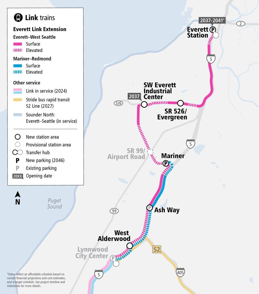
Sound Transit, which runs buses and trains in King, Pierce and Snohomish counties, is gathering input as it develops plans to build 16 miles, six stations (and possibly a seventh if money is available) and a campus for light rail cars and employees in southwest Everett.
Voters in the service district approved the general path and additional taxing on the ballot measure called ST3 in 2016.
Now staff and two groups are reviewing the options of where to build track and construct stations from the Lynnwood Transit Center toward downtown Everett.
One of the two groups helping shape those decisions is comprised of people who live in the area. The other is city and county elected officials.
In September, the elected leadership group spiked further study into diverting the light rail away from the Boeing and Paine Field area in southwest Everett.
By 2026, the Sound Transit board is expected to make final decisions on the routes and stations, which could reach Everett by 2037.
Each Everett Link station has at least two options for location, which affects its route alignment.
Staff reviewed the advantages and disadvantages such as proximity to affordable housing, bus service, destinations and historically underserved communities, potential development and job growth, as well as ease of biking and walking access.
Those evaluations are presented in the online survey, where participants can select and comment on their preferences.
West Alderwood
Lynnwood city leaders years ago identified a station along 33rd Avenue W west of the mall as their preference. It would best connect with Community Transit’s Swift Orange bus rapid transit line under development for service in 2024, when light rail reaches the Lynnwood and Mountlake Terrace transit centers.
But another option could put the light rail station north of the Alderwood mall near 184th Street SW.
A third alternative studied south of the mall was found to have no advantages over the other two.
All three options for the station closest to the Alderwood mall would be elevated. There’s no new parking planned around the station as part of the project.
Ash Way
Snohomish County’s vision for this site differs from the representative alignment. The County Council voted for a location east of I-5 and north of 164th Street SW as its preference. Sound Transit initially envisioned it near the Ash Way Park and Ride.
There are bus connection, development capacity and displacement concerns for both.
A station east of I-5 would be below street level, and one west of the freeway would be elevated.
Putting the station east of I-5 leverages development potential in that area.
The county is considering building a new crossing over I-5 to bolster connection with the Ash Way Park and Ride.
Mariner
All three route and station options would be elevated as the track winds toward 128th Street SW west of I-5. The stations would be larger than others on the Everett expansion because it will be a major transit hub and light rail transfer point for service to Seattle and Redmond. Another 550 parking spaces are planned as well.
Option A would be north of 128th Street and between 6th and 8th Avenues W.
Option B would be south of 128th Street near 8th Avenue W.
Option D is closest to the existing Mariner Park and Ride and the county’s preferred location.
Airport Road and Highway 99 (provisional)
Option A would be north of the intersection and option B west. Either would have an elevated station and tracks.
Southwest Industrial Center
Each of the options would be designed with room for shuttle service and an elevated station and tracks.
Everett Mayor Cassie Franklin has been adamant that option A best serves the city. The northern-most site would be closest to Boeing and residences along Casino Road just south of Highway 526. A bridge over Highway 526 to Boeing is possible.
Option B would be along the west side of Airport Road between Casino and Kasch Park roads.
Option C would be on the east side of Airport Road near 94th Street SW, about three-quarters of a mile from the Paine Field passenger terminal. For comparison, the walk from the Sea-Tac light rail station to the airport terminal is about 950 feet.
Evergreen Way and Highway 526
The station with the most options remaining is a major nexus of the highway, Casino Road and Evergreen Way.
Option A is the only site north of Highway 526 and would have a station below street level west of Evergreen Way.
Option B would be an elevated station northwest of Casino and Evergreen.
Option C would be an elevated station northeast of the intersection of Casino and Evergreen.
Option D would be an elevated station southwest of Casino and Evergreen.
Option E would be an elevated station southeast of Casino and Evergreen.
Everett Station
The northern terminus of the light rail expansion could land at the existing Everett Station transit hub or get closer to downtown. Each option would have an elevated route and station. About 1,000 new parking spaces are planned in this project.
Option A is closest to existing services at Everett Station, including Swift Blue line bus rapid transit.
Option C would be along McDougall Avenue south of Pacific Avenue, a couple blocks west of Everett Station and east of downtown.
Option D would be along Broadway north of Pacific.
Everett’s subarea plan envisioned a station between McDougall and Broadway with new separate pedestrian connections to mitigate the slope of between downtown and Everett Station.
OMF North
The operations and maintenance facility (OMF) needs 60 to 70 acres to store light rail cars and for about 450 employees. All four sites are in southwest Everett.
Everett’s mayor has opposed options B-1 and B-2 north of Highway 526 over concerns it would displace specialized industrial businesses.
Option E would be east of Airport Road and north of Holly Drive.
Option F would be southwest of the intersection of Airport Road and Highway 99, roughly west of the highway and bound by Alexander Road and Gibson Road.
Ben Watanabe: 425-339-3037; bwatanabe@heraldnet.com; Twitter: @benwatanabe.