Whidbey wandering on the rugged Pacific Northwest Trail
Published 1:30 am Sunday, January 24, 2021
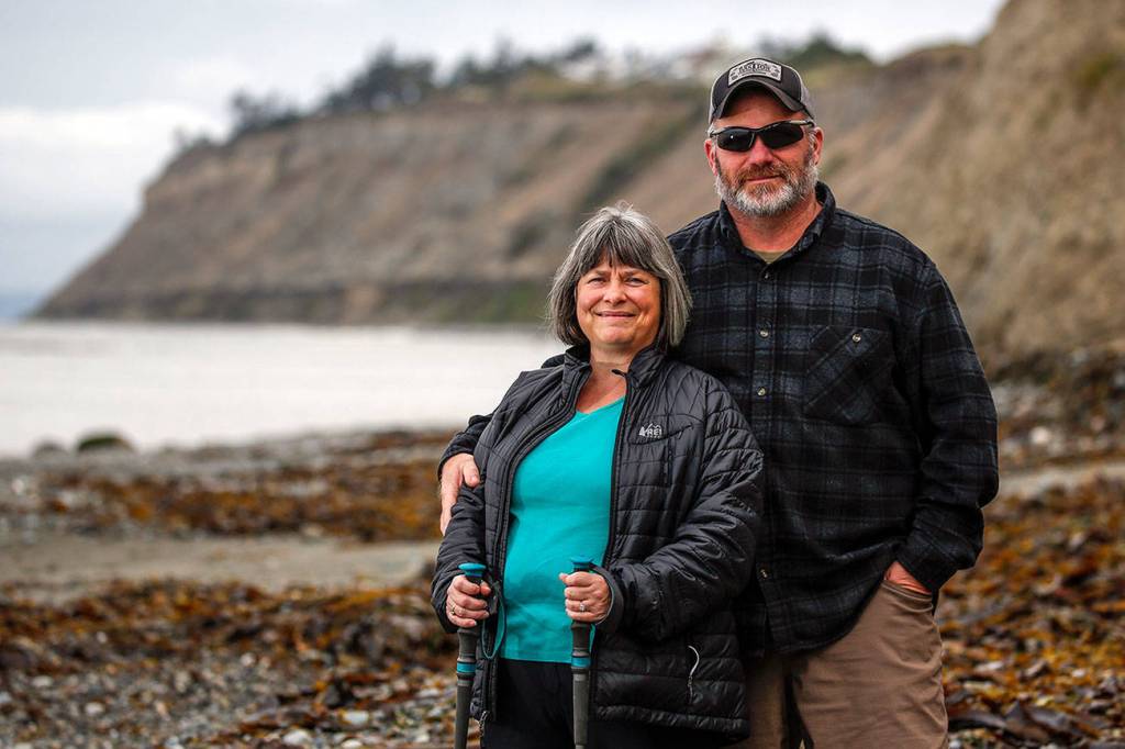


To get to John and Rebecca Roberts’ house, walk west for 993 miles, then take a left on Libbey Road.
Most of their houseguests are four-fifths finished with a 1,200-mile journey, and ravenous for anything except peanut butter. The Roberts began hosting Pacific Northwest Trail thru-hikers at their home just north of Fort Ebey on Whidbey Island in 2012.
At first, it was one visitor, then one of his friends he made along the way. Then, a few more.
As the trail’s reputation has spread among distance hikers, John Roberts stocks up on about 100 pounds of hamburger each summer in preparation for 12, 40 or even 80 guests, depending on the year, who are grateful for clean sheets, a hot shower and hearty plates of taco salad. The couple turns the lower half of their 1½-story house into a hiker haven.
“You see all kinds,” said Rebecca Roberts, 56, a middle school Spanish teacher. “It’s a tougher trail than most. We do get a lot of experienced hikers, and then you get a few hikers where it’s the first thru-hike they’ve ever done.”
Trail angels are common on the well-trafficked Pacific Crest Trail, but relatively rare on the newer, more rugged PNT.
The trail threads seven mountain ranges — from the Rockies to the Olympics — hugging the Canadian border from the Continental Divide in Montana to Cape Alava, the westernmost tip of the contiguous United States.
Young conservationist Ron Strickland dreamed up a PNT route in the 1970s, when the official PCT was still new. A small group of Oregonians thru-hiked it for the first time in 1977. The trail evolved piece by piece, and it was officially recognized by Congress in 2009.
Over the past decade, the annual number of known finishers tells a story of its own: 1, 0, 2, 1, 2, 5, 17, 8, 34, 30, 29. It’s almost definitely an undercount, but you get the idea.
At a pace of 20 miles per day, a typical thru-hike consumes two summer months and two pairs of decent trail runners. The weather window is as brief as summer in alpine along the 49th Parallel. Much of the trail is unmarked. Many hikers rely on imperfect GPS to find the way. There’s ample bush-whacking, talus-scrambling and road-walking.
Eric Wollborg, a spokesman for the Pacific Northwest Trail Association, has hiked both the PCT and PNT. He and his wife completed the latter in 2016.
“It had so many opportunities to have solitude, see wildlife and solve problems on your own,” Wollborg said. “The route is incredibly well-signed along the PCT, for example, and the PNT just felt like a real adventure. On the entire trip, I think we only saw one other thru-hiker.”
Here’s the secret, though. You don’t have to do the PNT all at once, if you don’t have the time, patience or knee cartilage. In the lowlands of Western Washington, for example, you can explore more than 100 miles of the trail even in winter, when mountains are snowed over and hikers need somewhere to go.
Our slice of the trail
The PNT dips out of the North Cascades south of Mount Baker; it follows Skagit County logging roads into the Chuckanuts, where westbound thru-hikers get their first smell of salty sea air; it turns into waterfront paths and inland community forest in Anacortes; then it crosses the Deception Pass Bridge to 33 miles of Whidbey Island beaches, bluffs and bike paths, en route to a ferry bound for Port Townsend, the Olympics and the finish line.
The PNT truly is a patchwork in this region, as I learned well while walking the Whidbey Island stretch. It rambles past two historic military forts, one very active (and very loud!!!) naval air station, five county parks and five state parks. Part of it is 15 miles of regrettable, rural asphalt with scarce water, views or persuasive reasons to visit again. Paved road is a necessary evil on a thru-hike of the PNT, a big trail made up of many shorter trails stitched together. But it’s wasted time on a two-day trip, unless you’re a purist, a masochist or both.
“You’d have to be pretty excited about the trail, pretty die-hard, to want to walk through there,” Wollborg said of the Whidbey Island road walk.
Of course, this little piece of advice came after I’d hiked it over a weekend. Allow me to give you a flavor anyway.
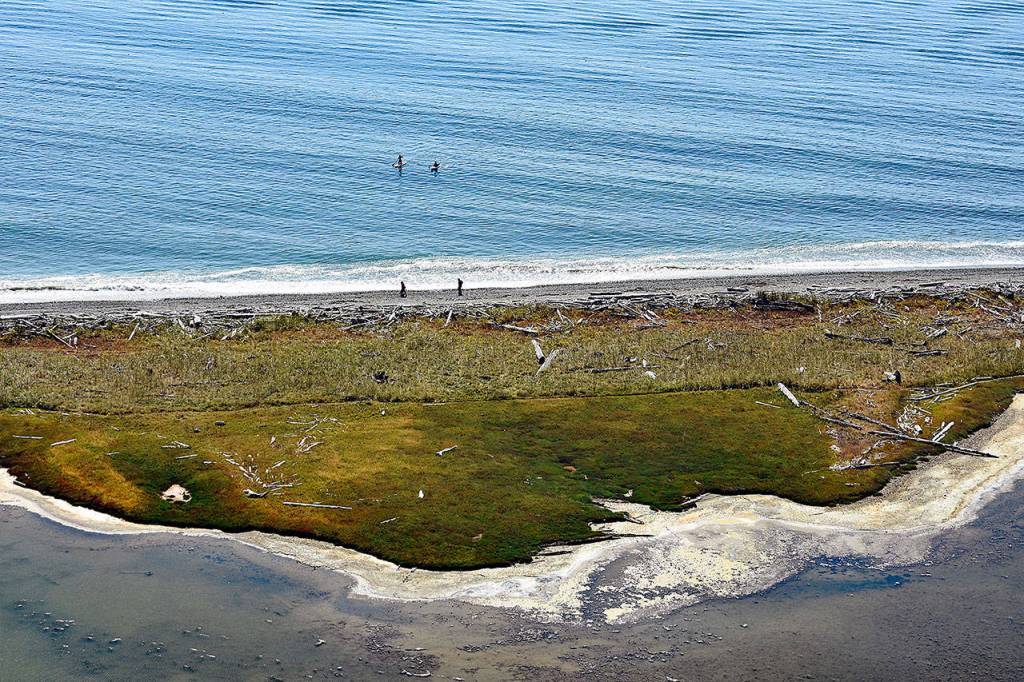
My hiking partner, Kate Fujimoto, and I parked one car just north of Deception Pass and another car south of Coupeville, beside the ferry terminal. We went eastbound — reverse of normal, because why not? — into Fort Casey State Park. You could walk inland trails between World War I-era bunkers and the Admiralty Head Lighthouse, depending on your mood. We had blue skies and hours of low tide ahead, so we stayed along the rock-and-sand beach for miles.
Slick brown kelp beds bobbed in sparkling Admiralty Inlet. A heron perched on floating driftwood. Sanderlings and plovers played chicken with the soft-crashing waves. Far west above the Quimper Peninsula, the Olympics looked like jagged blue silhouettes painted on a movie set. Behind us, rocks the size of baseballs trickled down a cliff, and I yelled something about how I wouldn’t want to walk under these bluffs in a storm.
National Scenic Trails run across the country like veins on the back of an outstretched hand. Of the 11 scenic trails designated by Congress, the PNT is the only one where you need to study a tide chart.
Its toughest coastal stretch pushes north of the Hoh River on the Olympic Peninsula, with impassible headlands, miles of algae-slick rocks, frequent and relentless rain, tricky tides that force you to triangulate daylight versus your hiking pace versus high tide, and rope ladders up muddy bluffs to muddy trails pocked with mud pits. North Whidbey’s beaches are a light version of this, slow-going in tideland, but sheltered enough for millionaire homes to rim the bluffs above you.
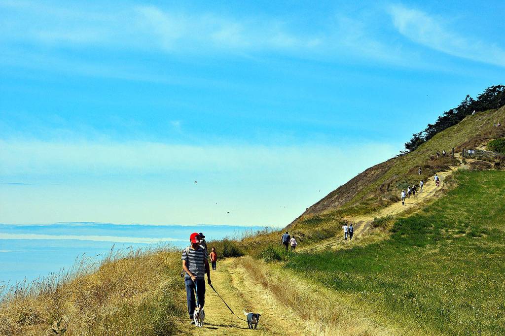
Our brief solitude ended as we turned a corner to find visitors fishing and walking dogs at Ebey’s Landing. The views of the Salish Sea and Vancouver Island grew more dramatic when we climbed cliff-side trails where pioneer Isaac Ebey must have admired many sunsets, until a native raiding party beheaded him at his farm in 1857.
The landing is a popular 5-mile day hike, looping around mirror-like Perego’s Lagoon onto a pleasant beach. But when we switchbacked down we kept going east on the PNT, along the curve of the island, away from crowds.
One popular trail digest is written for hikers going west, and supposedly there’s a low point on the crumbly wall of sand where one can slide from the Cedar Hollow trail to beach.
Looking up that bluff, we shrugged in confusion and kept trudging on rock for another 1.25 miles. We rounded Point Partridge, where we saw about a dozen surfers and signs for Fort Ebey State Park. Hiker camping is available for $12. Given the lack of camps on our map north of here, we pitched our tent and refilled our water bottles from spigots.
We’d gone less than 8 miles.
So we woke before dawn in a light drizzle for a 26-mile day. Official maps tell you to follow the beach north. The digest says you can take the beach or walk the road if the tides are up. Two PNT markers — the only two we saw, until we hit Deception Pass — suggested going inland to Lake Pondilla near Coupeville. The trail is a maze of ideal, practical and alternate routes. Tides were friendly, so we scooted across the sand toward Libbey Beach Park.
Across the island
Rebecca Roberts first learned about the trail from a thru-hiker’s blog on Postholer.com. She emailed “Buck-30,” a Triple Crown hiker who has walked all 7,900 miles of the Pacific Crest, Continental Divide and Appalachian trails.
At the time, he was east of Ross Lake. She offered to let him stay at the house. Her husband John, 53, a contractor, was understandably wary of inviting strangers into his home.
“From my background, I’m skeptical of everybody,” he said.
Then he started to meet all of these hikers, from England, Ireland, France, Germany and Australia, on 90-day visas. One guest was a Yale grad who studied economics, became a pro windsurfer in Hawaii, then caught an incurable bug for hiking. Another got injured in the Cascades, healed up at their home for about two weeks on Whidbey — until “Pounce” realized the window was closing and she had to wait until next year to finish. (She did.)
Sometimes the Roberts will pick up hikers in downpours. Some have declined that offer, wanting to finish unaided. By mile 993, most feel pretty hardy and accustomed to rough going. Some just want to charge a phone and move along.
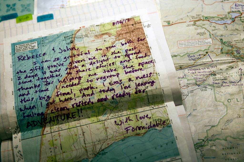
Sojourners passing through the Happy House have created an annotated map of the Olympics, highlighting good camps, bad camps, spots to resupply and more. John and Rebecca worked on search and rescue teams near Yakima. Now they often help hikers to navigate the backcountry permit system of Olympic National Park, where the rangers know of them.
Everyone on the trail has a story to tell. Some are “going through something” in their lives, John Roberts said. The trail and its lifestyle are their way of soul-searching. One of their most bubbly and vivacious visitors, “Bloody Mary,” began distance hiking when her mom died of a brain tumor.
Rebecca Roberts has always hiked, but not too much, until she got a simple piece of trail wisdom from one of her new friends: “You just go ‘til you can’t go, then you stop.”
The couple took a planned break for the 2020 season, but hope to be back this year.
North of Libbey Beach Park, the trail is 5 miles of beach flanked by enormous bluffs, seaweed fields and waterfront neighborhoods. The trail moves inland at a parking lot for West Beach. This could serve as a trailhead for 13 miles of uninterrupted coastal hiking, one way, back to Fort Casey.
The highlight of the road walk was a taco truck, Mi Taco Is Your Taco, serving up meaty burritos worth every cent of $15 to a clientele of Oak Harbor airmen from 8 a.m. to 3 p.m. We passed a public golf course, farms and many other exciting things you could also see by driving this stretch.
The shoulder thins to a few inches along Taylor Road. The PNT seems to fade out miles later on Anglers Haven Drive. Some bushwalking led to a well-established footpath in old growth forest, looping toward Cornet Bay. The Hoypus Point Trail pops out at a marina with views of the famous bridge.
Again, it’s easy to get lost near the Cornet Bay Retreat Center, since the wooded trail is unmarked, just west of the exit for a one-way driveway. It’s prettier on the car-free side of the calm bay, and we chose a three-quarter-mile alternate route of tight switchbacks to the bare summit of Goose Rock.
Signs warned, “Please respect the balds.” So while respecting the balds, we stood on top and looked over what we’d just spent the day slogging through, all the way to Fort Ebey.
Counting a break for lunch, we had hiked 12 hours by the time we reached the car near Rosario Head.
Could I have done that for 60 days or more? Maybe.
Would it have been more meaningful to have crossed three states to get here? Oh, absolutely. But it was worthwhile to feel even some tiny connection to hikers who went before.
Cars rumbled over Deception Pass. About 180 feet below, a pair of kayakers battled currents pushing them backwards. They paddled fiercely, surrendered for a moment, then kept paddling again. We didn’t wait to see if they ever made it.
Hiking Pacific Northwest Trail
PNT.org is chock full of maps, history and advice for hikers. Start there.
Guthook makes a smartphone app that has become a lifeline for many distance hikers. I used it with no major issues. But never depend on an app alone, and always carry a backup paper map that doesn’t require batteries.
The Pacific Northwest Trail Digest 2020 proved extremely handy. It should be paired with a good map, however. If you’re not comfortable in your navigation skills, hike with someone more experienced, or take an outdoors class.
Even on this relatively populated stretch of trail, tides are serious business. You can get stranded, hurt or worse. Do research ahead of time and don’t take dumb risks.
As of 2021, this region is a blind spot in the Green Trails catalog, but there are other good options to fill the gaps.
Washington North Coast Magazine
This article is featured in the fall/winter issue of Washington North Coast Magazine, a supplement of The Daily Herald. Explore Snohomish and Island counties with each quarterly magazine. Each issue is $3.99. Subscribe to receive all four editions for $14 per year. Call 425-339-3200 or go to www.washingtonnorthcoast.com for more information.