Weather updates: Red Cross shelter opens at fairgrounds in Monroe
Published 3:20 pm Monday, December 8, 2025


EVERETT — A second round of a “substantial” atmospheric river was expected to hit Snohomish County on Tuesday night, elevating concerns for rising rivers, potential landslides and flooded roads.
The National Weather Service has issued flood warnings for numerous locations throughout the county, including areas surrounding Arlington, Everett, Snohomish, Monroe, Sultan and Gold Bar.
After a brief lull that saw sunshine in Everett for a few hours Tuesday, the weather service called for the atmospheric river to shift north again.
For real-time updates throughout the weather event, please see heraldnet.com.
Here’s a snapshot of how the storm played out across the county Monday night into Tuesday.
Red Cross Shelter opens at Evergreen State Fairgrounds
The American Red Cross Northwest Region opened an emergency flooding shelter at the Evergreen State Fairgrounds, 4H Building: 14405 179th Ave. SE., Monroe.
Anyone impacted by the flooding can go to the shelter to connect with others, get a warm meal and find support, the organization said in a Facebook post.
Red Cross teams are continuing to monitor flooding activity to provide safe shelter where necessary.
Also at the Evergreen Fairgrounds, emergency stabling is available for livestock at the Equestrian Park.
— Jenna Peterson
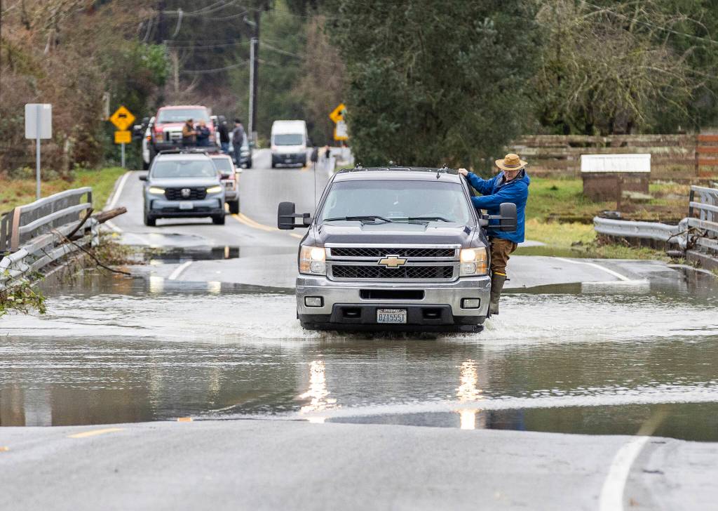
Snohomish River inundates a portion of Old Snohomish Monroe Road
Flood water from the Snohomish River crossed over Old Snohomish Monroe Road late Tuesday morning and continued to rise into the early afternoon.
Residents Bella Reid and her fiancé, Hector Rodrigues, live two houses up from where the water swallowed the road, and have been in their house for a decade. As the water crept up the street, the pair taped tarps to their garage door, ripping open bags of inflatable sandbags and hoping for the best.
“What else can I do?” Reid asked herself, looking at the setup from underneath her black baseball cap. “I can’t stop Mother Nature.”
The couple planned to stay in their house on Tuesday night with their three cats and two dogs, but said if the driveway starts looking like they won’t be able to safely leave, they’ll take their pets and themselves to higher ground.
— Eliza Aronson
City of Snohomish issues emergency proclamation
Snohomish Mayor Linda Redmon issued an emergency proclamation effective at noon on Tuesday as the Snohomish River reached 27.08 feet, meeting Flood Phase 3. The proclamation supports flood response, resource coordination and recovery, the city wrote in a Facebook post.
A self-serve sandbag station is located at the Carnegie Building, 105 Cedar Ave. The city asks residents to bring gloves and a shovel to self-fill sandbags.
The city has closed Pilchuck Park, Cady Landing and Kla Ha Ya Park. The Carnegie parking lot will be closed to public parking through Friday to make room for flood response operations. Lincoln Avenue is closed at First Street due to high water and safety concerns.
— Jenna Peterson
Floods cause road closures throughout the county
Several roads throughout Snohomish County closed due to flooding. For updates, check the county’s Public Safety Hub at https://bit.ly/snocoflooding.
As of Tuesday afternoon, the following roads were closed:
• Pioneer Highway in Stanwood between 212th Street NE and 236th Street NW due to water over the roadway.
• Pioneer Highway in Stanwood between Marine Drive and 70th Ave. NW.
• Ben Howard Road in Monroe between the 23900 block and 260th Ave. SE due to water over the roadway.
• Crescent Lake Road in Monroe from High Bridge Road to 203rd Street SE due to water over the roadway.
• 399th Ave. SE in Gold Bar from the 40400 block to the end of the street due to water over the roadway.
• 311th Ave. SE in Sultan from N Skyview Drive to Ben Howard Road due to water over the roadway.
• Reiter Road, Ave. A, in Index between 109th and 125th due to trees down.
— Eliza Aronson
Flooding begins in Monroe and Snohomish with more expected
At 9:15 a.m., the Snohomish River near Monroe was measured at 16.2 feet — just over a foot above flood stage. The river will peak at 16.2 feet on Tuesday afternoon before falling to 14.1 feet on Tuesday evening. Late Tuesday night, the National Weather Service predicts the river will rise, peaking at 23.6 feet Thursday afternoon before subsiding Friday afternoon.
These levels compare to a flood event on Nov. 11, 2006.
In Snohomish, the river gauge measured 26.9 feet, with the flood mark at 25 feet. The National Weather Service forecasts the river peaking at 27.9 feet late Tuesday afternoon, potentially rising to 33.3 feet early Friday morning.
On Dec. 12, 1975, the river hit 33.2 feet.
— Eliza Aronson
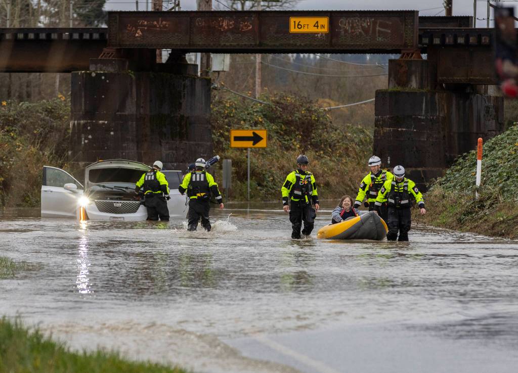
Two rescued from car on Old Snohomish Monroe Road
Snohomish Regional Fire & Rescue and Snohomish County Fire District 4 responded with water rescue units to a 911 call of two people stuck in a vehicle on Old Snohomish Monroe Road around 8 a.m. on Tuesday. Both people were removed from the vehicle via inflatable kayaks and were being checked for any injuries, but both were conscious and walking, one with assistance.
Fire District 4 Battalion Chief Shawn Osborne said he’s connected with Snohomish County officials to close the road on both the north and south sides of the crossing as water from the Snohomish River continued to rise, rushing onto a field.
“Do not wade or drive through any standing water on a roadway,” Osborne said. “There’s no telling how deep it is.”
— Eliza Aronson
Minor flooding in Arlington along Stillaguamish River
Minor flooding is occurring and is along the Stillaguamish in Arlington until Friday morning, according to the National Weather Service.
At 3:35 a.m., the river gauge measured 16.8 feet, surpassing the flood stage mark at 14 feet. The river will continue to rise Tuesday morning to 17 feet before falling below stage level to 9.7 feet this evening.
Tuesday afternoon, the river is expected to rise again, reaching 17.4 feet early Thursday morning.
These peak flows compare to a flood event on Dec. 15, 1999.
— Eliza Aronson
Near record flooding predicted for Snohomish River near Snohomish
The National Weather Service is predicting severe, near-record flooding for the Snohomish River near Snohomish and Monroe.
Near Snohomish at 2:00 a.m., the river gauge measured 21.3 feet, with the flood stage marked at 25 feet. The National Weather Service predicts the river will rise early this morning above flood stage, reaching 31.9 feet late this afternoon. It is predicted to rise to 34 feet early Thursday morning, reaching 35.3 feet late Thursday evening.
“At 33.0 feet, the Snohomish River will cause severe near record flooding. Flood waters will likely overtop levees…with major levee damage possible,” the weather service stated. “Flood waters will inundate much of the river valley…including SR2 west of Monroe…SR9 and the Lowell-Snohomish River Rd.”
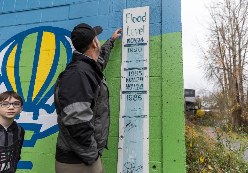
This peak flow compares to when the river hit 33.5 feet on Nov. 25, 1990.
Near Monroe at 3:12 a.m., the river gauge was at 13 feet, with the flood stage mark at 15 feet. The National Weather Service predicts the river will rise to flood stage this morning, reaching 18.2 feet this afternoon before dropping to 14.9 feet late this evening. The river is predicted to reach 25 feet by late Thursday evening.
This peak flow compares to the flooding event on Jan. 8, 2009, when the river hit 24.1 feet.
— Eliza Aronson
1:08 a.m.
Major flooding in Sultan along Skykomish River
Major flooding is occurring and is predicted along the Skykomish River near Index, Gold Bar and Sultan until further notice, according to the National Weather Service.
At 1:08 a.m., the river gauge measured 20.1 feet, surpassing the flood stage mark at 15 feet.
“At 19.0 feet, the Skykomish River will cause major flooding from near Index downstream through Sultan to the Snoqualmie,” the weather service statement issued. “Flood waters will inundate portions of downtown Sultan…most roads and the Tualco Valley area near Monroe.”
The last time the river reached 19.9 feet was Nov. 23, 1986.
— Eliza Aronson
Flood warning for Stillaguamish River at Arlington
The National Weather Service issued a flood warning for the Stillaguamish River near Arlington on Monday evening, for moderate flooding until late Thursday evening.
At 7:55 p.m., the river gauge measured 11.8 feet, with the flood stage marked at 14 feet. The National Weather Service predicts the river will rise later this evening, peaking at 17.8 feet early tomorrow morning.
“At 17 feet, the Stillaguamish River will cause flooding mainly in the Silvana area, along Norman Road and in Florence. A stage of 17 feet on the Stillaguamish River corresponds roughly to Phase 3 in the Snohomish County Flood program,” the issue stated.
The river is expected to fall below flood stage Tuesday night, before rising again on Wednesday and peaking at 15 feet on Thursday.
The last time the river hit 17.8 feet was Nov. 19, 2003.
— Eliza Aronson
Marysville’s after-hours emergency line
Via the city of Marysville Facebook page, residents were directed to call the city’s after-hours emergency line at 360-363-8350 if there is water over the roadway or other hazardous conditions after 4 p.m.
— Taylor Scott Richmond
Cold weather shelters open
Snohomish County’s seven cold weather shelters are expected to be open Tuesday night due to the potential for flooding and extreme weather, even though temperatures aren’t expected to reach 34 degrees Fahrenheit. Real-time information about cold weather shelters is available on the county website. Intake times vary from 4-8 p.m. at shelters in Everett, Marysville, Lynnwood, Snohomish and Monroe.
— Jenna Peterson
Stanwood deploys floodwall
In preparation for possible flooding, the city of Stanwood will deploy its floodwall, closing Marine Drive (84th Ave NW), just beneath the SR 532 Overpass near 267th St NW on Monday afternoon. The city expects to keep the wall closed for 1-2 days. Follow North County Regional Fire Authority on Facebook for updates.
— Eliza Aronson
Self-fill sandbags in Snohomish
The city of Snohomish has opened a self-fill sandbag station at 1529 First Street, west of Avenue D on the south side of the road.
In addition, the Volunteers of American Western Washington will open the Snohomish Cold Weather Shelter tonight. Unsheltered community members can find more information about the shelter at https://bit.ly/snococold or by calling 2-1-1.
— Eliza Aronson
Snohomish County activates Emergency Operations Center
Snohomish County activated its Emergency Operations Center on Tuesday morning to coordinate community responses, said Snohomish County Department of Emergency Management spokesperson Scott North in a Monday email.
“Look for downed powerlines and other debris. Never attempt to drive through water across roadways. As little as a foot can float a car, and there’s no way to gauge the depth from the driver’s seat,” he said.
The county will share information on social media during the event but strongly encourages people to monitor the flood page on the Snohomish County Public Safety Hub for updates and quick access to key resources, including real-time river gauges, interactive maps and alerts. Find updates at: https://bit.ly/snocoflooding
People can also sign up for alerts at: SnoCoAlerts: https://Snocoalerts.snoco.org.
River gauge alerts: https://snohomish.onerain.com, click “Subscribe to Flood Notifications,” select which river basin you are interested in then select the gauge. This lets you monitor river levels at specific locations in real time.
— Eliza Aronson