After Oso disaster, landslide prediction remains vexing, necessary
Published 1:30 am Sunday, January 2, 2022
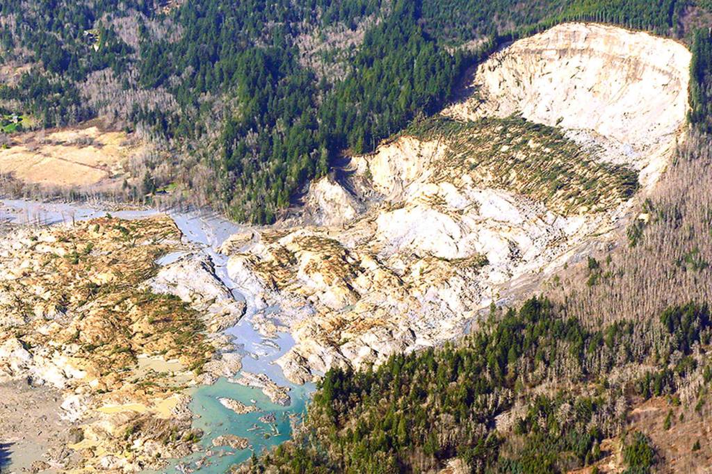
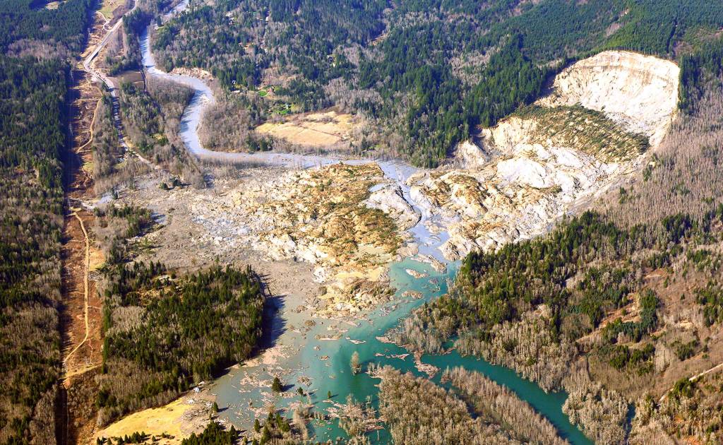

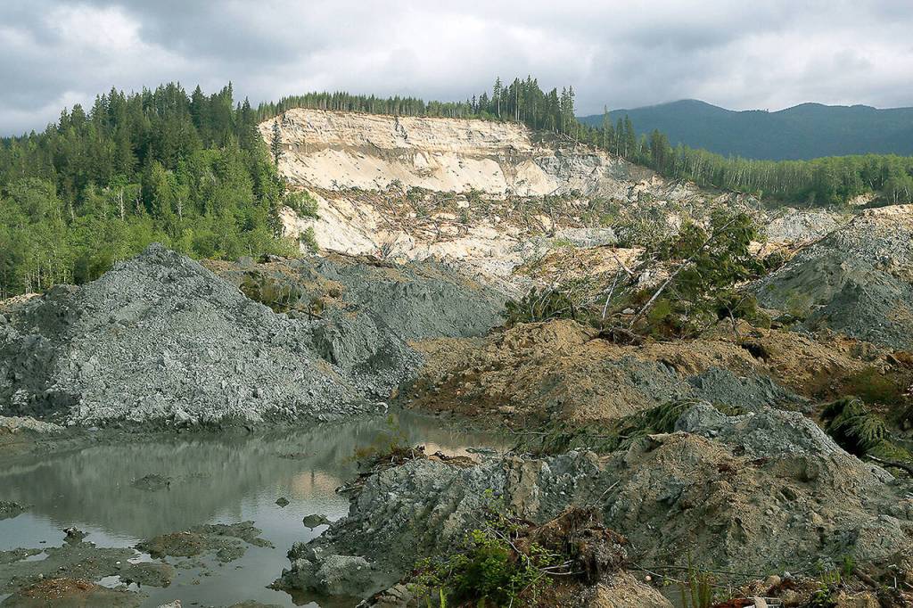


In a single minute, the deadliest landslide in the nation’s history killed 43 people in Snohomish County.
The 2014 disaster near Oso inspired action by Congress and the state Legislature. It led to changes in the county hazard map, tougher logging regulations and improved disaster response.
But landslide prediction remains vexing. And climate change is magnifying the need for both research and public awareness of slide danger.
Scientists have not established a cause-and-effect between changing climate and landslides, in large part because there is little historic record of slides. But the most frequent cause of landslides worldwide is rainfall, and there is a strong link between a warming planet and episodes of intense rain.
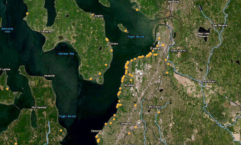
NASA is studying that connection. It has created a worldwide database and map and invited the public to report slides. Since 2015, the Washington Geological Survey has maintained a Google map of recently reported landslides for the state. And staffers scour news and government agency reports, even social media, for information.
Northwest summers are getting drier, but we are getting no less annual moisture — it’s just being compressed into the colder months. This November, massive storms in British Columbia caused not only flooding, but landslides that killed people and isolated cities. Record-setting rain preceded the Oso landslide, said Rex Baum, a geologist with the U.S. Geological Survey. Rainfall totals that March, as measured 12 miles away at the Darrington Ranger Station, exceeded most historical rainfall totals since 1927 and totals for any previous four years. But no one predicted a slide that devoured a subdivision, buried Highway 530 and raised fears that the Stillaguamish River would be dammed by rock.
“We can’t say, ‘Oh, yeah, everybody should have known,’” said Baum, chief of the USGS Landslide Initiation Process and Probability Project.
It’s only in the past few years that the National Weather Service has issued special weather statements alerting the public to landslide danger. Those are “pretty broad-brush for most of Western Washington, not like the river-specific flood watches,” said Seattle meteorologist Dustin Guy. The basis of the alerts is a USGS precipitation threshold tool, created around 2006 and watched keenly by emergency managers. It factors not just rainfall over the past three days, but also how much fell over the past 15. A five-inch rainfall in October isn’t as scary as one that arrives in December or January when the soil is already wet, Baum said.
The threshold tool relies on rainfall gauges at four airports: Paine, Boeing, SeaTac and Tacoma Narrows. Flat places, all. Researchers regularly keep an eye on just one steep and slide-prone place in Northwest Washington. In 2015, with money from Sound Transit, USGS installed groundwater monitors on a Mukilteo bluff that regularly sloughs onto railroad tracks. Combined with two nearby rain gauges, they provide an early-warning system that has reduced the number of times Sounder commuters are endangered by slides or inconvenienced by unnecessary cancellations.
Northwest Washington is custom-made for landslides. Beneath our feet are glacial deposits that were densely compacted by layers of ice but never turned to stone. Waves have battered the deposits that sit along the edges of past and present water bodies, like Puget Sound, eroding them into steep slopes. Rain and snowmelt percolate down, as deeper groundwater seeps sideways. Then, when the weakened glacial deposit can’t take anymore, everything collapses.
Landslides kill an estimated 25 to 50 people in the United States every year. Congress recognized the threat in 2020 when it passed the National Landslide Preparedness Act to shore up USGS staff and provide grants for research and mapping. It called for funding of $37 million for 2021, but lawmakers only appropriated $8 million. Washington Rep. Suzan DelBene, the 1st District Democrat who sponsored the bill, is pressing for more funding.
Though the $8 million doubled the budget of the Denver-based landslide hazards program, Baum said, “It doesn’t pay for enough staff to do landscape studies over the entire country or provide grants.” For now, his agency is working with others to develop a strategy for spending additional money when it is available.
Seeing through the trees
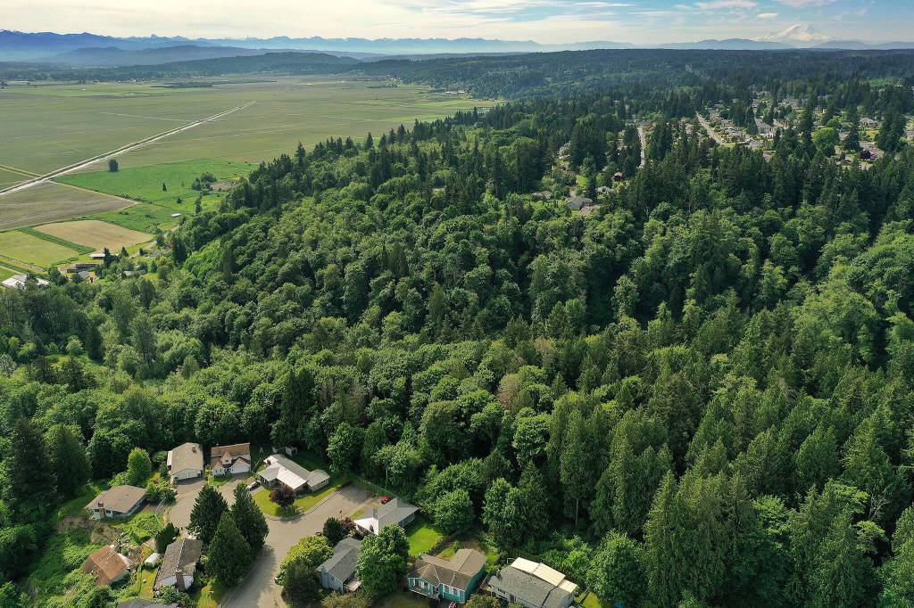
Unlike other states, Washington needn’t rely only on federal money for landslide research. In 2015, the Legislature approved creation of a five-person Landslide Hazard Program within the Washington Geological Survey, part of the Department of Natural Resources. It also funded two positions focused on lidar, an aerial mapping technology that is the best way to document historic landslides, like those above Highway 530 that preceded the Oso disaster.
Lidar, short for light detection and ranging, is used in everything from the latest mobile phone cameras to a helicopter that flies over Mars. When a three-foot-wide lidar camera is pointed down from a small airplane, it captures images at multiple levels. By stripping away the first things the lidar hits, geologists are left with a detailed picture of the ground, said Landslide Hazard Program Manager Kate Mickelson.
“Lidar is what I need to do my job,” Mickelson said. “Abby and Guy can strip aside trees and houses so I can see bare earth surfaces.”
That’s Abby Gleason, the state’s lidar manager, who began her career with the National Geospatial Intelligence Agency; and Guy McWethy, who checks the data gathered by the contracted lidar pilots against other site information that’s available. The result is information for DNR that’s available on the state’s lidar portal for anyone else who finds it useful, such as wildland firefighters or landowners.
The best time of year for lidar flights is late fall through early spring, when leaves are off the trees. They don’t fly when it’s raining, and lidar won’t penetrate snow. Ideally, surveyors are on the ground at the same time as the flights, said Gleason. The pilots fly about 6,000 feet, in a pattern they call “mowing the lawn.”
As lidar data becomes available, the Landslide Hazard Program uses it to create county maps that show landslides. A first-of-its-kind map of western Snohomish County will be available by June 2022, Mickelson said.
Maps using up-to-date lidar are already available for three parts of Snohomish County. Those are a snippet of the Bothell area captured as part of King County’s mapping, swaths of public land in the east, and the Oso disaster area. Three lidar flights were done after the 2014 landslide. The Legislature rejected three requests to fund a more detailed analysis along that Highway 530 corridor, Mickelson said.
Right now, lidar flights are focused east of the Cascades. It won’t be long before the entire state is captured. But the work will be ongoing, Gleason noted, because the data should be refreshed every 5 to 10 years.
“You want to capture how the landscape is changing,” Gleason said. “There will be more erosion on bluffs, changes in the streams.”
The lidar program’s biannual budget is $1.5 million. To pay for the ongoing work, DNR will ask the Legislature to add $3.48 million for fiscal 2022, then provide $7.75 million to cover 2023-25. That would pay for two new positions and improved technology. The program’s Google map of recent landslides, a Homeowner’s Guide to Landslides and other information can be found online by searching for “Washington landslides.”
One of Mickelson’s top concerns is that local governments, especially those with populations expanding into hills, aren’t coming to her program for the latest information.
“That doesn’t make sense to me. This is an important public safety issue,” she said. “Cities and counties need to integrate this data into their planning.”
Slashes of orange and red
Mickelson often hears from people worried about a slide on their property. She lacks the staff to help and advises they do a web search to find a geotechnical expert in their county. Neither her office, nor Snohomish County, maintain a list of experts. If danger is imminent, Mickelson added, people should leave the property and call emergency services.
“It’s not the end of the world if you live on a landslide. A lot of these landslides haven’t moved for hundreds of thousands of years,” Mickelson said. She added that property owners can reduce risk by leaving deep-rooted plants in place and not overwatering.
State code, plus city and county permitting rules, require builders to have their sites evaluated for potential instability. On rare occasions, someone is allowed to build on the site of an earlier landslide.
After the Oso slide, Snohomish County significantly expanded the definition of “landslide hazard zone.” Its geologic hazards map, dated 2016, is a starting point for developers, concerned property owners and the simply slide-curious. It shows known landslide areas in red, ranging from ribbons along the coast to big blotches in the mountains. Cross-hatched landslide hazard areas show up mostly near steep eastern slopes. Lightning-like slashes of orange, “areas susceptible to basal undercutting,” outline the many creeks that define the region’s landscape.
An Everett slide-prone zone that’s getting attention is the 92½-acre Wood Creek property. It falls at the intersection of forest preservation, public finances and housing needs.
The land is owned largely by the city, with a small portion in unincorporated Snohomish County. The City Council was on the verge of selling it as surplus property when nearby homeowners objected. They had already seen three homes deemed uninhabitable because of 2011 landslides, and sued the city for causing them by redirecting stormwater outfall. The suit was dropped, but a Save the Wood Creek Forest group sprang up. Members fear the land will be sold to developers, a real possibility in a housing-hungry county.
The city and county paid for a preliminary geotechnical report completed in August. It includes data from the county hazards map showing 14 past landslides. A boots-on-the-ground survey remains to be done. Meanwhile, Everett has contracted with the nonprofit group Forterra to report on potential uses for the Wood Creek land.
Forterra is taking the environment, the economy and community needs into consideration, said staffer Nicholas Bratton. Its report will be available in January. As for potential building on the property, Bratten said, the city will need more information to make decisions. “What is the feasibility? Can two acres be bult, can 15? Can zero? What are the risks?”
Water, gravity and highways
The Oso disaster was widely known as the SR 530 Slide. Its runout of debris buried the highway between Arlington and Darrington. The hillside that collapsed was more than a mile away, not one of some 5,300 unstable roadside slopes that the Washington Department of Transportation regularly monitors. Many of those troublesome sites are in the Cascade and Olympic mountains, said Marc Fish, state engineering geologist. Some have been mapped with lidar, a technology that WSDOT began using in the late 1990s on a project-by-project basis. These days, the agency first looks to the DNR for lidar data.
“We use that information and, when there’s gaps and we need lidar right away, we do our own flying and share our data with them,” he said. “We’ve also been using ground-based lidar for over a decade. We do that on a lot of our slopes.”
On the ground, a tripod-mounted lidar device is aimed at an unstable slope and shoots light in a tight pattern. The images that bounce back allow geologists to measure slope structure and fractures, the danger it poses, and how best to stabilize it. Among their tools are bolts and steel bars to hold rocks in place, and rock buttresses near the bottom. Walls, ditches and chain-link-style mesh fences also may be placed to keep falling rock off a road.
Fish acknowledged drivers’ frustration at seeing a cleared highway that’s still blocked by WSDOT barriers. After getting the geologists’ recommendation, it is a regional highway manager who decides when a road can safely be reopened, Fish said. “We need to make sure there’s not more debris coming down.”
Asked about a connection between landslides and climate change, Fish said, “We’ve had more incidences over the last decade that cause us concern.” He noted that state funding for slope stabilization is about $8 million per year, a decrease from the past. Only an emergency declaration will shake loose federal aid.
Wildfires, which are increasing as the planet warms, are another cause of road closures because they are often followed by debris flows. Burned vegetation and scorched soils increase runoff when the rainy season arrives.
Last year, the state landslide hazards team diverted from map-making to conducting debris flow assessments for 10 fires. Roads and homes facing potential danger may be well downstream of the fire zone — just as Highway 530 was distant from the mountainside that collapsed in 2014.
Julie Titone is an Everett writer who can be reached at julietitone@icloud.com. Her stories are supported by The Herald’s Environmental and Climate Reporting Fund.
Environmental Reporting Fund
If you’d like to see more stories like this, donate to The Daily Herald’s Environmental and Climate Change Reporting Fund in partnership with Journalism Funding Partners. Go to heraldnet.com/climatedonate.