
The names Ira Spring and Harvey Manning are legendary to Washington hikers. The two produced countless guidebooks and coffee table books, and were powerful advocates for the trails and wild places of the state.
Their book “100 Classic Hikes in Washington,” published in 1998, was a beloved guide to trails.
After almost two decades, the book needed updating and Mountaineers Books picked Craig Romano.
“Craig Romano was a natural choice for many reasons, but probably the most compelling is his respect for and sincere appreciation of all that Harvey Manning and Ira Spring accomplished in the name of wilderness access and preservation,” said Kate Rogers, editor-in-chief for Mountaineers Books.
“Harvey and Ira were deeply committed to Washington state trails and to getting people outside; Craig shares that energy and passion, twofold! Also, as a new father, he has an eye towards sustaining outdoor adventure access for the next generation.”
Romano has hiked nearly 19,000 miles in Washington. He said Spring and Manning’s books were his bibles and both have influenced his own books — he’s the author of more than a dozen. Like Spring and Manning, he cares about protecting trails and natural areas. He encourages people to hike, but emphasizes the importance of leaving no trace on the land.
Romano’s book includes 50 hikes — with updated information, of course — from the original book and 50 new hikes. Despite the name, the original book focused on hikes in Western Washington. Romano has included hikes from all corners of the state. Even with 100 hikes to work with, it was hard to limit the book to just 100 hikes.
Here is an excerpt from the book, published by Mountaineers Books, featuring a classic hike in Snohomish County.
What makes a hike classic?
Like classic rock, classic literature, and classic film, a classic hike should be a superb representation— in this case, of trails — capturing the full essence of our outdoors and outdoor experiences. It should be timeless — not replicated anywhere — and the experience should remain indelibly etched in our minds. Washington is a beautiful state with big mountains, big rivers, big lakes, a big coastline, big trees, big animals, and big tracts of public lands traversed by thousands of miles of trails — the ideal place to find classic hikes.
Mount Dickerman
Distance: 8.6 miles roundtrip
Difficulty: strenuous
Hiking time: day hike
Elevation gain: 3,900 feet
High point: 5,723 feet
Management: Mount Baker-Snoqualmie NF, Darrington Ranger District, Darrington, or Verlot Public Service Center (summer weekends)
Protection status: none
Season: mid-July to October
Map: Green Trails, Sloan Peak WA No. 111
GPS coordinates: N 48 03.229, W 121 29.400
Getting there: From Granite Falls, follow Mountain Loop Highway east 27 miles (1.8 miles east of Big Four Picnic Area) to trailhead (elev. 1,850 feet). Privy available.
Note: Northwest Forest Pass required.
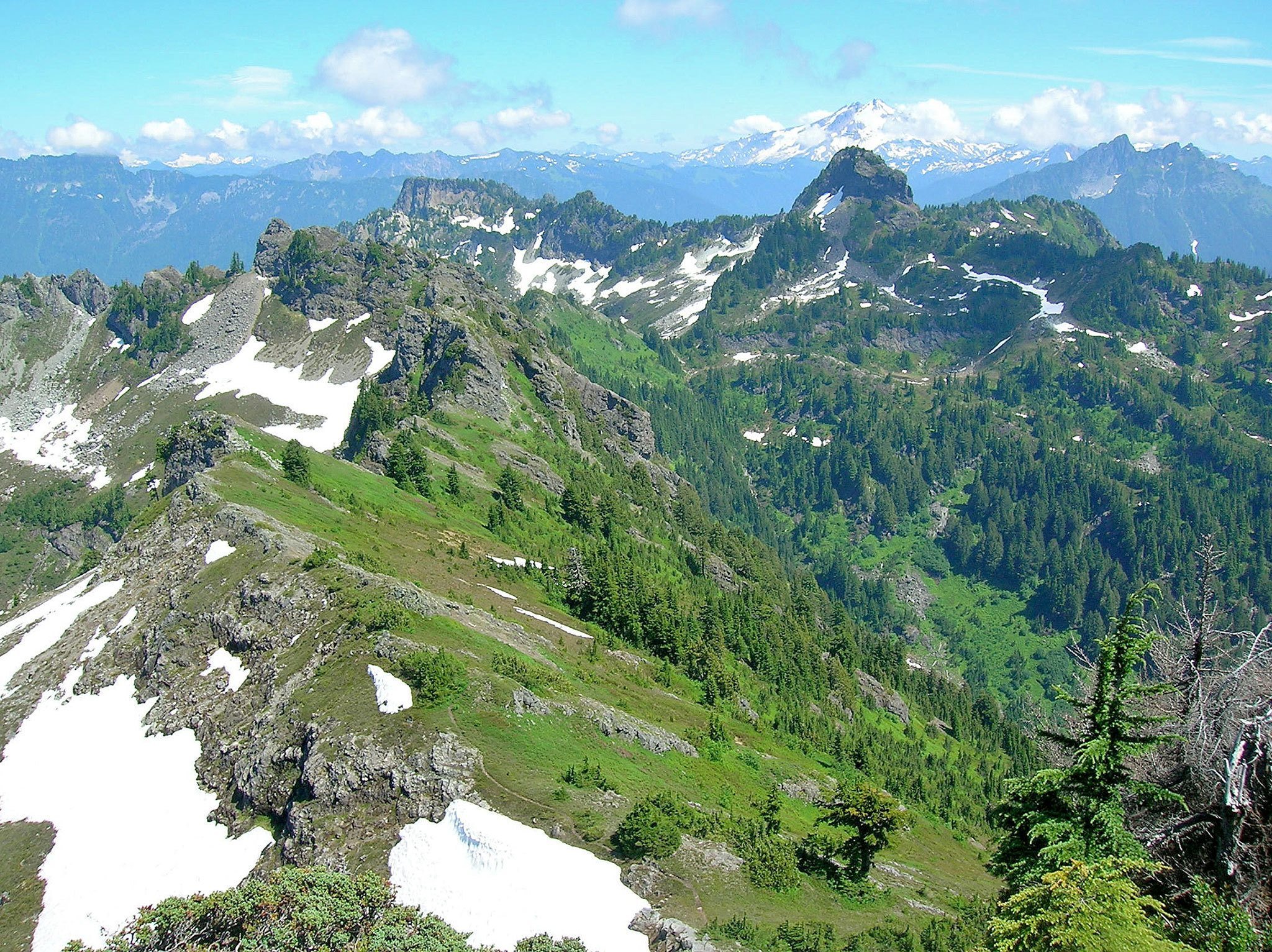
Starting low and heading high, the way to Dickerman’s 5,723-foot summit gains much elevation. But jaw-slacking views of craggy peaks near and far make every ounce of sweat expended worth it. Come here in September and let Dickerman’s legendary blueberry patches slow your upward momentum even more. “All too few trails remain outside wilderness areas and national parks that begin in valley bottoms and climb unmarred forests to meadows,” wrote Manning. Experience this mountain in all of its glory — hiking through all of its life zones.
Starting in thick timber, the way side-slopes for a minute or two before commencing into switchback rhythm. Tread can be rocky at times, a result of erosion when much of the mountain’s lower slopes went up in flames nearly a century ago. Remnant old-growth giants displaying their fire survival scars stand proudly among scrappy successive growth.
After 2 miles of continuous clambering under a dark canopy and beside and around big mossy ledges, the grade eases at a small creek crossing (dry by late summer—pack plenty of water). Welcome daylight as the way breaks out into boundless blue- and huckleberry flats (elev. 4,400 feet). After vacillating through the vacciniums, resume upward momentum.
As you crest Dickerman’s western shoulder, the summit comes into view, 1 mile away and 1,000 feet above. Winding through hemlock groves and heather meadows, the way once again steepens. But the stunning view south to Big Four, Del Campo, and the countless Monte Cristo peaks will help keep your mind off of the grind. Finally, after gaining 3,900 feet in 4.3 miles, reach the open summit.
Sheer cliffs drop from the north face, so keep dogs, children, and vertigo sufferers away from the edge. From a secure post, admire the Perry Creek Basin below, flanked by Mount Forgotten and Stillaguamish Peak. Look at all the surrounding mountains! Prominent to the north are Baker and White Chuck. To the east, it’s Pugh, Sloan, and Glacier. To the south—Big Four and Del Campo practically leap out at you, while Rainier peeks above a wall of jagged summits. To the west, Pilchuck and Three Fingers proudly stand out. No wonder this hike is so darned popular!
Talk to us
> Give us your news tips.
> Send us a letter to the editor.
> More Herald contact information.

