
EVERETT — Since last week, Snohomish County and large parts of western Washington have been under a heat advisory, but depending on if where you live is surrounded by trees, that heat may have felt very different.
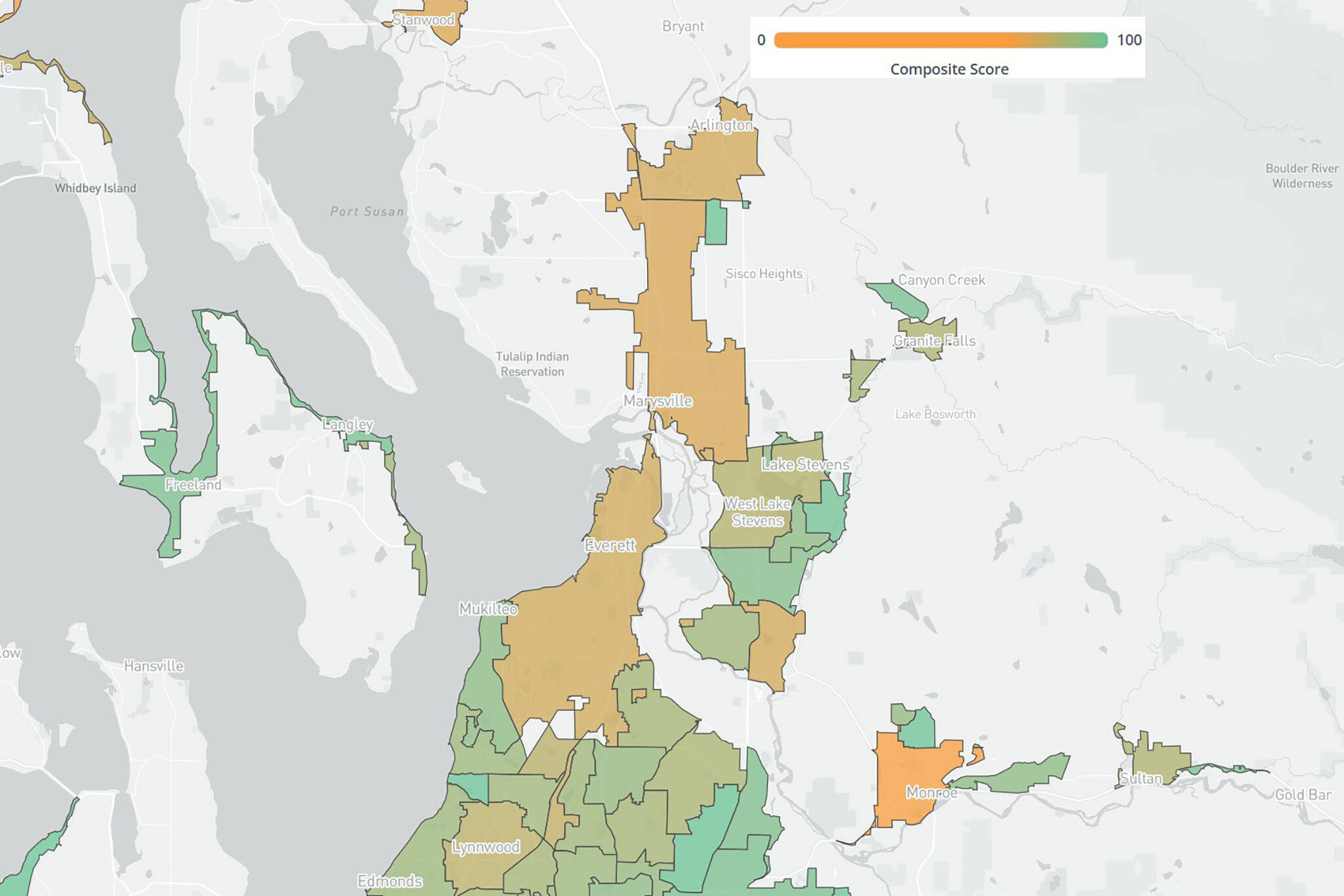
A new online map created by the Washington Department of Natural Resources and conservation nonprofit American Forests illustrates tree canopy statistics across the state, highlighting how socioeconomic disparities can play a role in shade cover and temperature hot spots.
Trees provide air and water filtration and shade sidewalks and houses, lowering utility costs and decreasing risks of heat-related illnesses, but some neighborhoods and population groups have historically missed out on these benefits due to systemic discrimination.
The map breaks neighborhoods down by census blocks, allowing viewers to see certain characteristics of the population, such as the percentage of unemployment or if residents are isolated by language barriers. The tool also shows the percentage of tree canopy in the area, assigning a tree equity score based on the combined factors out of 100 and calculating how much of an increase in canopy cover is needed for residents to feel the full benefits of an urban forest.
A new online map created by the Washington Department of Natural Resources and conservation nonprofit American Forests illustrates tree canopy statistics across the state, highlighting how socioeconomic disparities can play a role in shade cover and temperature hot spots. (American Forests)
Since partnering in 2023, the state’s natural resource department and American Forests have worked to bolster urban forestry programs across the state, in part with guidance from its Tree Equity Collaborative Steering Committee, which is made up of representatives from local governments, tribes and nonprofits.
The map, which launched last month, is the partners’ latest push to increase tree equity in the Evergreen State.
By providing free, easily digestible information, the state and American Forests hope cities and communities can leverage the site for planning, said Ben Thompson, the urban forestry program manager for Washington Department of Natural Resources.
“The real benefit of that tool is that it helps folks that are not either urban forestry professionals or GIS professionals,” Thompson said. “[They] can go in and easily understand what’s happening and where it’s happening, and get accessible information that they can use to talk about it.”
In south Lynnwood, sandwiched between Highway 99 and a section of the interurban trail, a census block received a score of 71, clocked as a high priority for increasing canopy cover.
Out of the 1,332 people within the area, 83% are people of color, 30% are isolated by language barriers and 19% live in poverty. On a hot day, the neighborhood could experience temperatures almost 10 degrees higher than nearby areas, only blocks away, with more tree coverage.
Since being hired as the city of Lynnwood’s urban forester in September 2024, Molly Henderson has been planting trees to combat current deficits. With the support of a $1.3 million grant from the federal Inflation Reduction Act, Henderson has planted 110 trees in south Lynnwood, with plans to reach 750 by 2029.
Looking at the map, Henderson said she wasn’t surprised the area along Highway 99 had low scores due to high commercial use. The city has been doing tree giveaways twice a year, she said, but is still working to increase outreach in the area.
“I can plant a ton of trees, but really, what’s going to make the biggest difference is if I can get more greenery [for] these private land owners, especially, companies,” she said, adding the city will advertise the giveaway program at Lynnwood’s upcoming Fair on 44th event on Sept. 6.
Users can plug potential planting scenarios into the tree equity map to understand how additional trees could impact the area, supporting local planners like Henderson in determining where to prioritize efforts.
“I think it’s really important that you can use this to think about where the gaps are and where you need to have improvement and where to start,” said Snohomish County Council member Megan Dunn, who is part of the Tree Equity Collaborative Steering Committee created by the state and American Forests. “These are the communities that we need to start at to make up for problems in the past.”
Eliza Aronson: 425-339-3434; eliza.aronson@heraldnet.com; X: @ElizaAronson.
Eliza’s stories are supported by the Herald’s Environmental and Climate Reporting Fund.
Talk to us
> Give us your news tips.
> Send us a letter to the editor.
> More Herald contact information.


