
VERLOT — In spring and summer, one of Snohomish County’s most beautiful places also becomes one of its most dangerous.
The Big Four Ice Caves trail in the Mount Baker-Snoqualmie National Forest offers a panoramic view of the best the North Cascades Range has to offer.
The caves also are where tons of snow, ice and rock break loose every year, a natural wonder that could bury dozens of people.
July 6 will mark a year since the partial collapse at the caves claimed the life of a California woman and her brother. Two others have been killed by falling ice since 1998, including 11-year-old Grace Tam, who was standing 20 feet from the caves.
The beauty of the site, combined with its proximity to the highway, makes for an alluring geological attraction, one that’s as easy as ever to access, despite a history of tragedy. It poses such a risk to human life that the sheriff’s office plans an annual on-site, mass-casualty drill. When it comes to emergency management, they treat the ice caves with the same level of preparedness as they would a possible jet crash at Paine Field or a crack in Culmback Dam at Spada Lake.
Police and firefighters have to brace themselves for what would happen if the caves ever completely collapsed on a busy summer day.
Every year, Bill Quistorf, the sheriff’s chief pilot, updates the emergency action plan for the caves. The 2016 version of the plan is 13 pages long. One brainstorming session for an earlier draft included the phrase, “Need bag of tourniquets.”
The U.S. Forest Service is putting up more warning signs, sending rangers to the caves on weekends and talking about rerouting the trail, to discourage people from going into the caves or climbing on the ice.
Still, hikers are humans, and humans make mistakes. So emergency responders prepare for the worst.
The plan for the caves is one of calculated risk.
As Quistorf knows, “You can’t put a fence around the Cascade Mountains.”
Unpredictable ice
The ice caves form in a gully on the north side of Big Four Mountain, east of Verlot. In wintertime, tons of debris amass from snowfall and avalanches. In the spring and summer, the shadow of the mountain shelters the deposited snow from the sun, while rising temperatures melt holes. Drafts of warm air and streams of snowmelt gradually carve impressive caverns.
Though they’re called “ice caves,” the formations at Big Four actually are a mix of snow, ice and rock. Their size, density and texture vary year to year, day to day.
Snowmelt on the north face turns into a waterfall each year that runs into the back of the ice caves. Fissures that form along the roof of the cave then become crevasses and eventually give way.
Some years, the snow is hard and mixed with rocks. Other times, “it could be soft, and you don’t know where the weak spots are,” Quistorf said.
“We’ve got such a dynamic and unknown material,” he said. “The ice of the ice caves, that’s really the challenge we’re dealing with. Every year that ice forms, and it forms differently.”
Climate and weather patterns play a big role. Changes in temperature that might seem minor to humans are significant for a massive mound of frozen water.
Temperatures have been increasing in the North Cascades since the 1950s, said Karin Bumbaco, the assistant state climatologist. The increase is modest — about a fifth of a degree Fahrenheit per decade. That’s more than random weather patterns, she said.
Meanwhile, annual spring snowpack has been decreasing at most mountain-monitoring stations, Bumbaco said.
“These (patterns) are what we would expect to see in the future, too,” she said. “Decreased snowpack, continued warming. In the whole Pacific Northwest, we’re seeing these trends.”
Always prepared
In April, first responders from around the county got together with Forest Service staff to talk about the caves. The annual on-site exercise at Big Four was canceled by a combination of bad weather and resources being diverted to a wildfire near Gold Bar.
Many of the rescuers are all too familiar with the caves. They remember July 6, 2015, when Annalisa Santana was killed. Her brother, David Santana, succumbed months later from injuries suffered that day.
They also remember July 31, 2010, when Grace Tam died.
A rescue operation at the caves is complicated and involves patched-together communications.
To start with, a hiker who needs to call 911 and doesn’t come across a field ranger must run a mile to the trailhead and then drive west about 12 miles to the nearest landline, at the Verlot Ranger Station. Cell phone service isn’t available for another 9 miles past Verlot.
The need to coordinate radio communication among more than a dozen agencies, some of whom aren’t often called to the backcountry, has caused problems in the past.
The type of handheld radios most often carried by police and firefighters aren’t compatible with the nearest radio tower, on Mount Dickerman. The remoteness requires certain radios, channels and frequencies.
The trailhead parking lots are likely to be full or at least crowded, making it harder to maneuver ambulances. Rescue helicopters and Airlift Northwest share close quarters for landing in the nearby grass.
Robe Valley firefighters expect to get there first, followed by the deputies who come from Granite Falls, about a 30-minute drive. Others know from experience the flow of information will be slow and spotty. Getting the right help rolling relies on someone providing an accurate first report.
In recent years, Quistorf and his team have made changes to the plans so Robe Valley Fire Chief Tim Bond can communicate directly with sheriff’s helicopter crews.
Knowing whether the helicopters can fly is “the key to everything,” Bond said.
If not, the plan morphs. Crews carry rescue gear on their backs. The injured are hauled out on stretchers.
Add bad weather — or nightfall — and everything slows down.
Last July, it took the county-wide technical rescue team a little more than a hour to assemble at the trailhead, ready to go.
A delicate, dangerous task
After the caves collapsed on July 6, 2015, Annalisa Santana’s body was trapped near the waterfall at the back, a football field’s distance from the mouth of the caves. The recovery team considered options.
One plan, deemed too dicey, was to hoist in crews through the hole in the roof formed by the waterfall. Another idea was lowering crews from the helicopter onto a nearby ledge, and having them rappel some 1,000 feet, Quistorf said. They’ve since talked about engaging mine-collapse experts or shoring up the roof with railroad ties. They’re also looking into buying a device that can detect heartbeats underneath 20 to 30 feet of debris.
They recovered Santana’s body on July 7, after consulting with state avalanche experts. The plan was to try to stabilize the caves by shaking loose material that was poised to collapse. From the sheriff’s helicopter, trained explosives experts aimed a dozen charges of ammonium nitrate, 60 to 90 pounds apiece. The targets were fissures in the roof of the caves, some of which were 6 inches to 10 inches wide.
With each boom, the crews on the ground could see ice collapsing from the ceiling, Quistorf said.
There wasn’t a complete collapse, but the ice was falling in a pattern — to the left and center.
To minimize the risk, it was decided that two of the most experienced rescuers would collect the body while staying to the right of the caves. It was simply too dangerous to send a team.
That was only a partial collapse.
Within a week, a picture was taken and shared with Quistorf of an even larger icefall at the caves.
“I just can’t imagine if there were 30 people inside and this happened,” he said.
Scott Goodale, a Marysville fire battalion chief, was part of the command team for last year’s rescue and recovery.
He reminded others at the April meeting that no matter how good their plans, “We have to remember there are potentially people bleeding to death in the cave, and we have to get there, and it’s a long time to get up there.”
An alternate route
The ice caves trail reopened this spring, nine months after the deadly collapse.
The Forest Service estimates that each year roughly 50,000 people visit the caves. It’s one of the most popular stops along the Mountain Loop Highway.
There’s been talk of rerouting the last stretch of the one-mile trail so it ends farther away from the caves. That could reduce the temptation for hikers to cross the boulder field in front of the snow.
The Forest Service plans to start an environmental review in 2017. They’re looking at several options for the trail, Darrington District Ranger Peter Forbes said. There will be a public comment period before anything drastic happens, he said.
“At the end of that process, we’d make a decision on what we want and where we want it,” he said.
In the meantime, the Forest Service has been sending field rangers to the caves on weekends. Between the end of April and the second week of June, those field rangers talked to more than 2,000 visitors. It gives them the chance to explain to folks the wonders and dangers of the destination.
The sight of Forest Service uniforms also may deter people from climbing on the caves or venturing inside, Forbes said.
However, warning signs, notices at the trailhead and even closed gates have failed to stop people in the past.
When the trail was closed after last year’s collapse, the Forest Service locked a gate along the path, just before the footbridge over the South Fork Stillaguamish River.
Some climbed over the gate or went around, even if it meant fording the fast-moving Stilly.
Others remember, too
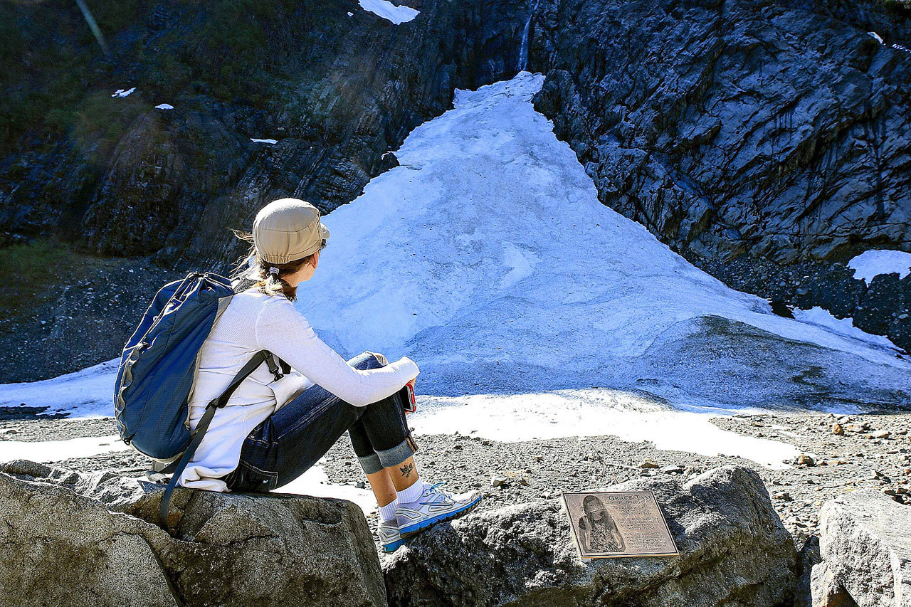
The first Saturday since the reopening was warm and sunny. Dozens of people sat on logs and boulders at the end of the trail, eating lunch or snapping photos. The caves hadn’t formed yet, but openings in the towering mounds of ice were visible.
Don Kealy, 56, and Carolyn Harris, 54, claimed a seat in a circle of rocks back from the snow. Harris grew up in Snohomish, and her dad used to take her to the ice caves as a kid. She was taught to never go inside, but she’s seen people in the caves every time she’s visited. She’s been there maybe 20 times.
The pair sat near a metal plaque with Grace Tam’s picture. It warns visitors to be cautious of Big Four’s “beautiful but always changing environment.”
Healy pointed to the plaque.
It’s a powerful reminder.
Rikki King: 425-339-3449; rking@heraldnet.com.
Talk to us
> Give us your news tips.
> Send us a letter to the editor.
> More Herald contact information.


