A lidar image of the area of the 2014 Oso mudslide. Lidar is an acronym for light detection and ranging. (Washington State Department of Natural Resources)

A lidar image of the area of the 2014 Oso mudslide. Lidar is an acronym for light detection and ranging. (Washington State Department of Natural Resources)

New maps, spurred by Oso slide, shed light on hazard areas

OLYMPIA — Washington’s Department of Natural Resources is following through with a key safety recommendation that arose in the aftermath of the Oso mudslide, as it starts to post intricate topographical maps online.

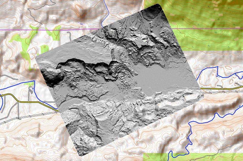
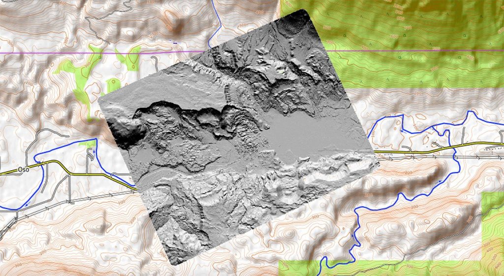
The state generates the maps through laser-imaging technology known as lidar. By showing accurate contours of the land, the aerial images help point out areas at risk for landslides, flooding, tsunamis and other natural disasters.

The maps went online last week as a beta, or test, version. DNR expects to post more on its lidar portal in the coming weeks.

“We are focusing that on populated areas and areas where there is infrastructure,” said Dave Norman, the state geologist.

The mudslide that struck near Oso in March 2014 killed 43 people in and around the Steelhead Haven neighborhood. Later that year, state and Snohomish County officials convened an expert commission to examine lessons in areas such as land-use planning and emergency response.

Among other findings, commissioners concluded that Washington lacked adequate maps to show landslide risks and other geologic hazards. The next state budget committed $36 million through 2021 to enhance DNR’s abilities to understand geological hazards through the best technology available.

So far, the DNR officials have amassed high-quality lidar data for 17,049 square miles, Norman said. That’s nearly 24 percent of the state. The DNR is partway through posting that information online. DNR’s lidar portal draws from the department’s own inventory as well as from the Puget Sound Lidar Consortium, counties and cities.

More flights are due soon to run lidar over other parts of the state. That work is likely to include Puget Sound’s coastal bluffs, where sloughing has been a regular nuisance and danger for the BNSF Railway tracks, homes and roads. That information could go online by next fall or winter, Norman said.

Lidar stands for Light Detection and Ranging. It employs lasers mounted on aircraft to scope topography by measuring reflected light. The beams can make it through tree cover and some man-made features to show the landscape below.

“The most important thing about lidar is it really provides a very accurate elevation model and image of the earth that you can’t get (otherwise) because it’s obscured by vegetation or other things,” Norman said.

The information is helpful to developers, land-use planners, emergency management officials, engineers and scientists. It provides a clearer picture of flood plains, seismic fault lines and volcanic hazard areas. Lidar images help scientists model how water might behave during tsunamis or floods.

The technology also is useful in forestry, to estimate tree growth and identify wildlife habitat. Lidar also can reveal archaeological sites hidden by tree cover.

Snohomish County planners already use lidar data from other sources to inform land-use decisions. They “will definitely use this as one more tool in the box for evaluating landslide hazard areas in the future,” said Tom Rowe, a long-time planning department manager who now works in the county executive’s office. “We have explored all of the data that’s out there. We are using all of the sites that we’re aware of.”

Similarly, the county’s emergency managers also have been putting lidar data to use and see the state data as a welcome addition.

“We’re definitely aware of it and will make use of it as able,” said Heather Kelly, a spokeswoman for the county’s Department of Emergency Management. “We use any resource we can during our planing and our incident response.”

To view the state data, go to lidarportal.dnr.wa.gov and www.dnr.wa.gov/lidar.

Noah Haglund: 425-339-3465; nhaglund@heraldnet.com. Twitter: @NWhaglund.

Talk to us

> Give us your news tips.

> Send us a letter to the editor.

> More Herald contact information.

More in Local News

More frequent service coming for Community Transit buses

As part of a regular update to its service hours, the agency will boost the frequencies of its Swift lines and other popular routes.

More than $1 million is available for housing-related programs in Snohomish County, and the Human Services Department is seeking applications. (File photo)
Applicants sought for housing programs in Snohomish County

More than $1 million is available for housing-related programs in… Continue reading

The newly rebuilt section of Index-Galena Road is pictured on Saturday, Nov. 4, 2023, near Index, Washington. (Jordan Hansen / The Herald)
Snohomish County honored nationally for Index-Galena road repair

The county Public Works department coordinated with multiple entities to repair a stretch of road near Index washed out by floods in 2006.

Birch, who was an owner surrender and now currently has an adoption pending, pauses on a walk with volunteer Cody McClellan at PAWS Lynnwood on Thursday, Aug. 7, 2025 in Lynnwood, Washington. (Olivia Vanni / The Herald)
Pet surrenders up due to rising cost of living, shelter workers say

Compared to this time last year, dog surrenders are up 37% at the Lynnwood PAWS animal shelter.

Pedestrians cross the intersection of Evergreen Way and Airport Road on Thursday, Aug. 7, 2025 in Everett, Washington. (Olivia Vanni / The Herald)
In Snohomish County, pedestrian fatalities continue a troublesome trend

As Everett and other cities eye new traffic safety measures, crashes involving pedestrians show little signs of decreasing.

The Mountlake Terrace City Council discusses the Flock Safety license plate camera system on Thursday, June 5, 2025 in Mountlake Terrace, Washington. (Olivia Vanni / The Herald)
Mountlake Terrace public express ongoing ire with future Flock system

The city council explored installing a new advisory committee for stronger safety camera oversight.

Crane Aerospace & Electronics volunteer Dylan Goss helps move branches into place between poles while assembling an analog beaver dam in North Creek on Wednesday, Aug. 6, 2025 in Everett, Washington. (Olivia Vanni / The Herald)
Adopt A Stream volunteers build analog beaver dams in North Creek

The human-engineered structures will mimic natural dams in an effort to restore creek health in an increasingly urbanized area.

Ferries pass on a crossing between Mukilteo and Whidbey Island. (Andy Bronson / Herald file)
State commission approves rate hike for ferry trips

Ticket prices are set to rise about 6% over the next two years.

1 person dead, another injured after vehicle crashes into building in Everett

Prior to the crash, two people allegedly fled from Washington State Patrol who was investigating a DUI

Logo for news use featuring Snohomish County, Washington. 220118
Snohomish County departments explain why they’re overspending

District Court, the Office of Public Defense, the Sheriff’s Office and Corrections sat in front of the county council Tuesday.

South County Fire headquarters in Everett, Washington on Thursday, May 18, 2023. (Annie Barker / The Herald)
South County Fire commissioner says board violated public meetings act

The board privately discussed staffing changes to Mill Creek’s fire station, he said. The board chair says it was within the law.

Fire Station One firefighters fill their bowls and plates with dinner on Tuesday, Dec. 10, 2024 in Everett, Washington. (Olivia Vanni / The Herald)
Everett firefighters turn on the burner and fire up the grill

From steak bites to sauteed shrimp, the crew at Station One know their way around the kitchen: “We like good food.”

Support local journalism

If you value local news, make a gift now to support the trusted journalism you get in The Daily Herald. Donations processed in this system are not tax deductible.