By Zach Urness
Statesman Journal
PROSPECT — In the minds of most kayakers and rafters, the Rogue River begins at Lost Creek Lake.
Southern Oregon’s iconic river is impounded not far from its birthplace and transformed into a 10-mile reservoir that allows close regulation of the river’s lower 157 miles, including its world-famous “wild section” between Grants Pass and Gold Beach.
Built in 1977, the reservoir decreases flooding, cools water for salmon and steelhead, and provides predictable water levels for anglers, rafters and jet boaters. In many ways, Lost Creek helps make the Rogue an economic powerhouse for recreation.
And yet …
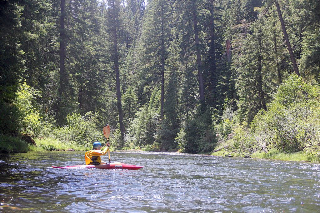
There’s something deeply satisfying about setting your boat on the upper river — above the reservoir — and experiencing the Rogue in its infancy.
Fast and reckless, jade-green and ice-cold, the Upper Rogue squeezes through lava tubes, roars into basalt canyons and drops off multiple waterfalls in a lush, sweet-scented forest of ponderosa pine and Douglas fir.
The thrill of hurtling into complex, punishing rapids and rolling peacefully below towering trees on this immature river is one of my favorite whitewater experiences in Oregon.
Officially known as the North Fork Rogue, this spring-fueled stream is one of the few free-flowing rivers that can be kayaked into late summer.
Despite that, the North Fork Rogue gets little use from boaters. No outfitters run this stretch of river — permits are not available — and the put-in spot is a long way from Oregon’s major population centers. On most days, you’ll be the only group on the river.
“The North Fork is largely unknown and has great Class III and IV rapids through a beautiful canyon,” said Zach Collier, owner of Northwest Rafting Company and a writer for WhitewaterGuidebook.com. “Most rapids are pretty straightforward Class III, but there are some tricky Class IV rapids that require strong eddy-catching skills so you can get out and scout the rapid.”
While it’s mostly experienced hard-shell kayakers that run this stretch of river, a handful of inflatable kayakers also tackle the North Fork. Doing your homework — knowing which sections of river match your ability level — are important to determine before putting your boat on the river.
The book “Soggy Sneakers: A Paddler’s Guide to Oregon’s Rivers” and the website Whitewater Guidebook are good places to start, but kayaking with people who’ve experienced the river is always the best way to start.
River Bridge run
There are multiple options to choose from on the North Fork Rogue, but the best introductory run is the 5 miles from River Bridge Campground to North Fork Reservoir.
Considered by most a Class III run — with a few borderline Class IVs — there are enough complex rapids and potential dangers that a strong background in whitewater is recommended.
In early July, I headed down to the River Bridge section with my friend Jim. Even though it was almost 80 degrees, we wore full-body drysuits because, yes, the water really is that cold.
The river started out mellow, bouncing across rocky bars below a forest of ponderosa pine and Douglas fir that seem to bend inward toward the river. No houses line the river here, and the highway is far enough away that it creates a wilderness-like experience.
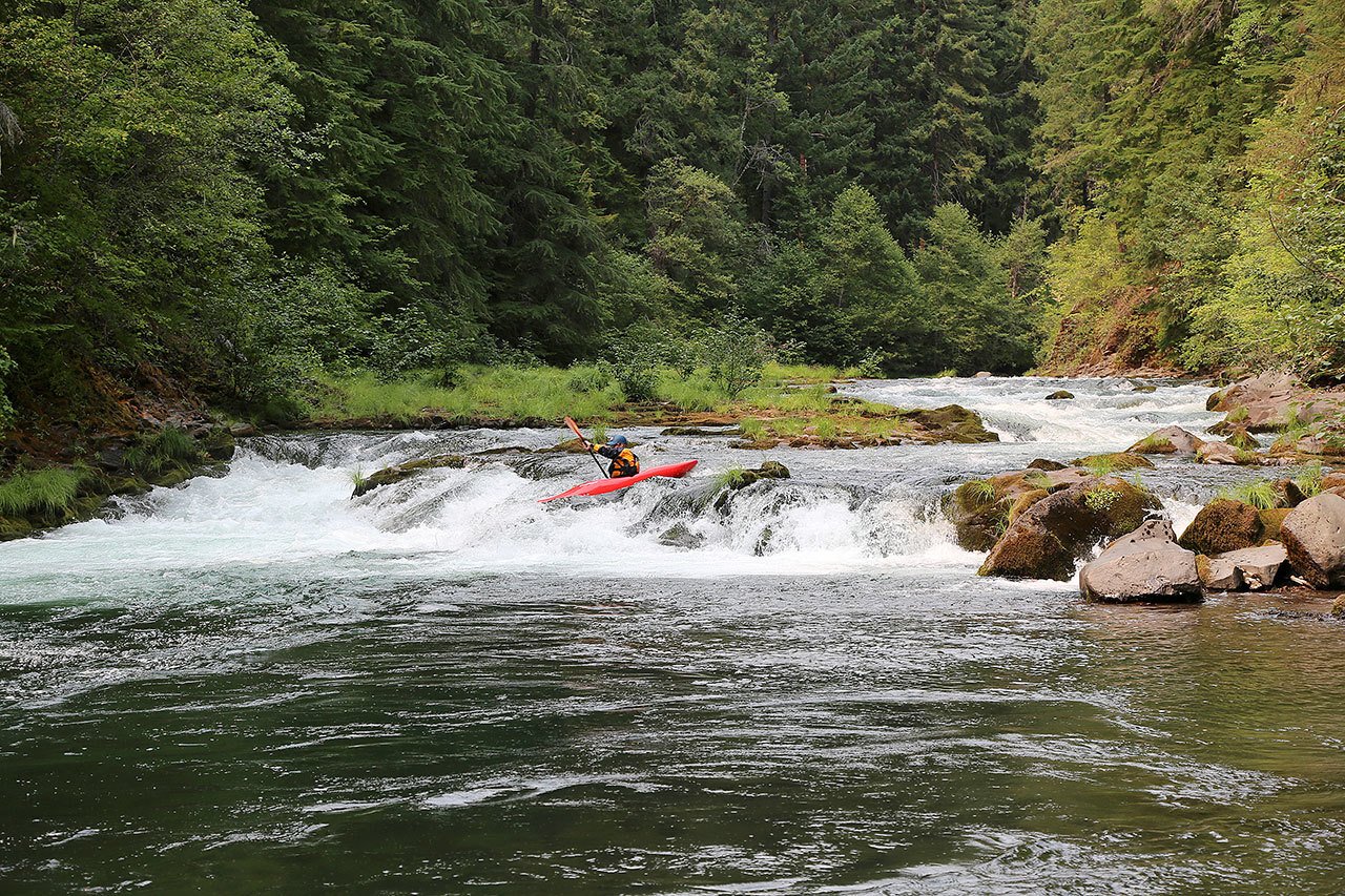
After about a mile and a half, we reached the beginning of the collection of Class III+/IV rapids.
We decided to stop and scout the first major rapid — a left turn and river-wide drop called “Second Ledge” — and were immediately glad we did.
Two downed trees obscured the main channel, and more trees laid across the ledge. We decided to play it safe and portage around the rapid, carrying our boats through thick forest to a beach at the bottom of the ledge.
The next major rapid is known as “Swirly Chute” — a pretty apt name — but we came to what’s probably the most challenging (and fun) rapid at mile 2.1.
“Right or Left” rapid, Class IV, is pretty self-explanatory. After entering a big wave train, the river splits in two directions. Choose left, and you’ll need to launch off a decent sized drop. Choose right, and you’ll need to make a sweeping turn before dropping down a narrow, boiling chute.
I chose right and, despite getting turned around for a moment, managed to make it through the chute without getting flipped.
The whitewater didn’t let up, with three more steep boulder gardens that required swift rock dodging. One of them, “Mystery Door,” requires you to basically come to the edge of a big drop, quickly pick a line and go before the river pushes you over.
At last, the river gives out, as the North Fork Dam backs the reservoir up for the final half mile of paddling. The forest is beautiful here, and it’s a nice, peaceful way to end a day on the fast and thrilling river.
Natural bridge
If the River Bridge section leaves you wanting more, a step up in terms of difficulty is from Natural Bridge to Woodruff Bridge campgrounds. This run is just 3 miles but is a step up in terms of beauty and challenge.
A 20-foot waterfall, Knob Falls, must be portaged.
Mill Creek section
Yet another step up in terms of beauty and difficulty begins in the small town of Prospect, below a 173-foot Mill Creek Falls. A Class IV+ section of steep and very fast whitewater, this 3-mile run ends in Lost Creek Lake.
Takelma gorge
Only experts navigate this steep-walled gorge of Class IV+ whitewater. Certainly worthwhile if you’ve got the ability.
Zach Urness has been an outdoors writer, photographer and videographer in Oregon for eight years. He is the author of the book “Hiking Southern Oregon” and can be reached at zurness@StatesmanJournal.com or 503-399-6801.
North Fork Rogue River (Upper Rogue)
Location: Prospect / Union Creek area on Highway 62 north of Medford
Activities: Whitewater kayaking
Kayaking run: River Bridge Campground to North Fork Reservoir
Difficulty: Class III+/IV
Distance: 5 miles
When open: Year-round
Helpful information: The book “Soggy Sneakers: A Paddler’s Guide to Oregon Rivers” or the website whitewaterguidebook.com/oregon/north-fork-rogue-river/
Get started: To get started with kayaking a river such as the NFMF Willamette, consider contacting or joining a group like the Willamette Kayak and Canoe Club (wkcc.org).
Put-in spot: River Bridge Campground (8 miles south of Union Creek; follow signs to campground and river access)
Take-out spot: North Fork Reservoir park (14 miles south of Union Creek; turn right on dirt road just before Prospect to North Fork Reservoir park)
Talk to us
> Give us your news tips.
> Send us a letter to the editor.
> More Herald contact information.
Gallery