Sore legs, cool pictures and a sense of accomplishment are usually all I take away from a hike.
But Mount Margaret, a 6-mile trek in the Cascade Range near Snoqualmie Pass, was far more memorable.
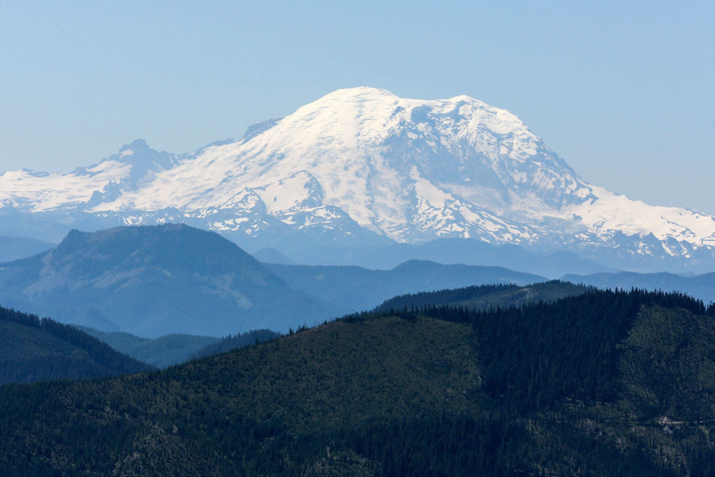
There’s a piece of history up there — geocaching history, that is — as well as some unforgettable views of Mount Rainier, wilderness and lakes from a perch of 5,100 feet.
I’m no geocacher, so I tagged along with local expert Rich Schleifer, 50, of Mill Creek, who has found 2,495 geocaches, and fellow geocacher Jeff Harmon 47, of Lynnwood, and their families.
But to reach the peak, we had to navigate steep terrain, repel clouds of bugs and hike trails that come dizzyingly close to cliff edges.
Like I said, it was memorable.

Mount Rainier looms large on the Mount Margaret trail near Snoqualmie Pass. (Kevin Clark / The Herald)
If you’ve never heard of geocaching, think of it as a treasure hunt. “Caching,” as its fans call it, involves tracking down hidden objects using GPS coordinates posted on a website. X marks the spot for things like ammo containers, film canisters or matchboxes. Geocachers store “treasure” inside them — just trinkets, nothing valuable — as well as logbooks for others to sign.
An estimated 3,500 geocachers have endured the Mount Margaret trail’s moderate difficulty and countless mosquitoes so they can find the oldest geocache in Washington — known as “GCD” — since it was hidden by a pair of hikers on June 21, 2000. August is the hike’s peak month.
GCD is the 15th oldest cache in the world (out of 3.2 million on record). Its celebrity status makes it a destination vacation for avid geocachers; since 2012, visitors from 89 countries have hiked the mountain to find it, including from Germany, Great Britain, Sweden, Finland, France and the Czech Republic.
“The Pacific Northwest has some of the most sought-after caches anywhere,” said Abby Wolfe, who maintains the Mount Margaret geocache. “Since geocaching was born here, GCD is one of them. Because so many people visit it from around the world, and winters in the Cascades can be rough, I have to make sure the cache stays in good physical condition.”
Wolfe, 61, of Newcastle, is the former president of Washington State Geocaching Association, and has more than 16,000 finds since taking up the hobby in 2003. She adopted GCD in 2011.

Rich Schleifer, followed by his daughter Hinako, 13, hike the Mount Margaret trail in search of geocaches. (Kevin Clark / The Herald)
The hike begins at 3,520 feet with a steady uphill climb on a wide gravel road before it turns left onto a dirt trail. Then it’s a switchback slog up the mountain for the next mile or so until you reach a forested area.
Our party stopped a few times during the ascent to find other geocaches besides GCD that are hidden along the trail. The breaks allowed me to admire some amazing views of Keechelus Lake along I-90 and the Alpine Lakes Wilderness.

The search party also found three other geocaches on the Mount Margaret trail. (Kevin Clark / The Herald)
Schleifer and his daughter, Hinako, 13, found GCD last summer, so they let Jeff Harmon, who had more than 550 finds since he started geocaching last year, take the lead. The quickest way to get to it was charging up a hill through bushes and branches, but the easier route follows a ridgeline trail that leads down to the spot. We chose the fast way.
Harmon’s son, William, 8, was the one to spot it first. “I found it!” he yelled.
The Harmon family gathered around the cache and played a Japanese version of rock-paper-scissors to see who would open it. William won.
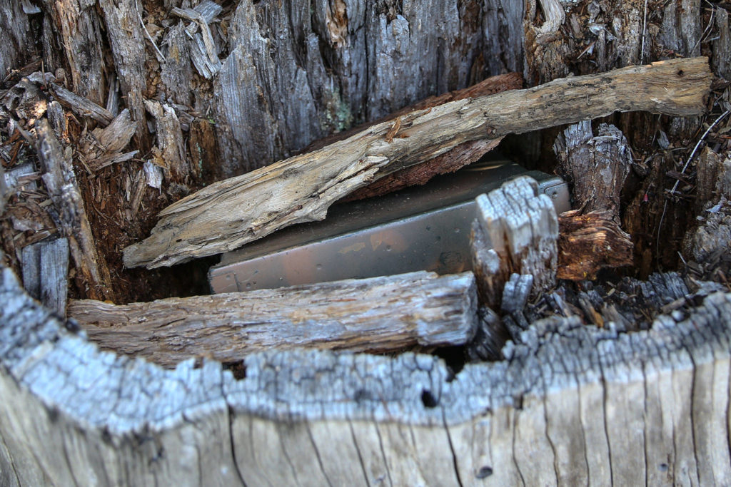
Inside the cache — a .30-caliber ammo container — were various mementos, including a yellow whistle with a smiley face, a small toy squid and geocoins, which are trackable medallions.

The geocache was hidden nearly 20 years ago and has been found an estimated 3,500 times. (Kevin Clark / The Herald)
Even Schleifer couldn’t help but be giddy as he looked inside the cache. He said it’s a milestone for geocachers.
“A lot of people, if they’ve been caching for a long time, will want to do this,” Schleifer said.
With GCD found, we continued on to Mount Margaret’s summit. After a mile walk — marred by a mosquito attack that left me with at least a dozen bites despite my long pants, long-sleeved shirt and bug spray — we reached the final ascent to the top.
The steep trail felt nearly vertical at times. Walking sticks helped. That was followed by a stretch on a ridgeline that was easy enough, but the final approach was on the edge of a sheer drop. I walked as carefully as I could and tried not to think about the danger.
The view from the summit was worth the effort and, for me, the scares. Mount Rainier dominated the landscape, and I saw nothing but alpine wilderness and blue-green lakes in all directions.
Looking back from where we hiked, I noticed beautiful purple and pink wildflowers blanketing the cliffside.
After seeing all of that, the bug bites didn’t bother me so much.
Evan Thompson: 425-339-3427, ethompson@heraldnet.com. Twitter: @ByEvanThompson.
If you go
Mount Margaret’s trailhead is easy to find. Travel east on I-90 to exit 54. From the exit, turn left, cross under the freeway, then turn right onto a narrow paved road. Drive east, parallel to the freeway, for 1 mile. The paved road becomes a switchbacking dirt road that is in poor condition. The parking lot is located at the sixth switchback. A Northwest Forest Pass is required. For more information, go to at www.wta.org.
Talk to us
> Give us your news tips.
> Send us a letter to the editor.
> More Herald contact information.
Gallery