A seismic station at Anaktuvak Pass in Alaska’s Brooks Range. The station sends earthquake information in real time. A seismometer rests at the bottom of a borehole and a fiberglass hut equipped with solar panels protects the station power system, electronics and radio telemetry equipment. (Incorporated Research Institutions for Seismology via AP)

A seismic station at Anaktuvak Pass in Alaska’s Brooks Range. The station sends earthquake information in real time. A seismometer rests at the bottom of a borehole and a fiberglass hut equipped with solar panels protects the station power system, electronics and radio telemetry equipment. (Incorporated Research Institutions for Seismology via AP)

Agency takes tectonics study to earthquake-prone Alaska

By Dan Joling / Associated Press

ANCHORAGE, Alaska — Alaska averages 40,000 earthquakes per year, with more large quakes than the other 49 states combined, and America’s shakiest state is about to have its ground examined like never before.

A federal agency that supports basic science research is completing installation in Alaska of an array of seismometers as part of its quest to map the Earth’s upper crust beneath North America.

When the magnitude 9.2 Great Alaska Earthquake ripped through the state in 1964, there were two seismometers in Alaska. At the end of this summer, there will be 260, swathing the state with instruments that record seismic waves and give geologists a picture of the upper 50 miles (80 kilometers) of the Earth. Alaska state seismologist Michael West calls it a “big freaking deal.”

ADVERTISEMENT
0 seconds of 0 secondsVolume 0%
Press shift question mark to access a list of keyboard shortcuts
00:00
00:00
00:00
 

“This footprint of instrumentation rolled across the country and is now wrapping up this grand, 15-year project” in Alaska, West said. The seismographs are deployed for the National Science Foundation by a consortium of U.S. universities that acquires and distributes seismological data.

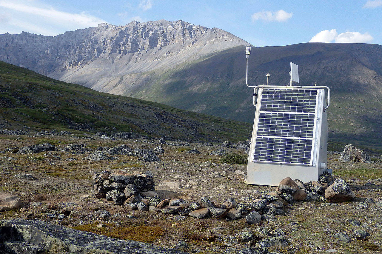
Engineering them for Alaska was a challenge.

A helicopter flies in a lightweight drill rig to dig into bedrock or permafrost for the seismograph, said Bob Busby, transportable array manager for Incorporated Research Institutions for Seismology.

Solar panels mounted on fiberglass huts must gather energy throughout summer to charge lithium iron phosphate batteries — equivalent to two or three batteries in a Prius — that power equipment through the long winter.

The array of seismometers, part of the science foundation’s EarthScope project, has the ambitious goal of explaining how continents formed as well as something of more immediately interest: where dangerous earthquakes of the future may occur.

It’s tied to the theory of plate tectonics, which holds that Earth’s rigid outer layer is broken into large, mobile plates, like pieces of shell on a hard-boiled egg, if the shell pieces moved along, over and under each other.

Tectonic plates average 50 miles (80 kilometers) thick and move only as fast as fingernails grow. But when they intersect, pressure builds until plates slip, causing earthquakes and volcanoes.

“Any kind of ground shift is somehow related to the tectonic plates,” said Maggie Benoit, EarthScope science program director.

The study of plate tectonics is only about 40 years old, Benoit said, and the National Science Foundation made a quarter-billion-dollar commitment to advance the field.

Alaska is especially active, with 11 percent of the world’s earthquakes every year, because it’s located where two great plates converge, with the Pacific Plate slowly being pushed under the North American Plate.

There are three big pieces to EarthScope. One is a borehole into the San Andreas Fault to understand fault structure. A second is a series of GPS stations that document plate movement.

The third part is USArray, the network of hundreds of portable seismographs. The array was placed first in western states and over a decade moved east to other states. In the Pacific Northwest, the data has contributed to imaging chambers of molten rock at Mount St. Helens. Scientists in California are using GPS data to study groundwater use. A Brown University researcher is using data to study the formation of North America in southern and eastern states.

Alaska is more than twice the size of Texas but has nearly 350,000 fewer people than Rhode Island. Earthquakes that would devastate cities elsewhere often go unnoticed in Alaska because they occur in the Aleutian Islands or other sparsely inhabited areas.

The 260 seismic stations in Alaska will be about 50 miles (80 kilometers) apart. For added value, many are piggybacked with equipment to monitor weather and soil temperatures.

“That wasn’t the original goal,” West said. “But frankly, if you’re going to go out and plop down a power system and real-time communications to some remote locations, you might as well hang a bunch of widgets off of it.”

West said it’s interesting to think about the evolution of the Earth over 100 million years, but his use of the data will be for less theoretical purposes.

Every public structure, he said, uses building codes created on historical earthquake data. The data helps set insurance rates and design tsunami evacuation zones for Alaska coastal communities. Companies routinely make hundred-million-dollar design decisions for mines, pipelines and ports based on knowledge of earthquake hazards.

“If they know what the hazard is, they can build to it,” West said.

Talk to us

> Give us your news tips.

> Send us a letter to the editor.

> More Herald contact information.

More in Local News

Snohomish County Health Department Director Dennis Worsham on Tuesday, June 11, 2024 in Everett, Washington. (Olivia Vanni / The Herald)
Snohomish County Health Department director tapped as WA health secretary

Dennis Worsham became the first director of the county health department in January 2023. His last day will be July 3.

Julia Zavgorodniy waves at her family after scanning the crowd to find them during Mariner High School’s 2025 commencement on Friday, June 13, 2025, at Angel of the Winds Arena in Everett, Washington. (Olivia Vanni / The Herald)
‘Dream without limit’: Thousands of Snohomish County seniors graduate

Graduations at the arena conclude this weekend with three Everett high schools on Saturday and Monroe High School on Sunday.

Police Cmdr. Scott King answers questions about the Flock Safety license plate camera system on Thursday, June 5, 2025 in Mountlake Terrace, Washington. (Olivia Vanni / The Herald)
Mountlake Terrace approves Flock camera system after public pushback

The council approved the $54,000 license plate camera system agreement by a vote of 5-2.

Cascadia College Earth and Environmental Sciences Professor Midori Sakura looks in the surrounding trees for wildlife at the North Creek Wetlands on Wednesday, June 4, 2025 in Bothell, Washington. (Olivia Vanni / The Herald)
Cascadia College ecology students teach about the importance of wetlands

To wrap up the term, students took family and friends on a guided tour of the North Creek wetlands.

Community members gather for the dedication of the Oso Landslide Memorial following the ten-year remembrance of the slide on Friday, March 22, 2024, at the Oso Landslide Memorial in Oso, Washington. (Ryan Berry / The Herald)
The Daily Herald garners 6 awards from regional journalism competition

The awards recognize the best in journalism from media outlets across Alaska, Idaho, Montana, Oregon and Washington.

Edmonds Mayor Mike Rosen goes through an informational slideshow about the current budget situation in Edmonds during a roundtable event at the Edmonds Waterfront Center on Monday, April 7, 2025 in Edmonds, Washington. (Olivia Vanni / The Herald)
Edmonds mayor recommends $19M levy lid lift for November

The city’s biennial budget assumed a $6 million levy lid lift. The final levy amount is up to the City Council.

A firefighting helicopter carries a bucket of water from a nearby river to the Bolt Creek Fire on Saturday, Sep. 10, 2022, on U.S. 2 near Index, Washington. (Ryan Berry / The Herald)
How Snohomish County property owners can prepare for wildfire season

Clean your roofs, gutters and flammable material while completing a 5-foot-buffer around your house.

(City of Everett)
Everett’s possible new stadium has a possible price tag

City staff said a stadium could be built for $82 million, lower than previous estimates. Bonds and private investment would pay for most of it.

Jennifer Humelo, right, hugs Art Cass outside of Full Life Care Snohomish County on Wednesday, May 28, 2025 in Everett, Washington. (Olivia Vanni / The Herald)
‘I’ll lose everything’: Snohomish County’s only adult day health center to close

Full Life Care in Everett, which supports adults with disabilities, will shut its doors July 19 due to state funding challenges.

‘No Kings’ rallies draw thousands to Everett and throughout Snohomish County

Demonstrations were held nationwide to protest what organizers say is overreach by President Donald Trump and his administration.

Marysville is planning a new indoor sports facility, 350 apartments and a sizable hotel east of Ebey Waterfront Park. (Olivia Vanni / The Herald)
New report shifts outlook of $25M Marysville sports complex

A report found a conceptual 100,000-square-foot sports complex may require public investment to pencil out.

Logo for news use featuring Snohomish County, Washington. 220118
Snohomish County Board of Health looking to fill vacancy

The county is accepting applications until the board seat is filled.

Support local journalism

If you value local news, make a gift now to support the trusted journalism you get in The Daily Herald. Donations processed in this system are not tax deductible.