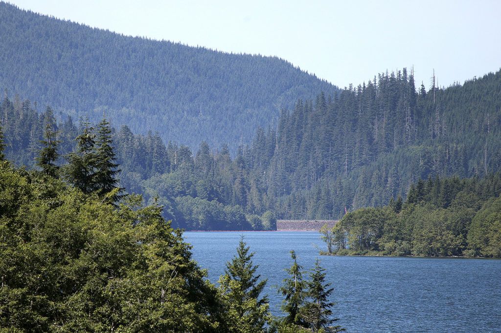
SULTAN — The water level at Spada Lake Reservoir has risen 21 feet in the past month due to heavy rains.
It’s already shaping up to be one of the wettest months on record. So far 3.41 inches of rain have fallen this month in Everett, already more than the average of 3.08 inches for February, according to the National Weather Service. At Spada, 14.65 inches have fallen since Feb. 1, when the monthly average is just above 15 inches.
The lake’s elevation, 1,431 feet, is now 19 feet below the level of the Culmback Dam’s spillway.
The dam is safe and unlikely to experience a disaster similar to what’s been happening in northern California, according to the Snohomish County Public Utility District.
At the Oroville Dam north of Sacramento, heavy rains led operators to use both the main and emergency spillways to draw down the reservoir’s level. But the huge volume of water caused both spillways to erode, and the threat of a catastrophic failure at the dam prompted the temporary evacuation of up to 188,000 people downriver.
A new storm is expected to move into that area this weekend, putting more pressure on the tallest dam in the United States.
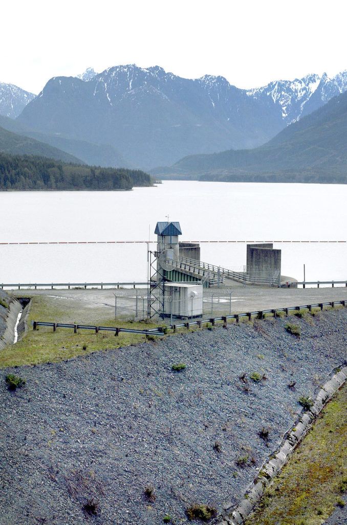
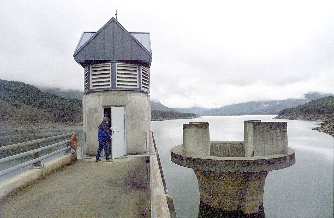
The PUD’s Culmback Dam is an earth-filled dam with a clay core that sits in a narrow canyon of the Sultan River, about 17.5 miles upstream of the city of Sultan and the Skykomish River. The PUD has put in place several safeguards to help prevent a catastrophe.
For one, Culmback uses a different kind of spillway than the concrete chute that failed in California.
The morning glory spillway at Culmback is a concrete tower 90 feet in diameter behind the dam, with a 35-foot-diameter pipe running down its center. It works like a bathtub drain: When the water level in Spada Lake reaches 1,450 feet of elevation, 20 feet below the crest of the dam, it flows into the pipe, straight down to a tunnel through the bedrock to empty into the Sultan River below the dam.
The spillway has the ability to divert 60,000 cubic feet of water per second (CFS), and it’s never been used to full capacity.
“Not even close,” said Mark Flury, the principal engineer in the PUD’s generation division.
The largest volume water that has ever been sent through it was 17,000 CFS during a 1991 storm. Downtown Sultan also experienced flooding during that storm from the Skykomish and Sultan rivers, but the flood crested before the spillway released its water, Flury said.
“It takes stormwater some time to concentrate” behind the dam, Flury said.
Spada Lake is the source of drinking water for about 80 percent of Snohomish County. Water from the reservoir also spins turbines at the Jackson Hydroelectric Project downstream, providing about 5 percent of the PUD’s power.
It’s an ideal location because the reservoir gets an average of 162 inches of rain per year, compared with just 38.44 inches annually in the Everett area.
Culmback was built to its present height of 262 feet in 1984, after the federal government’s Dam Safety program was created in response to the failure of the Teton Dam in Idaho in 1976.
That means that the PUD works closely with federal regulators to inspect the dam regularly. It also maintains an emergency response plan for many scenarios, from as small as letting water through the spillway up to a catastrophic breach.
The PUD also stays in contact with downstream communities.
“If you start to use your spillway, you start notifying people downstream,” Flury said.
Sultan Fire Chief Merlin Halverson is the key point of contact between the PUD and people living in the Sky Valley.
“The first phone call comes to me, so I can set the sirens off,” Halverson said. “Whenever there is excessive rainfall or the water behind the dam is nearing the spillway, I’m in constant contact.”
If there was any kind of failure, the city and areas downstream would be evacuated as a precaution. New warning sirens were installed in Sultan in 2014, and automated phone calls would go out to the entire community.
“If the dam has a total collapse, we’d have 45 minutes, and from there we’d have a 45-foot wall of water in town,” Halverson said.
A dedicated evacuation route leads up the hill behind Sultan High School to Loves Hill Drive. A general evacuation drill for the community is held every five years, and one for the school is held annually.
“We can evacuate the school in under 20 minutes now,” Halverson said.
According to the PUD’s inundation maps, the leading edge of a flood from a dam breach would reach Monroe in two-and-a-half hours. Snohomish is six hours downriver, and the flood would reach the U.S. 2 trestle in a little under eight hours.
That’s unlikely, Halverson said. In dam failures, the dam usually doesn’t fail completely all at once.
The intensity of flooding would depend on the size of the breach, the level of the river below, and weather conditions throughout the watershed.
In wet weather, the peak flow from a breach could be enough to inundate all of Sultan, the western half of Monroe, parts of Snohomish east of the Pilchuck River, and parts of Everett along the Snohomish River.
The PUD’s maps are about 10 years old, however, spokesman Neil Neroutsos said. They’re only intended to provide approximate estimates to help establish evacuation routes.
For example, the maps don’t reflect the ground level being raised when construction started on Everett’s Riverfront development. The PUD stays in communication with local governments to make sure everyone is up to date.
“We do everything possibly in our control to make this safe,” Neroutsos said.
Chris Winters: 425-374-4165; cwinters@heraldnet.com. Twitter: @Chris_At_Herald.
Talk to us
> Give us your news tips.
> Send us a letter to the editor.
> More Herald contact information.
Gallery