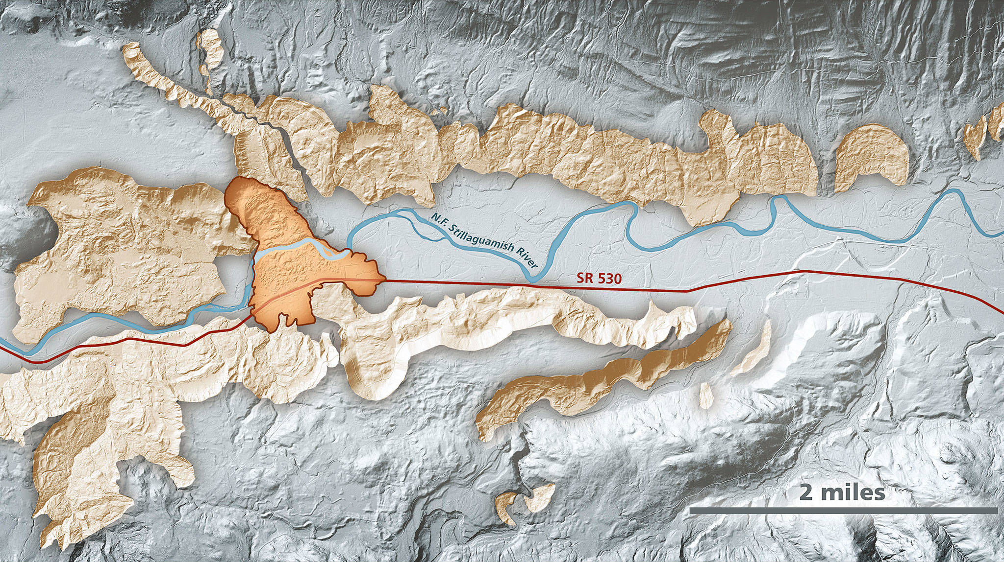
Lidar imagery enables geologists to accurately identify landslides, such as the area around the Highway 530 Oso landslide. In this area, lidar data show prehistoric landslides in beige along the North Fork Stillaguamish River. The darker-shaded, outlined area is the extent of the March 2014 Oso landslide. (Daniel Coe/Washington State Department of Natural Resources)

Lidar imagery enables geologists to accurately identify landslides, such as the area around the Highway 530 Oso landslide. In this area, lidar data show prehistoric landslides in beige along the North Fork Stillaguamish River. The darker-shaded, outlined area is the extent of the March 2014 Oso landslide. (Daniel Coe/Washington State Department of Natural Resources)

State plugs away at mapping landslide-prone areas

The DNR wants to study the area around the Oso slide and similar terrain across the state.

OSO — Nearly five years after a massive mudslide swept across the Stillaguamish Valley, claiming dozens of lives, state geologists still are trying to get a better grasp of the area’s natural hazards.

Mapping and analysis have been ongoing and will be for years to come. It’s an effort not only in Snohomish County but for the entire upper half of Washington, where glaciers carved out similar landscapes.

“There are a lot of questions that need to be answered,” state geologist Dave Norman said. “Why did it move so far? Why did it run out so quickly?”

The Department of Natural Resources has requested $1.4 million to study the Highway 530 corridor over the next two years and $1.1 million for the two years after that. The money would pay for two geologists to research, map and monitor the 50-square-mile corridor around the site of the Oso, according to the DNR’s budget request. The research would help scientists figure out how to go about studying landslide risks across 18 counties in northern Washington with similar glacial geology.

Gov. Jay Inslee did not include the money in his recommended 2019-2021 budget. The DNR has put in the same request to state lawmakers, who are working to draft a final spending plan this spring.

The Oso mudslide struck on the morning of March 22, 2014. A hillside collapsed above the North Fork Stillaguamish River, sending earth, water and trees southward. Centered on the Steelhead Haven neighborhood, the slide killed 43 people, took out a stretch of highway and covered a square mile in debris.

The scale of the disaster caught experts and laypeople off guard, though there’s evidence that slopes to either side of the valley have been sliding for thousands of years.

“Just about every major river valley that comes out of the Cascades and flows into the Sound, you have very similar situations as the north fork of the Stillaguamish,” Norman said.

In the aftermath of the deadly slide, Inslee’s office and then-Snohomish County Executive John Lovick convened an expert commission to chart a better course for understanding and reacting to landslide dangers. Among the panel’s recommendations in December 2014 was to “significantly expand data collection and landslide mapping efforts” for landslide hazards.

The highest priority areas included the Everett-Seattle rail line, highways through the Cascade Range and densely populated regions.

The state has made progress, though the program has never received quite as much money as anticipated.

A major tool has been lidar imagery. The three-dimensional maps of the Earth’s surface are created using airplane-mounted lasers. They can reveal features obscured by trees and buildings. In addition to landslides, the images are useful for identifying areas at risk for flooding, tsunamis and other natural disasters, according to the DNR.

“We’ve gathered it all up into one place and one portal,” Norman said. “It wasn’t necessarily publicly available. The portal has been a huge success.”

The DNR’s potential work in the Stillaguamish Valley over the coming years would require boots on the ground, in addition to aerial imagery. Scientists would like to complete more bore-hole testing to better understand the area’s geology, said Stephen Slaughter, the DNR’s landslides hazards program manager.

The DNR continues to release better landslide information for the whole state. In January, the agency published an inventory of 2,838 landslides in King County using new lidar images. Many of those slides were found along Puget Sound bluffs, rivers and mountains, according to a press release. That number doesn’t include smaller landslides, like the kind that block roads after heavy rains.

The state has completed similar landslide inventories for Pierce County and the Columbia Gorge, Slaughter said. The next inventories state geologists expect to complete are for Whatcom and Skagit counties, with Snohomish County likely to follow in 2020.

“We’d like to complete the entire state,” Slaughter said.

Land isn’t static. Norman, the state geologist, said he’d like to have fresh yearly images along the North Fork Stillaguamish River.

“If you do this frequently enough, you can do this as a change analysis,” he said. “That would indicate movement.”

Noah Haglund: 425-339-3465; nhaglund@heraldnet.com. Twitter: @NWhaglund.

Talk to us

> Give us your news tips.

> Send us a letter to the editor.

> More Herald contact information.
More in Local News

More frequent service coming for Community Transit buses

As part of a regular update to its service hours, the agency will boost the frequencies of its Swift lines and other popular routes.

More than $1 million is available for housing-related programs in Snohomish County, and the Human Services Department is seeking applications. (File photo)
Applicants sought for housing programs in Snohomish County

More than $1 million is available for housing-related programs in… Continue reading

The newly rebuilt section of Index-Galena Road is pictured on Saturday, Nov. 4, 2023, near Index, Washington. (Jordan Hansen / The Herald)
Snohomish County honored nationally for Index-Galena road repair

The county Public Works department coordinated with multiple entities to repair a stretch of road near Index washed out by floods in 2006.

Birch, who was an owner surrender and now currently has an adoption pending, pauses on a walk with volunteer Cody McClellan at PAWS Lynnwood on Thursday, Aug. 7, 2025 in Lynnwood, Washington. (Olivia Vanni / The Herald)
Pet surrenders up due to rising cost of living, shelter workers say

Compared to this time last year, dog surrenders are up 37% at the Lynnwood PAWS animal shelter.

Pedestrians cross the intersection of Evergreen Way and Airport Road on Thursday, Aug. 7, 2025 in Everett, Washington. (Olivia Vanni / The Herald)
In Snohomish County, pedestrian fatalities continue a troublesome trend

As Everett and other cities eye new traffic safety measures, crashes involving pedestrians show little signs of decreasing.

The Mountlake Terrace City Council discusses the Flock Safety license plate camera system on Thursday, June 5, 2025 in Mountlake Terrace, Washington. (Olivia Vanni / The Herald)
Mountlake Terrace public express ongoing ire with future Flock system

The city council explored installing a new advisory committee for stronger safety camera oversight.

Crane Aerospace & Electronics volunteer Dylan Goss helps move branches into place between poles while assembling an analog beaver dam in North Creek on Wednesday, Aug. 6, 2025 in Everett, Washington. (Olivia Vanni / The Herald)
Adopt A Stream volunteers build analog beaver dams in North Creek

The human-engineered structures will mimic natural dams in an effort to restore creek health in an increasingly urbanized area.

Ferries pass on a crossing between Mukilteo and Whidbey Island. (Andy Bronson / Herald file)
State commission approves rate hike for ferry trips

Ticket prices are set to rise about 6% over the next two years.

1 person dead, another injured after vehicle crashes into building in Everett

Prior to the crash, two people allegedly fled from Washington State Patrol who was investigating a DUI

Logo for news use featuring Snohomish County, Washington. 220118
Snohomish County departments explain why they’re overspending

District Court, the Office of Public Defense, the Sheriff’s Office and Corrections sat in front of the county council Tuesday.

South County Fire headquarters in Everett, Washington on Thursday, May 18, 2023. (Annie Barker / The Herald)
South County Fire commissioner says board violated public meetings act

The board privately discussed staffing changes to Mill Creek’s fire station, he said. The board chair says it was within the law.

Fire Station One firefighters fill their bowls and plates with dinner on Tuesday, Dec. 10, 2024 in Everett, Washington. (Olivia Vanni / The Herald)
Everett firefighters turn on the burner and fire up the grill

From steak bites to sauteed shrimp, the crew at Station One know their way around the kitchen: “We like good food.”

Support local journalism

If you value local news, make a gift now to support the trusted journalism you get in The Daily Herald. Donations processed in this system are not tax deductible.