Local News
Northwest
Crime & Justice
Government
Education
Environment
Elections
Photo Galleries
Transportation
Submit A Photo
Submit A Story Idea
Press Release
Sports
High School Sports
AquaSox
Silvertips
Seahawks
Mariners
College Sports
Submit Sports Results
Life
Arts & Entertainment
Best Of Snohomish County
What’s Up With That?
Celebration Announcements
Calendar Submission
Business
Submit Business News
Opinion
Editorial Cartoons
In Our View
Columnists
Letters From Readers
Letter to the Editor
Contests
Best of Snohomish County
Classifieds
Jobs
Real Estate
Legal Notices
Place A Legal Notice
Obituaries
View Obituaries
Submit An Obituary
eEdition
Home
Contact Us
Local News
Northwest
Government
Environment
Elections
Photo Galleries
Transportation
Submit A Story Idea
Submit A Photo
Press Release
Sports
High School Sports
AquaSox
Silvertips
Seahawks
Mariners
College Sports
Submit Sports Results
Life
Arts & Entertainment
Best Of Snohomish County
What’s Up With That?
Puzzles
Celebration Announcements
Calendar Submission
Business
Submit Business News
Opinion
In Our View
Columnists
Letters
Editorial Cartoons
Letter to the Editor
eEditions
Contests
Best of Snohomish County
Weather
Services
About Us
Contact Us
Submission Forms
Social Media
Advertising Information
Advertising in The Herald Business Journal
Advertising Inquiry
Archive
Herald Newsletters
Obituaries
View Obituaries
Submit An Obituary
Classifieds
Jobs
Real Estate
Legal Notices
Place A Legal Notice
Donate
Education Project Fund
Climate Fund
Health Reporting
Investigative Journalism Fund
Latest Oso mudslide
Local News
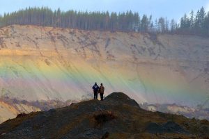
‘Flood of emotions’ as Oso Landslide Memorial opens on 10th anniversary
Friends, family and first responders held a moment of silence at 10:37 a.m. at the new 2-acre memorial…
March 22, 2024
Local News
How to watch the Oso landslide ceremony for the 10th anniversary
A ceremony to honor the 43 lost on March 22, 2014, began at 10 a.m. Friday.
March 22, 2024
Local News
How Oso slide changed local emergency response ‘on virtually every level’
“In a decade, we have just really, really advanced,” through hard-earned lessons applied to the pandemic, floods and…
March 22, 2024
Local News
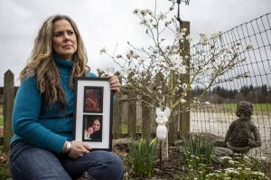
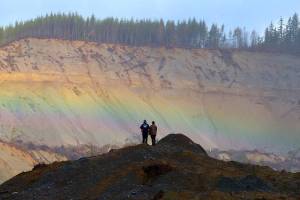
In shadow of scarred Oso hillside, mudslide’s wounds still feel fresh
Locals reflected on living with grief and finding meaning in the wake of a catastrophe “nothing like you…
March 22, 2024
Local News
A recap of the Oso mudslide through The Daily Herald archives
Here’s an overview of past Herald coverage of the 2014 Oso mudslide.
March 21, 2024
Local News
‘It just all came down’: An oral history of the Oso mudslide
Ten years later, The Daily Herald spoke with dozens of people — first responders, family, survivors — touched…
March 21, 2024
Local News
Remembering the 43 lives lost in the Oso mudslide
The slide wiped out a neighborhood along Highway 530 in 2014. “Even though you feel like you’re alone…
March 21, 2024
Local News
In recent deadly landslide in Alaska, echoes of Oso
The landslide lacked the scale of what happened in Oso a decade ago. But it also rocked a…
March 21, 2024
Local News
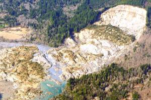
A brief timeline of the Oso mudslide
Ten years ago, the deadliest slide in U.S. history struck between Arlington and Darrington. Here’s a look back.
March 20, 2024
Local News
What geologists learned from Oso, and what they wish they knew in 2014
Too often with natural hazards, it takes a tragedy, geologists said. Now the state allocates millions to mapping…
March 19, 2024
Local News
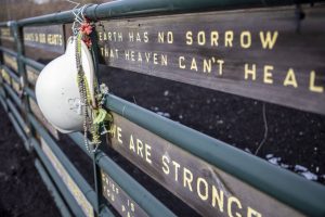
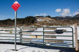
New memorial means ‘everything’ to survivors, 10 years after Oso slide
At the 2-acre site, bronze and steel sculptures rise against the backdrop of the slide, making use of…
March 19, 2024
Local News
In Oso, lost neighbors always ‘in our hearts — never forgotten’
Eight years ago, 43 people were lost in the Oso slide. As they do every year, friends and…
March 23, 2022
Local News
Highway 530 slide memorial to be a ‘beautiful place’
The hope is to complete work at the site near Oso in time for a 10-year remembrance ceremony…
March 16, 2022
Local News
Funding secured: Mudslide memorial will be a place to remember
Since 2014, families have mourned at a roadside shrine near Oso, but “we knew we needed something bigger.”
November 30, 2021
Local News
7 years ago: ‘We waved hello, not realizing it was a goodbye’
Forty-three people perished in the 2014 Oso mudslide. On Monday, the community gathered again.
March 22, 2021
Local News
President signs bill to boost mapping of landslide hazards
The bill appropriates $40 million annually for 3D mapping and disaster preparation.
January 9, 2021
Local News
New program may help pinpoint landslides before they happen
A bill pushing more funding toward 3D mapping and disaster preparation is on the president’s desk.
December 25, 2020
Local News
Six years later, Oso remembers landslide victims, survivors
People gathered to reflect on the loss of 43 people. Work remains for raising money for a memorial.
March 23, 2020
Local News
Gala to raise money for permanent Oso landslide memorial
The PNW Paradise Ball and Auction will benefit a $6 million commemoration and education project.
June 13, 2019
Local News
Oso Mudslide: Loss and Courage
From 2014, our video about the disaster and its aftermath.
March 22, 2019
1
2
3
Next