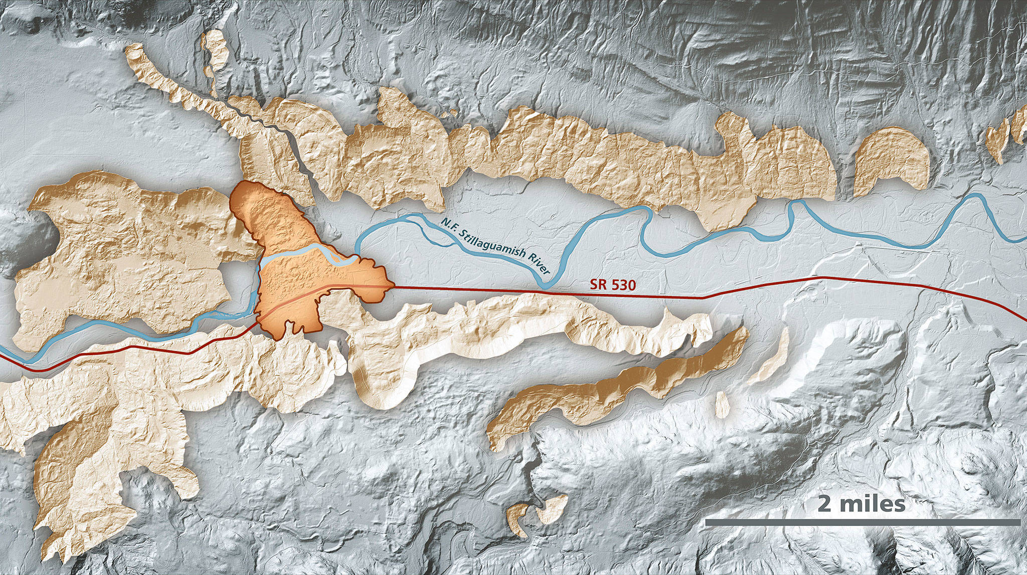
Lidar imagery enables geologists to accurately identify landslides, such as the area around the Highway 530 Oso landslide. In this area, lidar data show prehistoric landslides in beige along the North Fork Stillaguamish River. The darker-shaded, outlined area is the extent of the March 2014 Oso landslide. (Daniel Coe/Washington State Department of Natural Resources)

Lidar imagery enables geologists to accurately identify landslides, such as the area around the Highway 530 Oso landslide. In this area, lidar data show prehistoric landslides in beige along the North Fork Stillaguamish River. The darker-shaded, outlined area is the extent of the March 2014 Oso landslide. (Daniel Coe/Washington State Department of Natural Resources)

New program may help pinpoint landslides before they happen

A bill pushing more funding toward 3D mapping and disaster preparation is on the president’s desk.

OSO — A new national program will increase 3D mapping of landslide risks to anticipate disasters like the deadly Oso mudslide that struck nearly seven years ago.

Legislation passed by Congress Dec. 16 dramatically increases the use of a laser-surveying technology known as Lidar to map, identify and track potential landslide areas. Lidar stands for Light Detection and Ranging.

Congresswoman Suzan DelBene, whose district includes Oso, and Washington Sen. Maria Cantwell introduced the bill.

“Employing our best science and mapping technologies will help communities across our state save lives, safeguard property, and improve our emergency planning and response,” Cantwell said in a statement.

Passage of the bill marks a shift in the U.S. government’s consideration of landslides as a secondary risk to earthquakes, floods and volcano eruptions.

Currently, “Landslides are sort of dealt with as an after-effect of other natural disasters,” said Nick Martin, a spokesperson for DelBene.

Now, the U.S. Geological Survey will treat landslides as a primary natural disaster.

The new bill gives the survey funding to form a program specifically for landslides, with its own dedicated staff.

They’ll get $40 million annually for a 3D mapping program, but that money is spread throughout the whole nation.

As it is, state governments, local communities and tribes are responsible for initiating any mapping. The new federal program will centralize that data collection.

“With programs like this, communities across the country will be able to understand where you could see shifts in the ground and be able to better predict where ground has a greater likelihood of a slide,” Martin said.

The federal program will complement efforts by Washington’s Department of Natural Resources and counterpart agencies in other states.

DNR has made progress mapping and analyzing data about the glacially formed landscape in the upper half of the state, including Snohomish County. The work relies heavily on aerial maps created using lidar.

Each year, landslides kill 25 to 50 people and cause between $1.6 billion and $3.2 billion in damage in the United States.

The 2014 Oso mudslide near Darrington, a catastrophe that destroyed 49 homes and took 43 lives, along with a recent landslide in Haines, Alaska, played a large role in pushing the legislation’s passage.

DelBene first introduced the bill in 2016, and has reintroduced it every session since.

“The legislation that Representative DelBene has brought forward may not prevent another Oso slide,” Darrington Mayor Dan Rankin said. “But it gives communities like Darrington data that we can use to make important decisions about land use in hazard areas, training for our emergency services, and redundancy in infrastructure so precious time is not lost in a time of need.”

Julia-Grace Sanders: 425-339-3439; jgsanders@heraldnet.com; Twitter: @sanders_julia.

Talk to us

> Give us your news tips.

> Send us a letter to the editor.

> More Herald contact information.
More in Local News

Everett Historic Theater owner Curtis Shriner inside the theater on Tuesday, May 13, 2025 in Everett, Washington. (Olivia Vanni / The Herald)
Historic Everett Theatre sale on horizon, future uncertain

With expected new ownership, events for July and August will be canceled. The schedule for the fall and beyond is unclear.

Contributed photo from Snohomish County Public Works
Snohomish County Public Works contractor crews have begun their summer 2016 paving work on 13 miles of roadway, primarily in the Monroe and Stanwood areas. This photo is an example of paving work from a previous summer. A new layer of asphalt is put down over the old.
Snohomish County plans to resurface about 76 miles of roads this summer

EVERETT – As part of its annual road maintenance and preservation program,… Continue reading

City of Everett Engineer Tom Hood, left, and City of Everett Engineer and Project Manager Dan Enrico, right, talks about the current Edgewater Bridge demolition on Friday, May 9, 2025 in Everett, Washington. (Olivia Vanni / The Herald)
How do you get rid of a bridge? Everett engineers can explain.

Workers began dismantling the old Edgewater Bridge on May 2. The process could take one to two months, city engineers said.

Smoke from the Bolt Creek fire silhouettes a mountain ridge and trees just outside of Index on Sept. 12, 2022. (Olivia Vanni / The Herald)
County will host two wildfire-preparedness meetings in May

Meetings will allow community members to learn wildfire mitigation strategies and connect with a variety of local and state agencies.

Helion's 6th fusion prototype, Trenta, on display on Tuesday, July 9, 2024 in Everett, Washington. (Olivia Vanni / The Herald)
Helion celebrates smoother path to fusion energy site approval

Helion CEO applauds legislation signed by Gov. Bob Ferguson expected to streamline site selection process.

Vehicles travel along Mukilteo Speedway on Sunday, April 21, 2024, in Mukilteo, Washington. (Ryan Berry / The Herald)
Mukilteo cameras go live to curb speeding on Speedway

Starting Friday, an automated traffic camera system will cover four blocks of Mukilteo Speedway. A 30-day warning period is in place.

Carli Brockman lets her daughter Carli, 2, help push her ballot into the ballot drop box on the Snohomish County Campus on Tuesday, Nov. 5, 2024 in Everett, Washington. (Olivia Vanni / The Herald)
Here’s who filed for the primary election in Snohomish County

Positions with three or more candidates will go to voters Aug. 5 to determine final contenders for the Nov. 4 general election.

Sound Transit approves contract to build Bothell bus facility

The 365,000-square-foot facility will be the heart of the agency’s new Stride bus rapid transit system, set to open in 2028.

One dead in Everett crash involving motorcycle and two vehicles

Police shut down the 10300 block of Evergreen Way in both directions during the multi-vehicle collision investigation.

Katie Wallace, left, checks people into the first flight from Paine Field to Honolulu on Friday, Nov. 17, 2023 in Everett, Washington. (Olivia Vanni / The Herald)
Executive order makes way for Paine Field expansion planning

Expansion would be a long-range project estimated to cost around $300 million.

A person pauses to look at an art piece during the Schack Art Center’s 50th anniversary celebration on Thursday, Oct. 10, 2024 in Everett, Washington. (Olivia Vanni / The Herald)
Everett to seek Creative District designation

The city hopes to grow jobs in the creative sector and access new grant funds through the state label.

Former Herald writer Melissa Slager’s new book was 14-year project

The 520-page historical novel “Contests of Strength” covers the 1700 earthquake and tsunami on Makah lands.

Support local journalism

If you value local news, make a gift now to support the trusted journalism you get in The Daily Herald. Donations processed in this system are not tax deductible.