Editorial: Mapping landslide risks honors those lost in Oso
Published 1:30 am Thursday, March 21, 2024


By The Herald Editorial Board
In the 10 years since the Oso landslide struck on a clear Saturday morning along the North Fork of the Stillaguamish River, work on two memorials has continued, honoring the memories of 43 residents of the Steelhead Haven neighborhood who died there, those who survived, the first responders and others who spent months at the site and the valley communities that worked to rebuild after the disaster.
Friday morning at 10:38, a two-acre memorial park off Highway 530 — the still-scarred hillside rising above it — will be officially dedicated. Among smaller memorials, a steel and bronze pillar rises above a stone and concrete plaza. Five years ago a bronze sculpture of a line of the neighbors’ mailboxes on Steelhead Drive was dedicated.
A second memorial is more mundane, but just as substantial. This memorial is made of laser measurements, tables of data, geologic history, observations, maps, political will and taxpayer revenue, intended to prevent a similar loss of life in one of the nation’s more geologically active regions and throughout the United States.
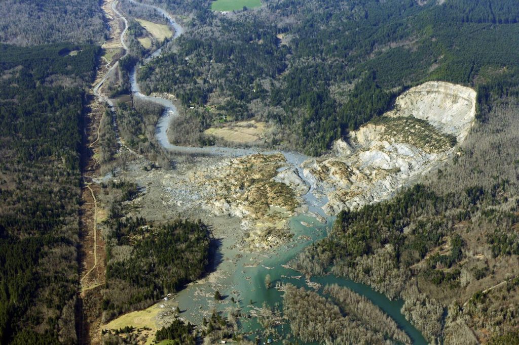
Ten years ago, some 18 million tons of rain-sodden mud, clay, sand and vegetation broke free from the hillside above the Stilly River and Steelhead Haven, burying homes, families, the river and Highway 530 in debris that piled more than 30 feet high in areas. The highway, connecting Arlington and Darrington opened three months later. The body of the last victim wasn’t recovered until that July.
Landslides are not uncommon, not in Washington state among its mountain ranges and shoreline bluffs, nor in Snohomish County, nor in the Stilly Valley. In fact, a landslide struck nearby slopes eight years before. The Hazel Landslide in 2006 traveled more than 300 feet down the hillside, before stopping short of Steelhead Haven.
The Oso Landslide, however, galvanized residents, community leaders and public officials to take action. Landslides can’t be stopped — anymore than floods or volcanoes — but homes and communities can be kept out of their way.
Oso was a wake-up call for the state as to the risks and dangers of landslides and their potential for destruction, said Hilary Franz, the state commissioner of public lands and head of the state Department of Natural Resources, in an interview last week. What followed the disaster was an effort to sharpen the understanding of how landslides happen, what factors contribute to their risks and what could be done to prepare and plan for them.
And that work, amid a changing climate, is all the more imperative.
“It’s important for us to understand how landslides happen with a changing climate, wetter winters, windstorms, drought, wildfires and how those contribute to the risks of landslides,” she said.
Since the slide, state and federal agencies have undertaken sweeping efforts to map landslide hazards in Washington state, supported by about $13 million in funding from the state’s Landslide Hazards Program since 2015 and another $5 million in federal funding that was part of the federal National Landslide Hazards Reduction Preparedness Act though the work of the U.S. Geological Survey.
To date, topographic measurements have been made of nearly the entire state of Washington using lidar — light detection and ranging — which uses laser light to peer past vegetation to understand the lay of the land and find areas where landslides have occurred, even those before recorded history.
But that work to review that data has only started, said Casey Hanell, state geologist and director of the state geological survey. And it’s only since the Oso slide that the state’s one geologist has been joined by four others.
The painstaking work to review that data, make onsite observations and map the hazards is only 14 percent complete, Hanell said, with areas prioritized based on geology, risk and population. Topography and landslide risks have been mapped for nearly all of Snohomish, King and Pierce counties as well as the western half of Whatcom County and much of the Columbia River Gorge. The survey now is working on Thurston and Skamania counties. And work will continue with new lidar recordings to update maps over time, he said.
“The lidar readings are critical to showing all those hidden landslides that have happened in the past and where they might happen in the future,” Hanell said.
The lidar measurements, rather than ground-breaking, have been ground-revealing.
University of Washington geomorphologist David Montgomery, who has studied the Oso landslide, described their importance to The Herald’s Ta’Leah Van Sistine this week:
“It was like getting a brand new pair of glasses for looking at the land,” Montgomery said.
Even with only 14 percent of the state mapped, Hanell said, nearly 35,000 past landslides have been catalogued. Included in that mapping are at least 25 landslides along the Stillaguamish Valley near the Oso slide that have happened in the last 5,000 years.
With access to those maps, planners and officials for cities and counties can make sure future developments and homes aren’t built in areas at risk for landslides. In 2015, the Snohomish County Council roughly tripled the no-build area around steep slopes seen as prone to sliding, the Washington State Standard reported this week. Snohomish County Planning and Development Services estimated that it sees about 10 case a year where it has required a building permit applicant to hire a geotechnical engineer to determine if and where a house can safely be built on a property.
The DNR also offers a 12-page homeowner’s guide to landslides for Washington and Oregon with explanations, warning signs and tips for siting homes.
The work, Franz said, is a long way from complete and will depend on continued funding from the state. As well, more federal funding already has been proposed.
U.S. Rep. Suzan DelBene, D-Wash., whose district at the time of the slide included the Stillaguamish Valley, has sponsored a bill to renew the federal landslide hazards program, which would otherwise expire this September. The bipartisan House bill, joined by all 10 members of the state’s delegation seeks continued funding of $25 million each year, through 2028 for the nationwide program. A Senate version of the bill, co-sponsored by U.S. Sen. Maria Cantwell, would authorize $40 million annually through 2034.
Those figures should be measured against the losses that landslides cause to U.S. communities each year, including 25 to 50 deaths and $1.6 billion to $3.2 billion in property and infrastructure losses, statistics cited by DelBene in introducing the legislation in late January.
Ten years after Oso, landslides continue to kill. A debris flow, hastened by the loss of vegetation from a wildfire near Montecito, Calif., killed 23 people and destroyed more than 100 homes in 2018. And six people lost their lives last year near Wrangell, Alaska, when heavy rains triggered a landslide.
Landslides will continue; they can’t be stopped. But planning and precautions can keep people, housing and infrastructure away from those areas most at risk.
“We owe it to the people who lost their lives and lost loved ones, and to first responders to make sure we don’t have another Oso disaster,” the DNR’s Franz said.