By Brian McNoldy
The Washington Post
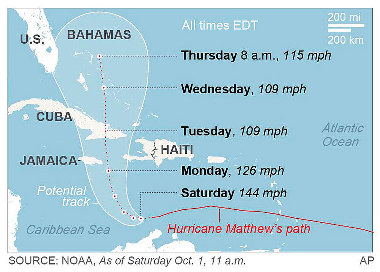
Hurricane Matthew remains an extremely powerful Category 4 hurricane, and it is now less than a day away from producing a prolonged period of life-threatening conditions in parts of Haiti, Cuba and Jamaica. Ultimately, those conditions will extend into the Bahamas.
Some impacts along the U.S. East Coast now appear to be more likely as we look toward the weekend, although there is a large amount of uncertainty. While there is more suggestion of a coastal scrape than a landfall at this time, a U.S. landfall certainly isn’t out of the question.
Matthew’s maximum winds are back up to 140 mph after falling slightly overnight. It is expected to maintain that intensity until land interactions start to affect it.
Hurricane warnings are in effect for Jamaica, Haiti, eastern Cuba and the eastern Bahamas. It is tracking due north at 6 mph, and that slow forward motion will unfortunately keep the high wind and heavy rain over the same areas for an extended amount of time. Some places may be battered for perhaps two days.
Although tropical storm force winds extend about 135 miles from the center, hurricane-force winds only extend out to roughly 30 miles.
If the center stays far enough from Jamaica, that nation could avoid the worst of the winds, although heavy rain is still a big concern.
The storm surge along Haiti’s and Cuba’s southern coasts is predicted to be 7 to 11 feet. This is a very real danger that must not be overlooked or underestimated. The rainfall forecast for Haiti is especially ominous, but eastern Jamaica and eastern Cuba are not far behind. Parts of Haiti could receive up to 40 inches of rain. This is likely to produce terrible flash floods and mudslides.
At approximately 2 a.m. EDT Monday, Matthew’s eye passed almost directly over a buoy (National Data Buoy Center Station 42058) in the central Caribbean and recorded a 943 millibar surface pressure in the eye, with 74 mph sustained winds and 92 mph wind gusts in both sides of the eyewall.
It is extraordinary to have a major hurricane pass right over a buoy – and as a bonus, the buoy survived! Extreme wind speeds reported by buoys can be tricky to interpret though, because the buoy bobs up and down with the swells and waves, so when the buoy is on the crest of a wave it is fully exposed to the winds, but when it is in a trough between waves, it is blocked somewhat. In this case, the “significant wave height” was 34 feet, or about 20 feet higher than the anemometer.
Haiti has been hit or grazed by numerous very strong hurricanes over the centuries, but even weaker storms that pass nearby have produced devastating floods and mudslides.
Direct landfalls on Haiti, by major hurricanes, include David (1979), Inez (1966), Cleo (1964), Flora (1963) and Hazel (1954). Several other extremely intense storms passed very close, such as Allen (1980). Other recent natural disasters include the 2008 hurricane season when hurricanes Fay, Gustav, Hanna and Ike all ravaged the country, and then the infamous 2010 earthquake. It currently seems unfortunately likely that Matthew will become an addition to that grim list.
Looking beyond the next three days of continuous island encounters, Matthew’s longer-range track still keeps the U.S. East Coast in play.
It now appears likely that it will remain far enough east of Florida that only fringe effects and tropical storm conditions should be experienced along the peninsula on Thursday and Friday. This means prolonged full-blown hurricane conditions are not anticipated there. But we need to watch this, as a slight westward nudge in the track could bring hurricane conditions to parts of Florida’s east coast.
Looking further ahead to Friday and the weekend, the southeast United States, the Mid-Atlantic states and the northeast are certainly still at risk. Matthew could still be a strong hurricane at that time as well. A number of skillful track models agree on a too-close-to-call scenario this far out.
The latest five-day tropical storm wind speed probability map includes greater than 20 percent probabilities for eastern Florida and the Carolinas. Keep in mind that this product extends out only to early Saturday morning. Even if the storm remains offshore, it could be close enough to produce storm surges and coastal erosion.
The timing and strength of the next trough of low pressure moving through North America will determine if Matthew will get swept out to sea or if it will make landfall first and then get pushed out.
Matthew has now been a major hurricane for 72 hours, and it had winds of at least 145 mph for a much of that time. CWG’s tropical analyst Phil Klotzbach pointed out last night via Twitter that this is the longest we’ve had such a strong storm in the Atlantic Ocean in 11 years.
Prior to Matthew’s formation, the season’s Accumulated Cyclone Energy (ACE) was at approximately 70 percent of an average season for the date. As of today, the season is at about 89 percent of average for this date. ACE is a metric that takes into account both the intensity and the longevity of tropical cyclones, so a long-lived strong hurricane will make a big contribution.
With Matthew expected to continue churning for at least a week to 10 days, these ACE numbers will continue to rise. The storm’s overall toll will increase as well, as it begins to impact population in a way it has not done to this point.
Talk to us
> Give us your news tips.
> Send us a letter to the editor.
> More Herald contact information.


