A slow-moving landslide near Oso prompted a closure of Highway 530. (State Department of Natural Resources, via the Snohomish County Sheriff’s Office.)

A slow-moving landslide near Oso prompted a closure of Highway 530. (State Department of Natural Resources, via the Snohomish County Sheriff’s Office.)

Mudslide closes Highway 530 near Oso through Monday morning

UPDATE 2:30 p.m.: Highway 530 will stay closed east of Oso at least until Monday morning due to safety concerns about a slow-moving mudslide on a hillside above the roadway, state officials said.

— — — — — — — —

UPDATE 10:30 a.m.: Highway 530 remained closed at Oso Loop Road, about one and a half miles east of Oso, as a precaution.

The slide occurred on a Department of Natural Resources road that runs through private property, said Kris Olsen, a spokeswoman with the state Department of Transportation. The slide is above the south side of the highway, about 1.5 miles west from where the 2014 disaster.

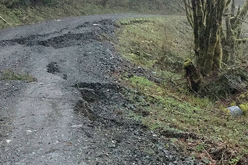
State geologists observed cracks in the road when they visited early Friday afternoon, Olsen said. Several hours later, they returned and saw that the land had shifted about 2 feet.

“It is actively moving up there,” Olsen said.

People voluntarily left 10 homes. Occupants of another home decided to stay put.

More than a dozen experts from the state and Snohomish County were at the slide site on Saturday morning to evaluate safety risks.

No updates were expected before noon.

Officials at the Oso fire station included Snohomish County Executive Dave Somers and Councilman Nate Nehring.

— — — — — — — — —

UPDATE: Highway 530 remained closed near Oso on Saturday morning as engineers assess risks from a mudslide discovered a day earlier.

Washington state Department of Transportation had no estimate for when the roadway would reopen, spokeswoman Nicole Daniels said shortly after 8 a.m. State geotechnical engineers were on the scene.

————————————

OSO — Highway 530 was closed near Oso on Friday night as a precaution because of a mudslide. No property damage or injuries were reported. Voluntary evacuations of about 10 properties were ongoing as of 10 p.m., mostly along Whitman Road.

At least one home was threatened, officials said.

The unstable hillside is on private land above the highway. The ground was moving, but slowly, according to the Snohomish County Sheriff’s Office.

“This is all a precaution,” sheriff’s spokeswoman Shari Ireton said.

The location is southwest of the 2014 disaster site, near Skaglund Hill, according to the state Department of Transportation. It also is south of the highway. A state geologist was there earlier Friday after reports of cracks along a back-country road.

The road closure started around 8 p.m. at Milepost 36, which is between the Oso fire station and the 2014 disaster site. The closure was expected to last until daylight Saturday, when crews can get a better view.

Heavy rain has saturated the ground in parts of Western Washington, and there have been repeated warnings of potential slides in the region. Those generally are different than the deep-seated geological shift in 2014 that took 43 lives and blocked the North Fork Stillaguamish River.

The slide that prompted the highway closure Friday appeared to be in the same area as large cracks that have developed along a U.S. Forest Service road near Oso, prompting a closer look by county officials for potential mudslide risks.

A county employee on Friday documented what appeared to be an ongoing mudslide on the south side of Highway 530, near Milepost 35. That area is west of Skaglund Hill, where the state has performed millions of dollars in work to reinforce steep slopes.

A county engineer said the tension cracks deserve further examination by specialists, though Lidar surface-mapping data did not show an obvious history of landslides in the area. Local, state and federal officials were alerted to the situation. The rain and the area’s soil characteristics add to the concern.

Talk to us

> Give us your news tips.

> Send us a letter to the editor.

> More Herald contact information.

More in Local News

Logo for news use featuring Snohomish County, Washington. 220118
Health officials: Three confirmed measles cases in SnoCo over holidays

The visitors, all in the same family from South Carolina, went to multiple locations in Everett, Marysville and Mukilteo from Dec. 27-30.

Dog abandoned in Everett dumpster has new home and new name

Binny, now named Maisey, has a social media account where people can follow along with her adventures.

People try to navigate their cars along a flooded road near US 2 on Wednesday, Dec. 10, 2025, in Sultan, Washington. (Olivia Vanni / The Herald)
Temporary flood assistance center to open in Sultan

Residents affected by December’s historic flooding can access multiple agencies and resources.

Logo for news use featuring the Tulalip Indian Reservation in Snohomish County, Washington. 220118
Teens accused of brutal attack on Tulalip man Monday

The man’s family says they are in disbelief after two teenagers allegedly assaulted the 63-year-old while he was starting work.

A sign notifying people of the new buffer zone around 41st Street in Everett on Wednesday, Jan. 7. (Will Geschke / The Herald)
Everett adds fifth ‘no sit, no lie’ buffer zone at 41st Street

The city implemented the zone in mid-December, soon after the city council extended a law allowing it to create the zones.

A view of the Eastview development looking south along 79th Avenue where mud and water runoff flowed due to rain on Oct. 16, 2025 in Snohomish, Washington. (Olivia Vanni / The Herald)
Eastview Village critics seek appeal to overturn county’s decision

Petitioners, including two former county employees, are concerned the 144-acre project will cause unexamined consequences for unincorporated Snohomish County.

Snohomish County commuters: Get ready for more I-5 construction

Lanes will be reduced along northbound I-5 in Seattle throughout most of 2026 as WSDOT continues work on needed repairs to an aging bridge.

Logo for news use featuring the municipality of Snohomish in Snohomish County, Washington. 220118
Snohomish man held on bail for email threat against Gov. Ferguson, AG Brown

A district court pro tem judge, Kim McClay, set bail at $200,000 Monday after finding “substantial danger” that the suspect would act violently if released.

Kathy Johnson walks through vegetation growing along a CERCLA road in the Mt. Baker-Snoqualmie National Forest on Thursday, July 10, 2025 in Granite Falls, Washington. (Olivia Vanni / The Herald)
Activism groups to host forest defense meeting in Bothell

The League of Women Voters of Snohomish County and the Pacific Northwest Forest Climate Alliance will discuss efforts to protect public lands in Washington.

Debris shows the highest level the Snohomish River has reached on a flood level marker located along the base of the Todo Mexico building on First Street on Friday, Dec. 12, 2025 in Snohomish, Washington. (Olivia Vanni / The Herald)
SnoCo offers programs to assist in flood mitigation and recovery

Property owners in Snohomish County living in places affected by… Continue reading

Emily Trepanier on Friday, Jan. 16, 2026 in Everett, Washington. (Olivia Vanni / The Herald)
‘I’m going to die’: Two childhood friends recount hours-long ordeal on Mt. Baker

A fallen tree trapped the pair partway down the mountain for several hours in the snow.

With the warm atmosphere, freshly made food and a big sign, customers should find their way to Kindred Kitchen, part of HopeWorks Station on Broadway in Everett. (Dan Bates / The Herald)
Housing Hope to close cafe, furniture store

Kindred Cafe will close on Jan. 30, and Renew Home and Decor will close on March 31, according to the nonprofit.

Support local journalism

If you value local news, make a gift now to support the trusted journalism you get in The Daily Herald. Donations processed in this system are not tax deductible.