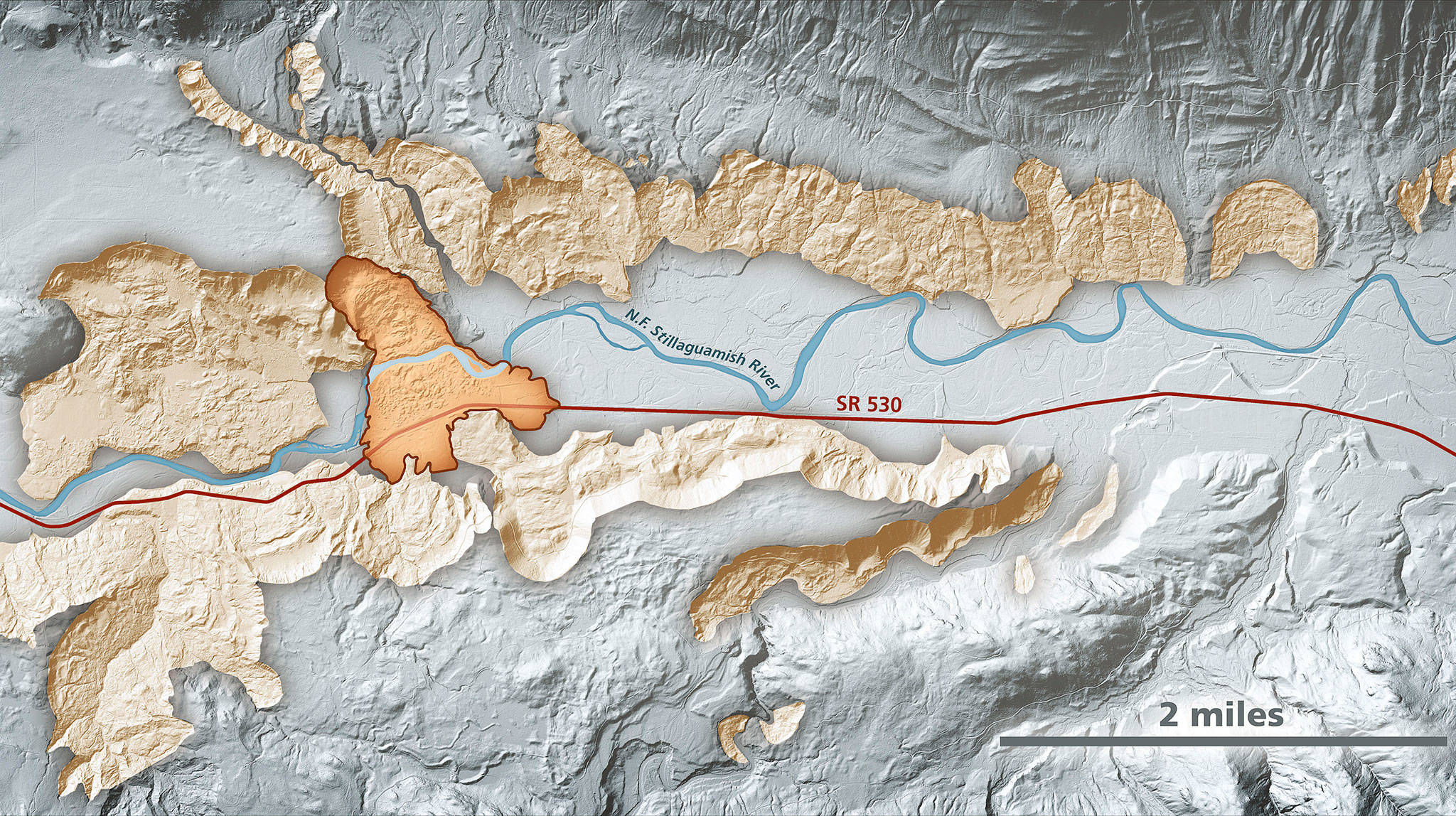
Lidar imagery enables geologists to accurately identify landslides, such as the area around the Highway 530 Oso landslide. In this area, lidar data show prehistoric landslides in beige along the North Fork Stillaguamish River. The darker-shaded, outlined area is the extent of the March 2014 Oso landslide. (Daniel Coe/Washington State Department of Natural Resources)

Lidar imagery enables geologists to accurately identify landslides, such as the area around the Highway 530 Oso landslide. In this area, lidar data show prehistoric landslides in beige along the North Fork Stillaguamish River. The darker-shaded, outlined area is the extent of the March 2014 Oso landslide. (Daniel Coe/Washington State Department of Natural Resources)

State plugs away at mapping landslide-prone areas

The DNR wants to study the area around the Oso slide and similar terrain across the state.

OSO — Nearly five years after a massive mudslide swept across the Stillaguamish Valley, claiming dozens of lives, state geologists still are trying to get a better grasp of the area’s natural hazards.

Mapping and analysis have been ongoing and will be for years to come. It’s an effort not only in Snohomish County but for the entire upper half of Washington, where glaciers carved out similar landscapes.

“There are a lot of questions that need to be answered,” state geologist Dave Norman said. “Why did it move so far? Why did it run out so quickly?”

The Department of Natural Resources has requested $1.4 million to study the Highway 530 corridor over the next two years and $1.1 million for the two years after that. The money would pay for two geologists to research, map and monitor the 50-square-mile corridor around the site of the Oso, according to the DNR’s budget request. The research would help scientists figure out how to go about studying landslide risks across 18 counties in northern Washington with similar glacial geology.

Gov. Jay Inslee did not include the money in his recommended 2019-2021 budget. The DNR has put in the same request to state lawmakers, who are working to draft a final spending plan this spring.

The Oso mudslide struck on the morning of March 22, 2014. A hillside collapsed above the North Fork Stillaguamish River, sending earth, water and trees southward. Centered on the Steelhead Haven neighborhood, the slide killed 43 people, took out a stretch of highway and covered a square mile in debris.

The scale of the disaster caught experts and laypeople off guard, though there’s evidence that slopes to either side of the valley have been sliding for thousands of years.

“Just about every major river valley that comes out of the Cascades and flows into the Sound, you have very similar situations as the north fork of the Stillaguamish,” Norman said.

In the aftermath of the deadly slide, Inslee’s office and then-Snohomish County Executive John Lovick convened an expert commission to chart a better course for understanding and reacting to landslide dangers. Among the panel’s recommendations in December 2014 was to “significantly expand data collection and landslide mapping efforts” for landslide hazards.

The highest priority areas included the Everett-Seattle rail line, highways through the Cascade Range and densely populated regions.

The state has made progress, though the program has never received quite as much money as anticipated.

A major tool has been lidar imagery. The three-dimensional maps of the Earth’s surface are created using airplane-mounted lasers. They can reveal features obscured by trees and buildings. In addition to landslides, the images are useful for identifying areas at risk for flooding, tsunamis and other natural disasters, according to the DNR.

“We’ve gathered it all up into one place and one portal,” Norman said. “It wasn’t necessarily publicly available. The portal has been a huge success.”

The DNR’s potential work in the Stillaguamish Valley over the coming years would require boots on the ground, in addition to aerial imagery. Scientists would like to complete more bore-hole testing to better understand the area’s geology, said Stephen Slaughter, the DNR’s landslides hazards program manager.

The DNR continues to release better landslide information for the whole state. In January, the agency published an inventory of 2,838 landslides in King County using new lidar images. Many of those slides were found along Puget Sound bluffs, rivers and mountains, according to a press release. That number doesn’t include smaller landslides, like the kind that block roads after heavy rains.

The state has completed similar landslide inventories for Pierce County and the Columbia Gorge, Slaughter said. The next inventories state geologists expect to complete are for Whatcom and Skagit counties, with Snohomish County likely to follow in 2020.

“We’d like to complete the entire state,” Slaughter said.

Land isn’t static. Norman, the state geologist, said he’d like to have fresh yearly images along the North Fork Stillaguamish River.

“If you do this frequently enough, you can do this as a change analysis,” he said. “That would indicate movement.”

Noah Haglund: 425-339-3465; nhaglund@heraldnet.com. Twitter: @NWhaglund.

Talk to us

> Give us your news tips.

> Send us a letter to the editor.

> More Herald contact information.
More in Local News

Snohomish residents Barbara Bailey, right, and Beth Jarvis sit on a gate atop a levee on Bailey’s property on Monday, May 13, 2024, at Bailey Farm in Snohomish, Washington. Bailey is concerned the expansion of nearby Harvey Field Airport will lead to levee failures during future flood events due to a reduction of space for floodwater to safely go. (Ryan Berry / The Herald)
Harvey Field seeks to reroute runway in floodplain, faces new pushback

Snohomish farmers and neighbors worry the project will be disruptive and worsen flooding. Ownership advised people to “read the science.”

IAM District 751 machinists join the picket line to support Boeing firefighters during their lockout from the company on Thursday, May 16, 2024, in Everett, Washington. (Ryan Berry / The Herald)
Amid lockout, Boeing, union firefighters return to bargaining table

The firefighters and the planemaker held limited negotiations this week: They plan to meet again Monday, but a lockout continues.

Lynnwood
Lynnwood woman sentenced for stabbing Bellingham woman while she slept

Johanna Paola Nonog, 23, was sentenced last week to nine years in prison for the July 2022 stabbing of a woman she’d recently met.

Granite Falls
Man presumed dead after fall into river near Granite Falls

Around 5 p.m. Sunday, the man fell off smooth rocks into the Stillaguamish River. Authorities searched for his body Monday.

Pilot found dead near Snoqualmie Pass after Arlington flight

Jerry Riedinger’s wife reported he never made it to his destination Sunday evening. Wreckage of his plane was found Monday afternoon.

Firefighters respond to a fire on Saturday morning in Lake Stevens. (Photo provided by Snohomish Regional Fire & Rescue)
1 woman dead in house fire east of Lake Stevens

Firefighters responded to find a house “fully engulfed in flames” in the 600 block of Carlson Road early Saturday.

YMCA swim instructor Olivia Beatty smiles as Claire Lawson, 4, successfully swims on her own to the wall during Swim-a-palooza, a free swim lesson session, at Mill Creek Family YMCA on Saturday, May 18, 2024 in Mill Creek, Washington. (Olivia Vanni / The Herald)
Splish splash! YMCA hosts free swim lessons around Snohomish County

The Y is building a “whole community” of water safety. On Saturday, kids got to dip their toes in the water as the first step on that journey.

Bothell
2 injured in Bothell Everett Highway crash

The highway was briefly reduced to one northbound lane while police investigated the three-car crash Saturday afternoon.

Heavy traffic northbound on 1-5 in Everett, Washington on August 31, 2022.  (Kevin Clark / The Herald)
On I-5 in Everett, traffic nightmare is reminder we’re ‘very vulnerable’

After a police shooting shut down the freeway, commutes turned into all-night affairs. It was just a hint of what could be in a widespread disaster.

The Eternal Flame monument burns in the center of the Snohomish County Campus on Thursday, Nov. 3, 2022 in Everett, Washington. (Olivia Vanni / The Herald)
Elected officials to get 10% pay bump, or more, in Snohomish County

Sheriff Susanna Johnson will see the highest raise, because she was paid less than 10 of her own staff members.

Anthony Brock performs at Artisans PNW during the first day of the Fisherman’s Village Music Fest on Thursday, May 16, 2024 in Everett, Washington. (Olivia Vanni / The Herald)
At downtown Everett musical festival: ‘Be weird and dance with us’

In its first night, Fisherman’s Village brought together people who “might not normally be in the same room together” — with big acts still to come.

Two troopers place a photo of slain Washington State Patrol trooper Chris Gadd outside District 7 Headquarters about twelve hours after Gadd was struck and killed on southbound I-5 about a mile from the headquarters on Saturday, March 2, 2024, in Marysville, Washington. (Ryan Berry / The Herald)
Judge reduces bail for driver accused of killing Marysville trooper

After hearing from Raul Benitez Santana’s family, a judge decreased bail to $100,000. A deputy prosecutor said he was “very disappointed.”

Support local journalism

If you value local news, make a gift now to support the trusted journalism you get in The Daily Herald. Donations processed in this system are not tax deductible.